Wind Map
by Andrew Hall
The face of the Earth was shaped by three primary means: volcanic eruption, lightning, and wind. It occurred in primordial storms which significantly ionized the atmosphere, charged the ground like a battery, and discharged energy between them in the same way we see today: earthquakes, volcanoes and storms. Only these storms were beyond biblical. They occurred before Man arrived. These were the storms of creation, which shaped the face of the planet.
Because wind played the predominant role in laying and piling the sediments that most of us now live on, its effects are most visible to us. Once you start recognizing the characteristics of wind-formed topography, it becomes impossible to ignore.
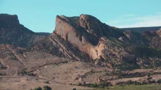
To identify wind direction, look at mountains. Mountains (not volcanoes) are all essentially wind blown dunes. One side will be windward and one side will be leeward to the wind that formed them, and like a dune, reflects this in their shape. The leeward side is generally steep and slab sided, and the windward side dips at shallower slope.

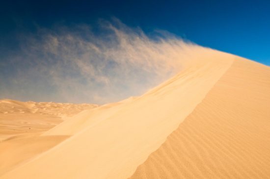
The windward side actually portrays the shape of the wind itself, as pressure waves undulate across movable sands and mold them. The interface between wind and sand is created by the motions of the wind.
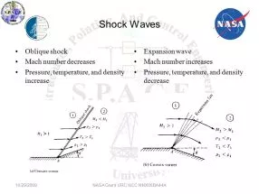
If the wind reaches Mach speed, standing shock waves reflect from any protrusion in the wind’s path and cause a sharp crease in the wind direction. Distinct patterns form at this crease where the wind direction changes abruptly. The reflected standing shock wave forms a fan-shaped interference pattern of compression and rarefaction. This pattern can be found on most mountain forms, including Cordillera mountain arcs, continental divides, lone inselbergs, and ‘island in the sky’ basin and range mountain structures.
Dust laden supersonic winds deposit their heavy cargo where the crease in the wind forms. A tetrahedron-shaped zone of rarefaction (low pressure) develops at the root of the standing wave, called a “separation bubble.” Wind-born dust collects in this bubble as the wind deflects upward with the shock wave.
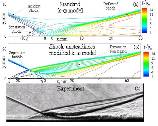
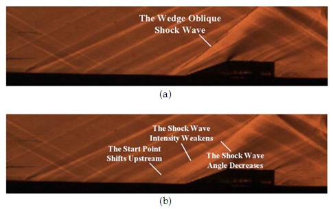
As material deposits in the separation bubble, it forms a new barrier to deflect the wind, which moves the standing shock reflection backwards into the wind. The separation bubble migrates into the wind with the shock wave, causing new dust to overlay the old in layers that stack into the direction of the wind.
The shock wave is a discontinuity in density, temperature, and ionization. Remember, we are talking about a primordial storm where much of the atmosphere ionized. So, standing shock waves formed hot plasma sheets of electric current through the air. The separation bubble is not only a pressure sink, which collects heavy matter, but is also a current sink, being the lowest potential region connected to the high potential current in the reflected shock wave. It, therefore, draws current to bake, compress, and fuse the deposited dust.
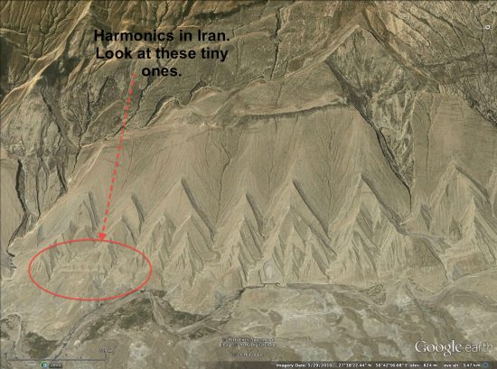
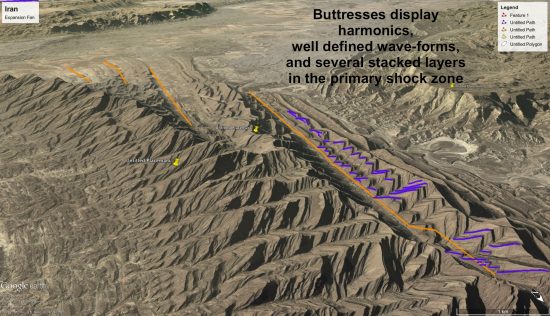
It creates a distinct pattern on the windward side. Dragon’s teeth – triangular buttresses, sometimes called flat-irons, are formed by the sonic, ionized shock waves of supersonic winds. They rise and fall in amplitude and wavelength, and display harmonic frequency shifts, as well as many, many other features which could only be produced by the sonic effects of supersonic winds — see the “Arc Blast” and “Monocline” articles for more detail.
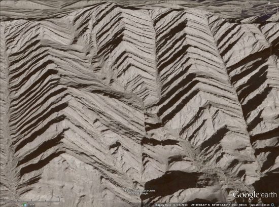
The behavior of shock waves, in particular the triangular shock patterns of compression and rarefaction they produce, is embossed on the land. It is also recorded in many ancient human artifacts, as we’ll discuss another time.
The Mexican Kink
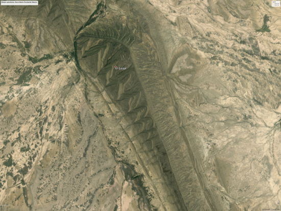
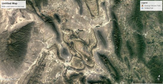
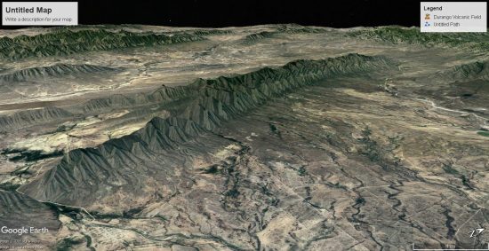
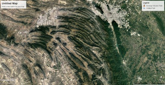
Understanding how winds form these shock patterns and examining the result on the landscape reveals a wealth of information. Let’s consider this very simple dune, called El Guaje, in the Sierra Oriental mountains of central Mexico. The shock pattern of triangular buttresses is very apparent on its windward side.
The next annotated image of El Guaje highlights four consecutively formed pressure ridges that are visible. The first (green) is almost buried by later deposition and only the tops of its buttresses are exposed. The second (yellow) is a minor ridge caused by a period of weaker winds. It is also partially buried by the third, and largest ridge (red).
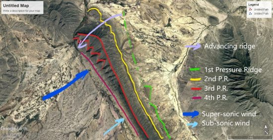
Large triangular buttresses at one end of the large (red) ridge shrink in amplitude with geometric progression until they almost vanish, indicating the jet-stream velocity transitioned from supersonic to near subsonic velocity along the wind-front of this dune. The faster jet-stream region advanced the growth of the dune, depositing material faster and pushing the shock-wave into the wind. It advanced the ridge line into the wind (violet) and built this portion of the mountain thicker, taller, with large amplitude reflected shocks forming bigger buttresses.
Each layer of the buttresses is formed by a new shock front from winds impinging on the last layer. New shock fronts formed as the winds gusted, piling new layers on the old. A final diminishing wind created a fourth shock front which deposited a small pressure ridge (purple) along the foot of the mountain. The highlights obscure natural features so please contrast all annotated images with the first, naked image.
The winds that created these ridges were like any storm, just quite a bit more violent. They stiffened as the storm grew, reached a crescendo with electrically charged, gusting blasts at Mach speeds, and then ebbed away. Their formation precludes any notion that the winds that created them were caused by meteor or comet. A large impact might produce supersonic, dust laden winds, but they would crest with the first shock wave and then dissipate, not slowly build to a crescendo.
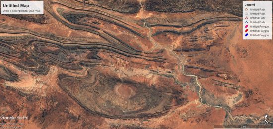
Take a look at the surroundings of El Guaje ridge, and it becomes even more apparent how it was made. It is part of a larger structure — an oblong crater, two hundred feet deeper in the center than outside the rim. The pressure ridges, including El Guaje, form the rim of the crater.
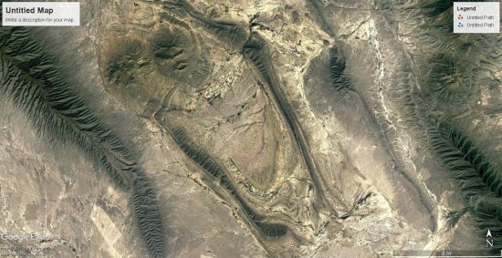
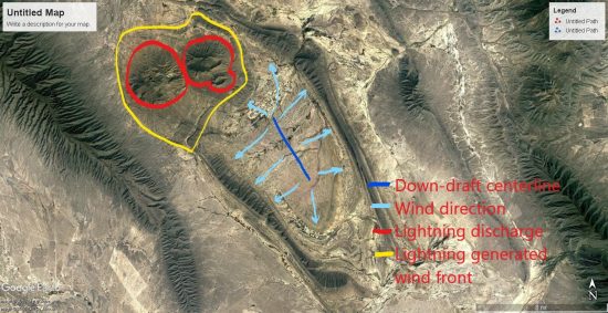
It wasn’t made by an oblong meteor. This is the result of a down-burst wind. The pressure ridges are the rims of the crater, with triangular buttresses showing the wind direction as it blasted the Earth and blew out radially, depositing dust along the standing shock waves it created. The outward blast is interfered at the top end by two, round mountains formed by lightning discharge (or intense plasma filaments) that altered the wind flow around them.
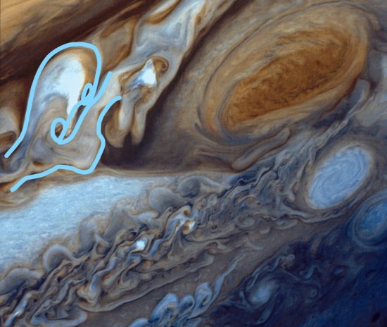
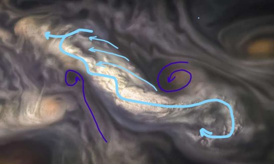
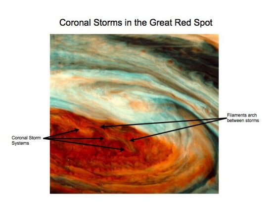
Taking another step back reveals this entire mountain region in Mexico is shaped by a turbulent shear zone in the wind that was feeding the big storm over the Colorado Plateau. These mountains were formed by the uni-polar winds, screaming from the south, and mixing into plasma storms along the shear zone with opposite polarity uni-polar winds screaming the other direction. It is eerily similar to the turbulent shear zones adjacent to the Great Red Spot on Jupiter, creating kinked circulations that have a crab-claw shape.
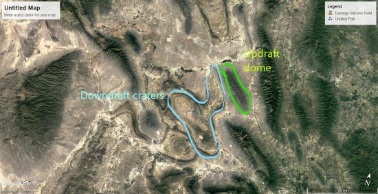
Turbulent winds fold back and forth to make these kinks, but they also fold up and down and twist into tornadoes, blowing and sucking at the land. In turbulent zones, the downdrafts form cyclones that are often stretched out-of-round into oval, polygonal, and U-shaped structures. The winds are electric currents so these turbulent kinks are semi-steady-state and keep their form for a long time, molding the land.
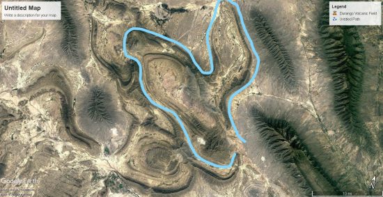
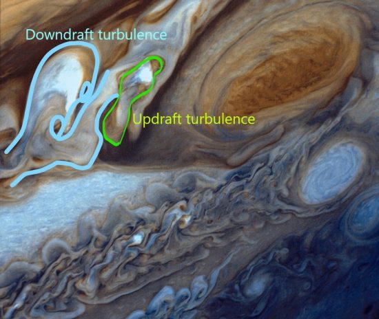
Downdraft turbulence also means updraft turbulence. So next to downdraft craters in Mexico are mountains formed by updrafts. Updraft wind will create a dome or ridge of layered deposit with a rim around it also, but the inflow to the updraft leaves triangular buttresses from shock waves on the outside of the mountain, pointing inward.
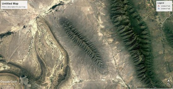
The updrafts deposit linear and lobe shaped mountains around and between the downdraft craters. The turbulence is in a shear zone so deposits occur in narrow lanes between conflicting winds. Updraft deposits are composed of more material than craters and have the triangular patterns of shock wave reflections on the flanks.
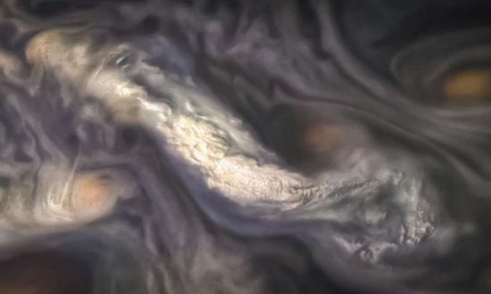
As it relates to clouds on Jupiter, a long, rising column like the one highlighted below would create such linear mountains. One can see the dark depths of the hole in the clouds from which the updraft column rises. The winds roll upward from the ground and curl over, leaving a broom-swept linear ridge on the land below.
And, of course, the juxtaposition of the updraft and downdraft features must also be considered.
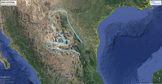
Also, the turbulent kinks in an electric circuit are fractal, so taking another step back reveals the fractal crab-claw shape emerging at a larger scale. The smaller feature with the crater shown above is nested within this larger repetition of the wind pattern shown next, aligned along the same axis. Nested fractals are very evident in Jupiter’s clouds as well.
The similarity between Mexico’s mountains and Jupiter’s clouds is due to capacitance in the planetary circuits. The strongest winds are rotating vertical winds created by the flow of electric currents. A few more examples using landforms from around the world will demonstrate this isn’t a freak local geology.
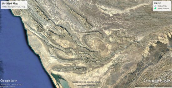
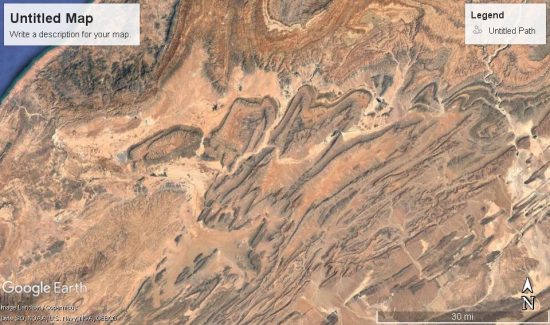
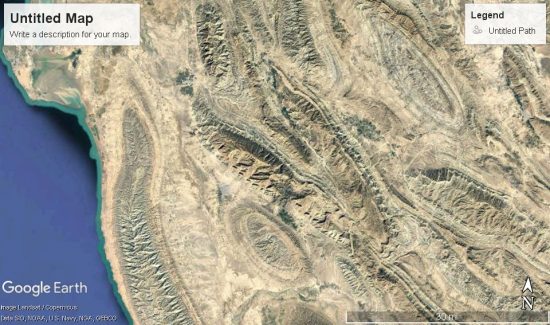
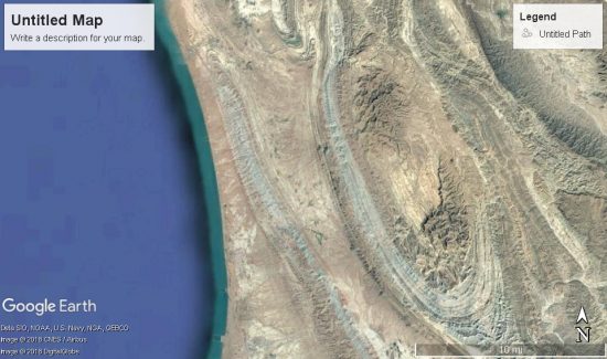
Following is a random sample taken from the southern leg of storm centers that molded South America, Australia, Africa, and Eurasia. The winds pushed and pulled on the land with electric force, literally molding it from wind action above and volcanic action below.
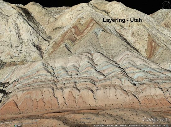
The fluid shapes are a dead giveaway for atmospheric electro-hydro-dynamic forces. But deeper levels of evidence are there, in Mach speed sonic shock effects, arcing effects, and sputtering effects that provide a holistic electric picture of everything that happened. Look close at the following images and note patterns of stratification and liquid deformation evident from waves of heat and pressure.

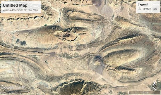
Turbulent winds lifting off the land, arcing across the sky, and returning in downdrafts were plasma currents — filaments of current that varied in charge density in cross-section. Take note how a tornado’s wind speed and density varies in cross-section with the outer wall of the tube being the fastest, most dusty region, and the inner core often a clear updraft. The plasma filaments of primordial storms varied in dust content, charge density, and velocity in cross-section as well.

The result is stratification of mineral deposits vertically, where rock morphology and mineral composition discretely change from the core of the feature, to the walls of the feature and then to the outer surroundings.
The following images show where the storm pulsed and ebbed with current, stratifying layers of dust with different dielectric composition from inside-out, where vertical up-and-down draft winds created domes and craters.
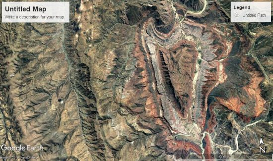
Layers of varying mineral composition are particularly evident where winds abruptly changed direction, from horizontal to vertical at the rim of craters and the buttressed flanks of mountains. There, charge densities in the shock waves and the effects of magnetic pinch were greatest.

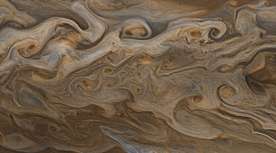
The stratification of species within the electric winds of Jupiter matches the pattern of stratification in land forms. Each up- and down-draft swirl in the clouds is layered in colors of various mixtures of vapors and dust. They are coherently layered from the inside-out of each turbulent kink, or vortex, unmixed by the turbulence, in accordance with charge densities in currents primarily moving up and down.

That electromagnetic fields sort species and recombine them is predicted behavior in plasma. We use a multitude of techniques in manufacturing based on this fact. But the electrical properties of materials is not well understood. There are new findings every day about quantum fluids, superconductivity, and the behavior of materials in phase changes. There are new material properties being discovered, like “quantum atmosphere,” the “fourth phase of water,” and materials that are surface conductive yet insulators inside. The new discoveries all have to do with electricity.
Eighty percent of Earth’s surface rock is silica. Almost any rock you pick up is mostly silica, bound with oxygen and other constituents. Each constituent, how it is bound, its percentage in the rock and local concentrations, even how large the rock is, all affect the electrical properties. Silica, oxygen, trace minerals: it’s the formula we use to produce computer chips, and the Earth’s crust is essentially made the same way.
Different materials respond to magnetic fields differently. The electric field responds to charge density so shapes itself around conductive flows of material, and vice-versa. The result is stratification, and it’s apparent the stratification on Earth’s landscapes is a match for the stratification in Jupiter’s winds.
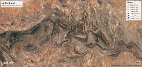
Some mountains do not conform to the wind-blown dune shape, exhibiting triangular buttresses on both flanks of the mountain, or not conforming to the windward/leeward angle of slope. This does not mean they are not dunes, but indicates they were formed subject to shifting, or competing winds.
In some cases, mountains formed as sastrugi, or linear deposits in the shear zone between laminated channels of wind of different velocity. In most cases, it is easy to distinguish the predominate ambient wind direction from the mountain flank with the most pronounced triangular buttresses, and of course, the obvious curve on the landscape.
So, it is possible by looking at the land to deduce wind patterns. Following this method, the next image shows the Colorado Plateau region with a significant number of wind formed pressure ridges annotated by blue lines. These are pressure ridges formed perpendicular to the wind. Each line is drawn parallel to the pressure ridge, and perpendicular hash marks indicate wind direction, pointing to where triangular buttresses formed. Red lines indicate sastrugi, or pressure ridges formed parallel to the wind, at the shear zone between conflicting winds.

Not every ridge line is annotated, and there is great complexity in the detail. A significant sampling of wind formed dunes in the most affected regions is presented to show large scale wind patterns generated by the storms.
These wind-blown pressure ridges show the direction of ground level winds entering and circulating in a complex fractal multi-vortex. This provides one layer of dimension to the storm. To add another layer, we can look at the signatures of updraft and downdraft winds. The North America map is rotated 90 degrees for better perspective.
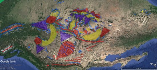
Red areas are updrafts, yellow are downdrafts, blue are precipitation footprints. There are more than can be shown without making an indecipherable collage of color, because storm(s) progressed over time and there are layers upon layers. This is a best estimate of the last layer.
Mapping the most obvious downdraft craters and updraft domes and adding this layer of information to the pressure ridges, produces a wind map of the Colorado Plateau and Rocky Mountains that looks like this:
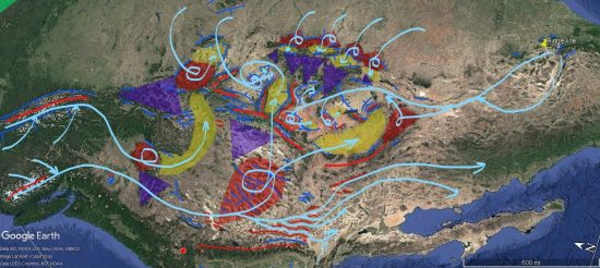
Two jet streams flowed from the north. One rose into a tight plasma mesocyclone forming Sacajewea Peak, which downdrafted through the Snake River Valley, arcing east towards Yellowstone. Yellowstone itself was erupting, creating its own rising mesocyclone. The downdraft from this storm made a dish-like crater next to it. These storms rained rock and ash from a multitude of volcanic eruptions from all along the ring of fire and Yellowstone.
The other northern jet stream swept into the largest mesocyclone in the system, rippling the great basin with rows of windblown dunes. An “S” shaped range of mountains in central Nevada defines the center of rotation, as this meso-cyclone scraped the ground as one incredible tornado. It down-drafted in two streams. One pressing down the Uinta Valley, Utah, the other sweeping northern Arizona and depositing much of the Mogollon Rim.
The Northern jet streams were wet and carried a tsunami of water, which will be discussed in future articles. Much of this water rained from the second jet stream as it rotated in the giant Great Basin tornado, leaving salt lakes between the rows of mountain range that, except for the Great Salt Lake, are now mostly dry.
The Great Basin tornado also spun air south, bypassing the rotation to help define the Sierra Mountain arc, and scoured deep valleys between tall linear ranges, forming Owens, Amorgosa, Saline, and Death Valley. The Sierras formed by winds from the west (not shown) that pressed against the Great Basin rotation and the winds bypassing south.
From the south, winds collected and then split, forming the Mexican Kink and the El Guaje mountain. They reformed in a ground-hugging laminar flow near Four Corners, sweeping across Colorado, Utah, and northern Arizona, laying down the foundations of the Colorado Plateau.
The main attractors for this wind were two coronal loops, one rising into a mesocyclone at San Rafael Reef and down-drafting into a mirror image crater defined by Capitol Reef in Utah. The other rising at Monument Valley, its shock wave defined by Comb Ridge, Arizona and down-drafting due south to rejoin the general counter-clockwise rotation over the Plateau in the region bordered by the San Juan River.
Winds from the south also circulated eastward over the Great Plains to be sucked into the Colorado Plateau cyclone through a row of coronal loops that built the eastern face of the Rockies. These down-drafted into tight cyclones, forming huge craters in the mountains, like San Luis Valley, Colorado.
Each of these features — the large Great Basin mesocyclone, the tightly wound cyclone over the Colorado Plateau, and the arching colonnades of coronal loops within the bigger cyclone which feed it, like thunderstorms feed a hurricane. It’s all the same fractal-ing thing.
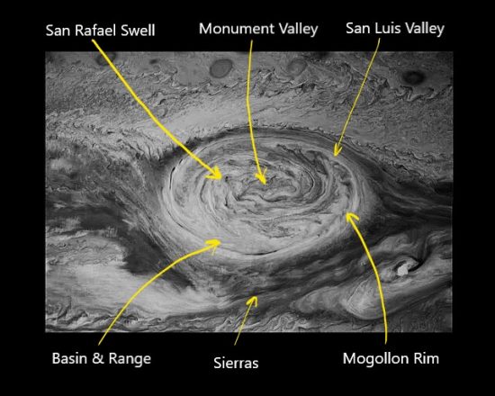
So this completes the view of winds at the very eye of the storm. The Monument Valley and San Rafael Swell coronal loop storms caused the largest potential difference and hottest plasma torching in North America. Surrounding areas were also ravaged by storm but none so severely. In fact, the whole Earth was wrapped in storms. So, we’ll look closer at some of those regions, as well as more details on North America in the next instalment of Eye of the Storm.
Additional Resources by Andrew Hall:
YouTube Playlists through 4-2022:
Andrew Hall — EU Geology and Weather
Andrew Hall — Eye of the Storm Episodes (13)
Surface Conductive Faults | Thunderblog
Arc Blast — Part One | Thunderblog
Arc Blast — Part Two | Thunderblog
Arc Blast — Part Three | Thunderblog
The Maars of Pinacate, Part One | Thunderblog
The Maars of Pinacate, Part Two | Thunderblog
Nature’s Electrode | Thunderblog
The Summer Thermopile | Thunderblog
Tornado — The Electric Model | Thunderblog
Lightning-Scarred Earth, Part 1 | Thunderblog
Lightning-Scarred Earth, Part 2 | Thunderblog
Sputtering Canyons, Part 1 | Thunderblog
Sputtering Canyons, Part 2 | Thunderblog
Sputtering Canyons, Part 3 | Thunderblog
Eye of the Storm, Part 1 | Thunderblog
Eye of the Storm, Part 2 | Thunderblog
Eye of the Storm, Part 3 | Thunderblog

Andrew Hall is a natural philosopher, engineer, and writer. A graduate of the University of Arizona’s Aerospace and Mechanical Engineering College, he spent thirty years in the energy industry. He has designed, consulted, managed, and directed the construction and operation of over two and a half gigawatts of power generation and transmission, including solar, gasification, and natural gas power systems. From his home in Arizona, he explores the mountains, canyons, volcanoes, and deserts of the American Southwest to understand and rewrite an interpretation of Earth’s form in its proper electrical context. Andrew was a speaker at the EU2016 and EU2017 conferences. He can be reached at hallad1257@gmail.com or thedailyplasma.blog
Disclosure: The proposed theories are the sole ideas of the author, as a result of observation, experience in shock and hydrodynamic effects, and deductive reasoning. The author makes no claims that this method is the only way mountains or other geological features are created.
The ideas expressed in Thunderblogs do not necessarily express the views of T-Bolts Group Inc. or The Thunderbolts Project.