Some storms suck and others blow…
By Andrew Hall
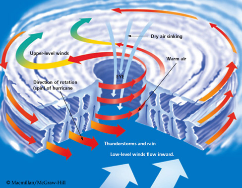
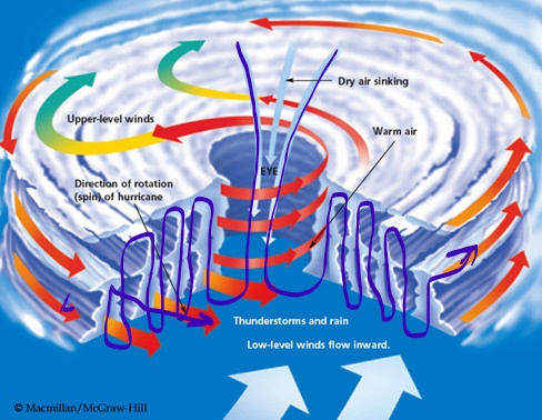
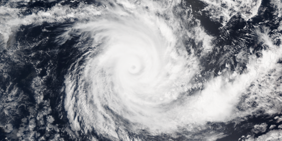
On Earth, hurricanes and typhoons are called cyclones and occur over the oceans. The cyclonic storm develops an eye in the center of rotation, where high altitude, dry air is drawn down the center. The thing to know is that the eye of a cyclone is a downdraft wind.
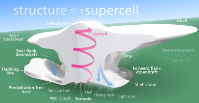
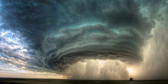
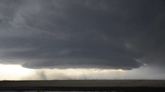
Over land, we see a different effect. Super-cell thunderstorms develop a rotating mesocyclone that rises in a tower and spreads an anvil cloud. The thing to know is that the center of a thunderstorm is an updraft wind.
If you look at these different storms from above, the cyclone blows at the ground, and the thunderstorm sucks at the ground. The pattern of wind in each type of storm is due to capacitance in the electrical circuitry of the Earth.
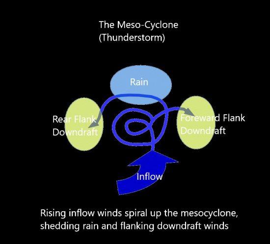
The thunderstorm as a circuit…
The electric winds of a thunderstorm can be likened to a rope. Generally, the rope winds up the towering mesocyclone to a cap, the anvil cloud, and unwinds from there to non-rotating channels of rain flanked by downdraft winds.
The very pattern of a super-cell betrays its identity. It is a stack of dielectric layers through which a current flows. Condensing and then freezing moisture in the updraft sheds ionized matter into cold plasma currents that produce rain, lightning, and tornadoes.
A massive, cold plasma halo in the sky acts like a live electrode hanging over the ground with an air gap between. The updraft current is from ions swept from ground level. It loops through a negative plasma low in the cloud where condensation occurs and continues to a positive plasma in the anvil where ice forms. At each level, the recombined matter — the rain and ice — are shed and return to ground. Flanking down-draft winds are excess currents of uni-polar wind that complete the storm’s looping circuit to ground.
Three Dimensional Jet Streams
Charge densities are responsible for the geometry of storms. As negative charge builds in the bottom, wet layers of cloud, it strengthens the local electric field and draws winds to it. Above, in the cold icy layers at high altitude, a positive layer of charge accumulates to balance the charge below, and it spreads out in a huge disc.
Likewise, on the ground below the cloud, positive charge accumulates to balance the cloud charge and feed the central updraft. Lightning arcs contribute to balancing the charged layers, dissipating charge at points of highest potential.
But the build-up of charge density around the core of the storm also means there is a secondary vector in the electric field running horizontally through the cloud layers. As ionic matter is drawn to the storm by updraft and concentrated, it depletes charge from the far field region of atmospheric layers, creating local electric fields which draw current horizontally, transverse to the electric field at the core of the storm.
Charge diffuses horizontally as well as vertically, and the visual evidence is in the symmetry and coherence of the tightly wound mesocyclone. The base of the storm which draws charge to it — and the spreading anvil cloud which disperses charge away.
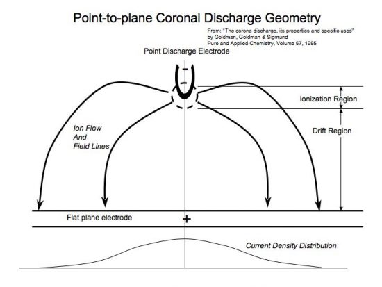
Everything about thunderstorm morphology speaks to layers of capacitance in a point-to-plane circuit that loops through an air gap to ground.
Consensus science has attributed the electrical charge build-up in thunderstorms to “static” charge from colliding rain and ice. One flaw in this idea is: there is nothing static anywhere, at any time, in any place in a thunderstorm. Everything moves — and that means charge, too, which means one undeniable thing: electric current. To not model a thunderstorm as such flies in the face of reason.
Fractal Progression
In a hurricane, the airflow is very different from a thunderstorm. Consider the wind-flow again as a piece of rope: the rope enters whole down the central vortex, and unwinds into several threads of vertical up-and-down drafts flowing radially away from the storm’s eye in rotating currents.
It’s almost the inverse of a thunderstorm, which has a rotating updraft that unwinds into threads of non-rotating downdrafts and rain.
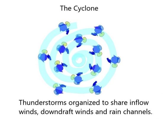
The cyclone’s rotating updraft bands are made of thunderstorms, which electrically suggests the entire cyclone is a next-level fractal expression of the thunderstorm. The independent loops of thunderstorms maintain their form but have organized together creating loops within loops, and vortexes within vortexes — fractal repetition of form.
In fact, thunderstorm cells interact as looped currents all the time, even when not part of a larger cyclonic system. One storm cell can arch its anvil cloud over another, and suck the life out of it by absorbing its energy. One can witness this as squall lines of thunderstorms develop.
Comparing the characteristics of thunderstorms and hurricanes (northern hemisphere) shows the similarities and polar opposite characteristics that naturally develop in this fractal progression:
| Attribute | Thunderstorm | Hurricane |
| Surface Condition | Over land | Over ocean |
| Central Core Wind | Wet, hot, rotating updraft of condensation | Dry, cold, non-condensing, non-rotating downdraft |
| Outer Winds | Non-rotating, dry downdraft winds flanking a rain curtain | Circumferential rotating wet updraft winds and rain bands |
| Rotation | Counter-clockwise central updraft mesocyclone, wall clouds and tornadoes rotate in the core of the storm | Counter-clockwise, outer winds and rain bands rotate around the central downdraft core of the storm |
| Discharge modes | Vertical winds, lightning and tornadoes | Rotating wind. Cyclones produce very little lightning and comparatively weak tornadoes. |
In a hurricane, thunderstorms organize like synchronized swimmers swimming in a circle, creating a whirlpool down-draft in the center. The organized entity has more power than a mesocyclone, but it’s diffused over a greater area and creates less tension in the electric field.
Super-cell thunderstorms are small in comparison to cyclones but create a higher electrical tension that produces far more lightning and powerful tornadoes.
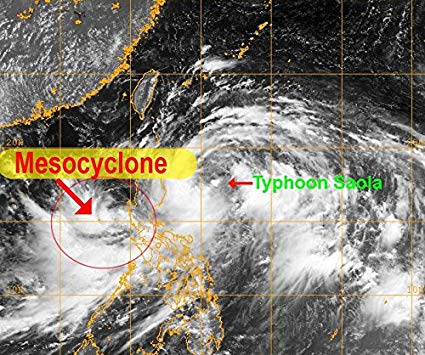
One reason a cyclone is different from a mesocyclone is that cyclones form over water. The electrode spot on a featureless, homogeneous surface of ocean diffuses charge broadly and evenly. On land, there are mountains, mineral and water deposits that ‘focus’ the electric field, by providing greater conductivity or increasing charge density at elevations.
A similar relationship exists between thunderstorms in mountain regions and the super-cells on the plains that produce horrendous tornadoes. Mountainous regions rarely produce tornadoes because high points and mineral deposits collect charge, increasing the electric field tension to draw arcs of lightning. The diffusion of ground charge on flat plains allows discharge between ground and cloud to spread out, which favors spinning Marklund plasma currents instead of intense bolts of lightning. The tornado is a more diffused, slower, less intense discharge than a lightning bolt but still a fractal element of discharge within the thunderstorm.
The cyclone is a fractal step-up in scale from the mesocyclone. It isn’t just a bigger thunderstorm; it’s a whole new entity composed of the old entities, re-organized into a higher level of complexity. It’s like striking one octave above a note and finding harmony — two notes in resonance that create a new sound, more complex than the sum of each note.
The cyclone is the next level of storm complexity. Here the thunderstorm cells act in harmony and begin to share lanes of updraft and downdraft winds, manifolding together and developing a coherent rotation. Ultimately this forms an eye with a downdraft in the center, and a cyclone is born.
But a cyclone is not the most powerful level of fractal progression for storms on Earth. When a cyclone and mesocyclone organize, the next fractal level of plasma is formed. This creates the most destructive storms of all, at least that we see today.
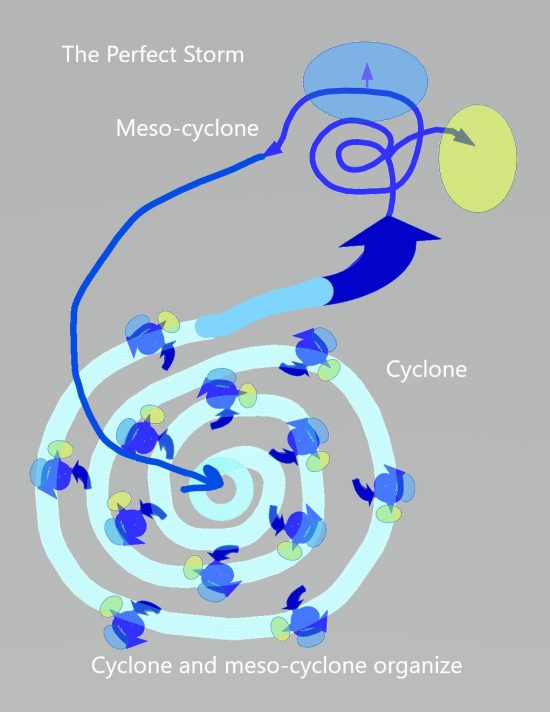
In our historic period, we don’t see storms that exceed the level of the so-called “Perfect Storm”, like the famous book of that name, which described the last voyage of a fishing boat caught between such storms, where a hurricane and nor’easter met.
When mesocyclone and cyclone come together, they produce a loop current. It’s a fractal progression of the thunderstorm current — updraft to downdraft and rain. Only one big mesocyclone connected to a cyclone makes one big current. Outflow at ground level from the cyclone feeds the mesocyclone, and discharge from the high-level anvil feeds the cyclone’s eye. Coherency emerges from plasma actions expressed at every level of the storm in greater and greater complexity.
In our present climate on Earth, “The Perfect Storm” is as bad as it gets. But we are only seeing an echo of the drama of primordial storms. Even though we see lightning and devastating three hundred mile-per-hour winds — violent enough to destroy our matchstick homes — it does not scour us with supersonic winds, hot plasma tornadoes, and electric arcs that shape mountain ranges.
But it did, at some point long ago. Updraft winds of mesocyclones and downdraft eyes of cyclones became supersonic jet-streams. An energized geomagnetic field amplified the magnetic flux in coronal loops generating co-rotating storms that sucked and blew at the land, leaving vast craters and domes. The ring currents multiplied, too, generating smaller harmonic repetitions — more intense fractal repetitions that produced hot, probably glowing plasma tornadoes and incredibly huge arcs, large enough to boil a mountain from the earth.
As fractal evolution progresses with the application of a larger electric field, thunderstorm cells multiply and their downdrafts grow to cyclones, until multi-vortex systems spin within multi-vortex systems, which are within a multi-vortex system. Nested fractal repetition of form.
We sense winds as horizontal. We describe them that way: nor’easter, westerly, windward, and leeward. We rarely think of vertical winds unless we are right under them, and then it is considered an unusual and often catastrophic event. Down-bursts, tornadoes, and related vertical effects, lightning and storm surge are the most destructive elements of storms. Vertical winds impact smaller regions but are far more violent than horizontal winds.
In primordial storms, vertical winds literally blow-torched the land, and sucked at it like a vacuum hose. We can see this in the geology.

The Solar Example
Strip away the hydro-dynamics of a dense atmosphere, fully ionize the environment to see the raw electric currents in a hot plasma, and it’s like an x-ray view of a storm.
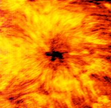
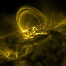
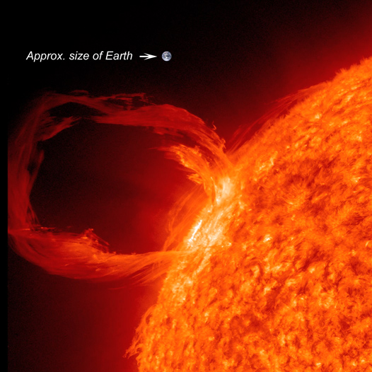
Sunspots are Solar hurricanes. The central core is a downdraft wind diving beneath the chromosphere. The filaments radiating from the core are coronal loops, attached at one end to the core, and the other to plasma “thunderstorms” — the updraft leg of the loop, which is positioned in a circumferential ring around the core, feeding it filaments of current.
Coronal loops are current discharges along magnetic field lines feeding the core downdraft of a sunspot. The loops are currents trying to break through the Solar atmosphere. When they do break through, it becomes a Solar flare.
Capacitors are used in electronics and power supply systems to control current flow. They are composed of two conductive plates facing each other with a gap between. The gap is filled with a dielectric material that resists current flow. In its intended operation, current does not pass through the dielectric. Current results from charge build-up and discharge from the plates on either side of the gap.
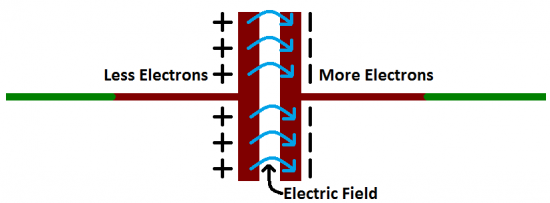
The hows and whys of a working capacitor are fascinating, but what we are interested in for this discussion is how a capacitor fails. A capacitor fails when current actually flows through the dielectric. It’s termed dielectric breakdown and occurs when the voltage applied to the capacitor exceeds its capacity to store charge on the plates. The dielectric fails to resist the electric field across it and it sparks. That is what we see when lightning strikes — the dielectric breakdown of the layer of air between a cloud and ground. An ionized channel develops in the dielectric and the built-up charge on the plates suddenly dumps through the channel.
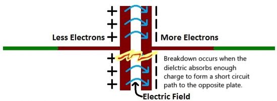
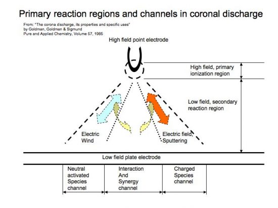
We see the discharge as almost instantaneous but in reality, there is a prior period when the dielectric absorbs charge and builds the ionized channel. Charge has to diffuse through the dielectric before the channel forms and connects the plates. The diffusion of charge through a spherical capacitor, like the Sun’s atmosphere, creates current loops within the dielectric. As charge is absorbed by the dielectric, it forms currents that loop from one plate into the dielectric and back to the same plate because they have no path yet to reach the other plate.
As voltage increases, the loops grow (absorption) extending the ionized path further and further until it breaks through the atmosphere and discharge occurs.
In storms on Earth, the same looping current flows are in the form of weak plasma winds because the atmosphere is only partially ionized. Cold plasma is mixed with neutral species, so thermo-electric and hydro-dynamic effects come into play, raising complexity, but the underlying electric circuit is the same.
On Jupiter, the same electrical process can be seen occurring, and current loops, or coronal loops can be identified in the Great Red Spot. They appear as Roman colonnades of arches in the cloud, which rise in towering pillars, arch across the sky, and downdraft into the eye of doughnut-shaped cyclones.
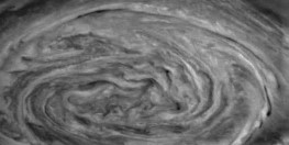
The arching clouds portray the current loops in a multi-vortex coronal storm. They march around the inner rotation the way thunderstorms circulate the eye of a hurricane. Each doughnut-shaped cloud at the base of an arch is a cyclone of giant proportion with a downdraft through its core. The other end of the arch is the towering updraft of a thunderstorm, and the filament that arches between is the anvil cloud following current flow along a loop connected to a dielectric surface below. They are the tops of vertical ring currents — coronal loops — that are so intense they sculpt the anvil clouds in the shape of the current flow.
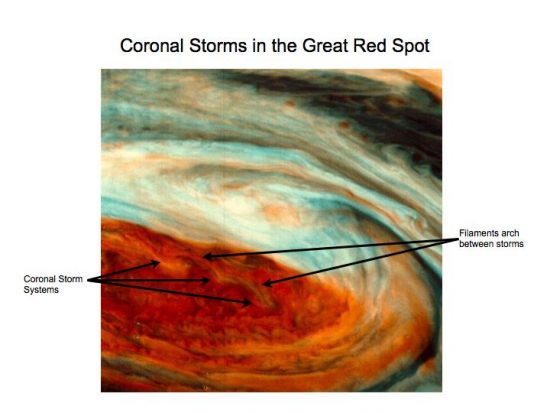
NASA can detect these jet stream winds. They are aware of the complex patterns and the violent up and down drafts in the Great Red Spot. Unfortunately, they don’t understand electricity, and so are scratching their heads over the obvious.
The colorized NASA images shows two rows of updraft/downdraft loops riding along the outer circulation of the red region. The entire red region is the giant hurricane with concentric rings of thunderstorms. At the bottom of the red region, the pattern of a double row of arching clouds continues but the arches are stretched by the rotation of the entire system.
Above the red region is a white shelf cloud that itself has a single, large, counter-clockwise rotation. This is the anvil cloud of a singular giant thunderstorm, and together with the giant cyclone, form one ultra-large “Perfect Storm”.
On Earth, at ground level, these kind of looping currents of cyclone/mesocyclone produced supersonic updraft and downdraft winds that created domes and craters on the land. The jet-stream winds rode up and down these current loops like a yarn crocheted, up and down, through and around, but always folding into an ambient rotation counter-clockwise.
So, with this in mind, in the next installment of Eye of the Storm, we’ll look at a wind map of North America and see the evidence of Earth’s electric winds.
Additional Resources by Andrew Hall:
YouTube Playlists through 4-2022:
Andrew Hall — EU Geology and Weather
Andrew Hall — Eye of the Storm Episodes (13)
Surface Conductive Faults | Thunderblog
Arc Blast — Part One | Thunderblog
Arc Blast — Part Two | Thunderblog
Arc Blast — Part Three | Thunderblog
The Maars of Pinacate, Part One | Thunderblog
The Maars of Pinacate, Part Two | Thunderblog
Nature’s Electrode | Thunderblog
The Summer Thermopile | Thunderblog
Tornado — The Electric Model | Thunderblog
Lightning-Scarred Earth, Part 1 | Thunderblog
Lightning-Scarred Earth, Part 2 | Thunderblog
Sputtering Canyons, Part 1 | Thunderblog
Sputtering Canyons, Part 2 | Thunderblog
Sputtering Canyons, Part 3 | Thunderblog
Eye of the Storm, Part 1 | Thunderblog
Eye of the Storm, Part 2 | Thunderblog

Andrew Hall is a natural philosopher, engineer, and writer. A graduate of the University of Arizona’s Aerospace and Mechanical Engineering College, he spent thirty years in the energy industry. He has designed, consulted, managed, and directed the construction and operation of over two and a half gigawatts of power generation and transmission, including solar, gasification, and natural gas power systems. From his home in Arizona, he explores the mountains, canyons, volcanoes, and deserts of the American Southwest to understand and rewrite an interpretation of Earth’s form in its proper electrical context. Andrew was a speaker at the EU2016 and EU2017 conferences. He can be reached at hallad1257@gmail.com or thedailyplasma.blog
Disclosure: The proposed theories are the sole ideas of the author, as a result of observation, experience in shock and hydrodynamic effects, and deductive reasoning. The author makes no claims that this method is the only way mountains or other geological features are created.
The ideas expressed in Thunderblogs do not necessarily express the views of T-Bolts Group Inc or The Thunderbolts ProjectTM.