Photo Credit: International Space Station
The Maars of Pinacate, Part One
By Andrew Hall
El Pinacate y Gran Desierto de Altar is a geologic wonderland for volcanologists. It should also be a laboratory for study of the Electric Earth. Pinacate is a monogenic volcanic field in Sonora, Mexico that lies just south of the Arizona border, seventy miles east of where the Colorado River empties into the Sea of Cortez. It is a protected Biosphere Reserve and World Heritage site.
Monogenic volcanic fields, meaning each eruptive feature in the field is the product of a single, short eruption of unique magma, are not uncommon in North America. In fact, Pinacate is one of fifty that dot the landscape from central Mexico to Colorado. What makes Pinacate special is its pristine nature, for it is largely untouched by human hands or the effects of severe erosion.
 Its location in the desiccated Altar Desert of Sonora is the reason it has remained pristine. As Edward Abbey wrote of the Altar: “This region is the bleakest, flattest, hottest, grittiest, grimmiest, dreariest, ugliest, most useless, most senseless desert of them all. It is the villain among badlands, most wasted of wastelands, most foreboding of forbidden realms.” In other words, it was one of Abbey’s favorite places.
Geologists insist Pinacate is dormant, but recently so. Its last eruption is dated a mere ten thousand years ago. But local lore of the Tohono O’odham people, descendants of the ancient Pueblo culture known as Hohokam, insist there have been two minor eruptions in the last century, one in 1928, and again in 1934. Seismographic records don’t bear this out, say geologists, indicating no seismic event associated with volcanic activity was recorded at the time.
 Its many lava flows and tephra beds portray the Pinacate as the result of three volcanic periods. First, it developed as a shield volcano, raising the mountain that gives the field its name.
Pinacate is derived from the Aztec word for black beetle and is commonly used for the desert stink bug. Identity with the mountain is understandable since stink bugs hold their rear high and emit a foul odor.
The next period brought blooms of pyroclastic eruption that left over five-hundred volcanic vents and cinder cones across 770-square-miles.
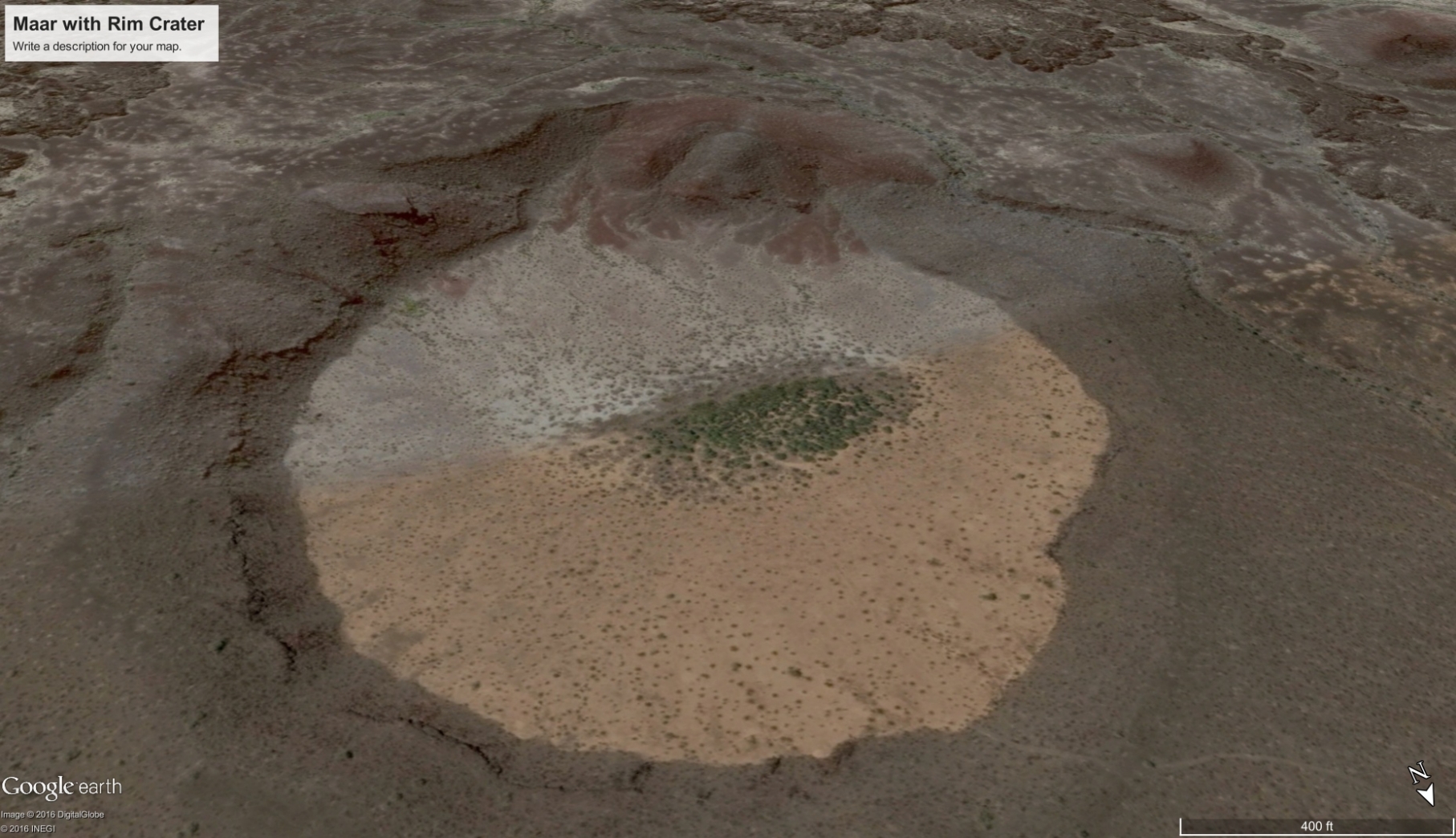
Its final phase created several maar craters. The Pinacate is best known for maars and the rings of tuff they create. There are about a dozen maars and tuff-rings in the Pinacate.
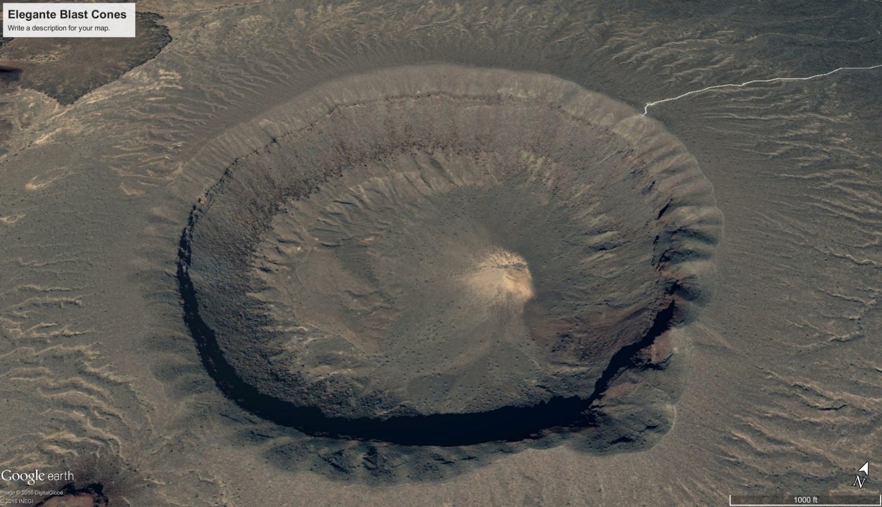
The crown jewel is El Elegante. One mile in diameter, with steep sides sloping to a depth of 800 feet, it looks like a giant bottle cap was pressed into the earth to leave this depression. Its size, symmetry, and scalloped edges earn ‘The Elegant One’ its name.
Maars are one expression of a diatreme volcano. Their creation is brief and explosive. Magma rises beneath moisture held in an aquifer, sub-surface stream, or permafrost, and vaporizes the water in a series of blasts that last from a few hours to several weeks. A shallow crater with a bowl floor and a low raised rim are left, over a rock-filled fracture called a diatreme. Typically, maars fill with water following an eruption, leaving a lake. The maars of Pinacate are dry and accessible.

No certainty as to formation is truly known in consensus science. The inverted cone shape of a maar diatreme has been generally assumed to form by shallow explosions first, followed by progressively deeper explosions.
The explosions are thought to be caused by the explosive vaporization of ground water when it contacts hot magma. If deep explosions occurred first, they would hollow out a wide void, not a conical vent.
But the shallow-first theory should produce ejecta of shallow rock covered by later deposits of deeper rock. Examination of maars shows that deep rock fragments are well mixed with shallow rock, implying explosions occurred throughout all depths at once.
Geologist Greg Valentine, a professor at the University at Buffalo in New York, and James White, an associate professor at the University of Otago in New Zealand, have created a new model to account for the jumbled order of explosions. Their model, published online Sept. 18 in the journal Geology, suggests individual explosions are relatively small, and shallow explosions are more likely to cause eruptions than deep explosions.
The model did not include subsurface electrical discharge as a possible causation. Perhaps it should.
The likeness of Pinacate’s craters to Lunar craters made it a perfect training ground for Apollo astronauts. It’s also a reason the area should be of interest to the study of Electric Earth phenomena. Close inspection of craters and other features in Pinacate reveals more than a casual resemblance to the craters of the Moon. Let’s take a look.
Rim Craters
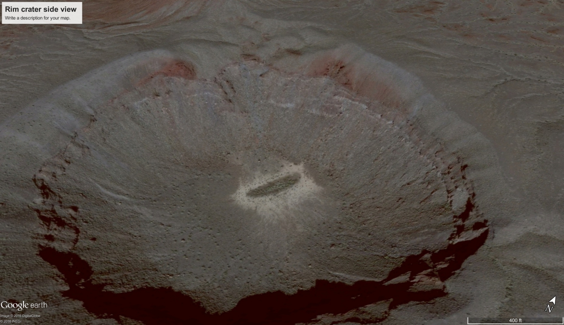
Beginning with El Elegante, the Google Earth image below shows a rim crater at the four-o’clock position — the only flaw in its beautiful symmetry.
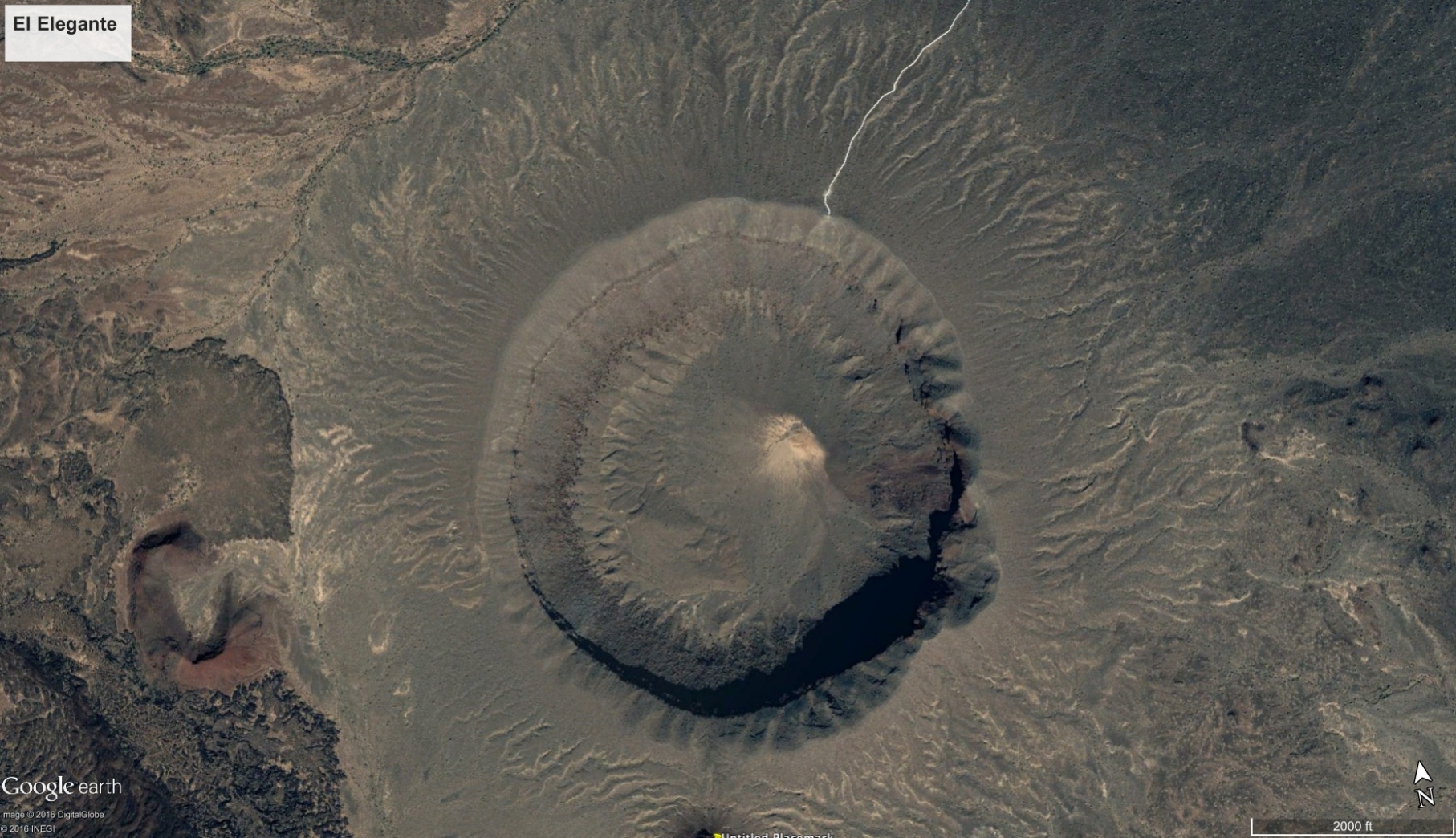
Top View of El Elegante

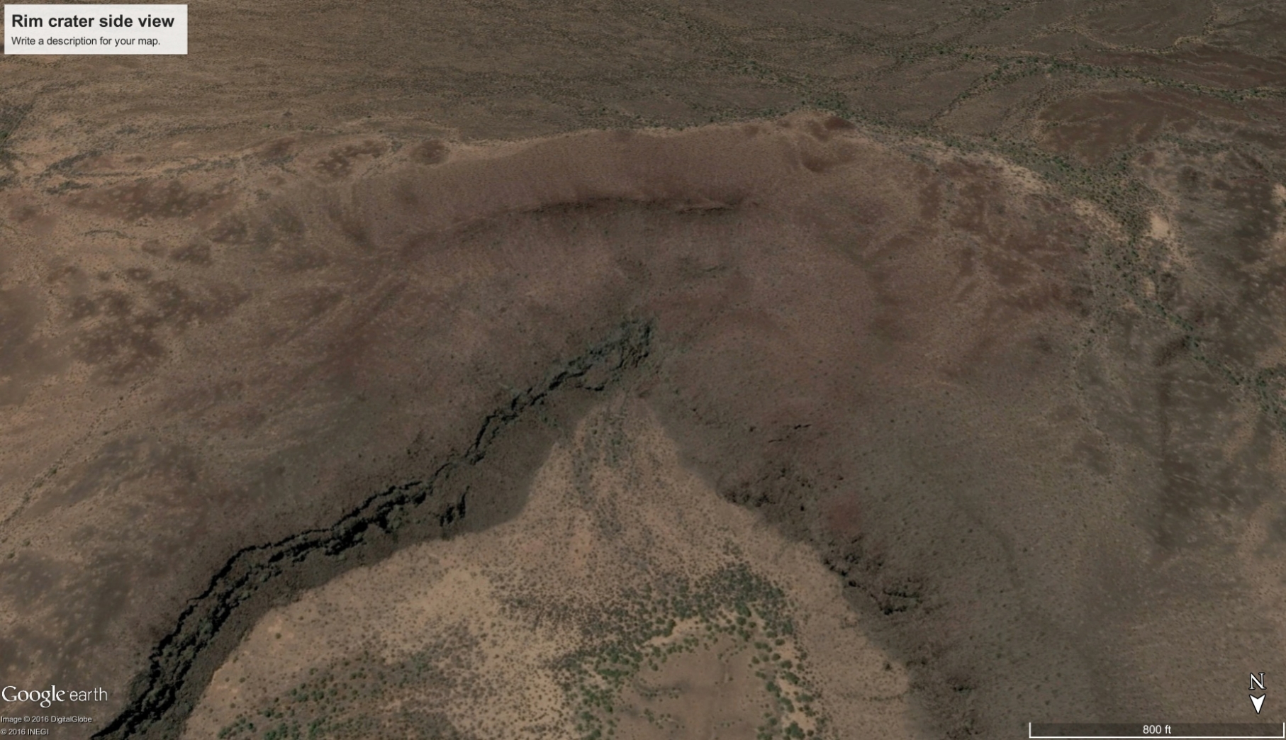
Side View of Rim Crater
It is explained as an older cinder cone that was split in half by the maar eruption.
Rim craters also occur on other maars in the Pinacate. In fact, more than half of the maars have features that appear to be rim craters. Perhaps it is normal for maars to occur at the edge of older volcanic vents — perhaps the older vent plays a role in creating the maar. Or they may be what they look like, a feature caused by a filament of electrical discharge.
Rim craters occur with such regularity on rocky bodies in our solar system it is statistically absurd to think they are caused by chance impacts. They are a known feature of electrical discharge, as filaments of spark will form craters within craters, and often ‘stick’ to the rim of a crater previously formed, leaving rim craters.
The maar below is 0.9 miles wide and 250 feet deep. It also displays scalloped edges and a large rim crater at the five-o’clock position. Another small rim crater is at the nine-o’clock position (all overhead images are oriented with North up, at the 12-o’clock position).
Most confusing, assuming the consensus science view of how maars are created, is the small tuff-rings in the floor of the crater beneath the large rim crater. In this case, the rim features can’t be the remnant of an older cinder cone since they could not possibly have pre-existed the maar eruption. It must be the remnant of events that followed the sequence of eruptions that made the maar — but where is the debris from this later event?


Side View of Rim Crater
This maar, 2400 feet in diameter by 50 feet deep, at half-past six o’clock, has three at six o’clock craters blanketed by an inflow of red ash, as if the event flattened the cinder cone next to it by pulling it in.

The next images show a rim crater at six-o’clock in a primary crater that is 2,600 feet in diameter by 150 feet deep. The triangular wedge is actually a slice from a pie-shaped depression at the rim.

The next images are of a maar 3400 feet in diameter by six hundred feet deep. It shows a rim crater at eleven o’clock. Gray ‘ejecta’ blankets the rim crater. But the side view shows the rim crater has a steep, conic depression below the gray material.
The gray ejecta is obviously associated with the maar and blankets the slopes and lava flow of the red cinder cones nearby. This appears to be the case with the other maars, indicating they occurred in the latest series of eruptive events. However, the question should be asked whether the material was blown-out, or sucked-in by the event that made the crater.

The gray blanket is formed into dunes (see top center of photo above). Dunes exhibit a gentle slope to windward, and a steep reverse slope to leeward, suggesting at least the final winds of this dramatic event were directed inward to the crater.
Cerro Colorado

The lopsided rim of Cerro Colorado
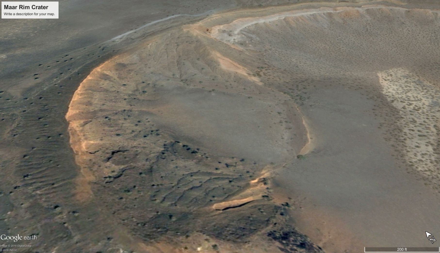
Large rim crater at Cerro Colorado
The best example of a rim crater in the Pinacate is Cerro Colorado. Thought to be the result of multiple blasts through several vents, the main crater is 3200 feet across with a canted rim. The lopsided rim is thought to have been created by prevailing wind depositing ejected material preferentially to the south, or because subsequent explosions caused the north side of the rim to collapse, depending on which consensus theory is chosen. Neither provides a satisfactory explanation of the rim’s appearance.
On closer look, it could also be interpreted that material was drawn in, the way a tornado draws ground winds to it, to create the lopsided rim. The neat, even edges and compact symmetry of the aureole around the rim appear to be caused by inflowing winds rather than several explosive outward blasts.

Rim Crater is at 11 o’clock
In the next image, along the crater rim can be seen layers of deposition, consistent with the effects of winds being drawn inward to the crater.

The Electric Volcano
There is no question that Pinacate is a volcanic field. The lava flows, ash and tuff attest to that. We see active volcanoes around the world. The Ukinrek eruptions on the Alaska Peninsula in 1977 created two maar craters.
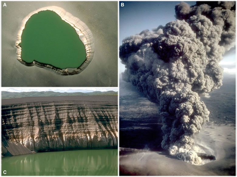
Ukinrek Eruption, Photo Credit: USGS
The largest of these maars, now filled with water to form a lake, erupted for ten days to create a crater 1,000 foot wide. Photos above show the eruption and resulting maar.
The largest Pinacate maars are one mile in diameter. The largest known maar on Earth is on Alaska’s Seward peninsula and is five miles wide. The magnitude of the Pinacate and Seward Peninsula events dwarf the Ukinrek, or any other eruptions seen in historical times.
Consensus science does not explore the electrical nature of volcanoes, and the potential effects of an intensified electric field. They should be interpreted with electromagnetic effects in mind to understand them fully.
In this article, we’ve looked at the physical similarity of Pinacate’s maars to Lunar craters, including the distinctly electrical appearance of rim craters. Lunar craters are believed by consensus science to be formed by impacts. Pinacate’s craters are a known volcanic event. Could it be their similarity isn’t coincidence, but commonality of cause; that cause being electricity? In “The Maars of Pinacate, Part Two, we’ll look at more similarities and expressions of electrical scarring.
Additional Resources by Andrew Hall:
Andrew Hall YouTube Playlists through 4-2022:
Andrew Hall — EU Geology and Weather
Andrew Hall — Eye of the Storm Episodes (13)
Surface Conductive Faults | Thunderblog
Arc Blast — Part One | Thunderblog
Arc Blast — Part Two | Thunderblog
Arc Blast — Part Three | Thunderblog
Andrew Hall is an engineer and writer, who spent thirty years in the energy industry. He was a speaker at the EU2016 conference and can be reached at hallad1257@gmail.com or https://andrewdhall.wordpress.com/
Disclosure: The proposed theory of arc flash and arc blast and their effects on the landscape are the sole ideas of the author, as a result of observation, experience in shock and hydrodynamic effects, and deductive reasoning. Dr. Mark Boslough’s simulation of an air burst meteor provided significant insight into the mechanism of a shock wave. His simulation can be viewed on YouTube: Mark Boslough. The author makes no claims that this method is the only way mountains or other geological features are created.
The ideas expressed in Thunderblogs do not necessarily express the views of T-Bolts Group Inc or The Thunderbolts ProjectTM.