
home •
about •
essential guide •
picture of the day •
thunderblogs •
news •
multimedia •
predictions •
products •
get involved •
contact
picture of the day archive subject index
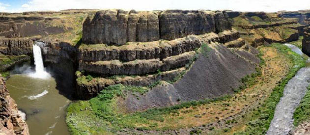
Palouse Falls, Eastern Washington. Photographer unknown.
Jun 18, 2008
The Channeled ScablandsSome researchers have theorized that hundreds of megafloods in a cycle ranging over thousands of years formed the scars in Washington State. Electricity could have carved the region in minutes.
On September 20, 2005, National Public Broadcasting sponsored a NOVA television documentary, “Mystery of the Megaflood.” The program elucidated a theory for how Eastern Washington State was scoured down to the bedrock, leaving formations that geologists find difficult to explain from a uniformitarian perspective. Rather than relying on traditional models of slow, progressive erosion, a catastrophic hypothesis was proposed.
As the theory suggests, during the end of the last ice age, approximately 12,000 years ago, a flood of water taller than mountains swept down through valleys and drainage channels, moving at 120 kilometers per hour. The force of the water was so great that it washed away the forests, the topsoil and any signs of civilization that might have existed in its path. Nothing remained except humps of basalt lava, dry canyons, waterfalls that today have no water and deep chasms that mark where the colossal flow etched into the rocks.
NOVA based their program on a theory originally published by J Harlen Bretz in 1925. It was Bretz who referred to the area as The Channeled Scablands because he thought that mounds of dolerite scattered throughout the Grand Coulee territory resembled crusty scabs on the flat plain. Along with fellow geologist J.T. Pardee, Bretz became convinced that the Columbia River Plateau has been the scene of not one but hundreds of floods that periodically erupted from a now dried up lake that collected behind a glacial dam.
Bretz proposed that a glacier blocked the mouth of an ancient river valley and the runoff from melting ice gradually filled it with water, forming what is now known as the extinct Lake Missoula. As the water grew deeper – theorized to be nearly 300 meters deep – the pressure on small cracks in the ice dam forced it to crumble and fail all at once, discharging as much as 60 cubic kilometers of water per hour out over the landscape.
Bretz and Pardee formulated their theory of flooding because the prevailing opinions among scientists of their day did not seem to fit the observations that they made in the field. The two researchers conducted extensive surveys throughout Oregon and Washington, finding anomalous terrain and evidence that seemed to demand an alternative to the gradualism on which their scientific discipline was based.
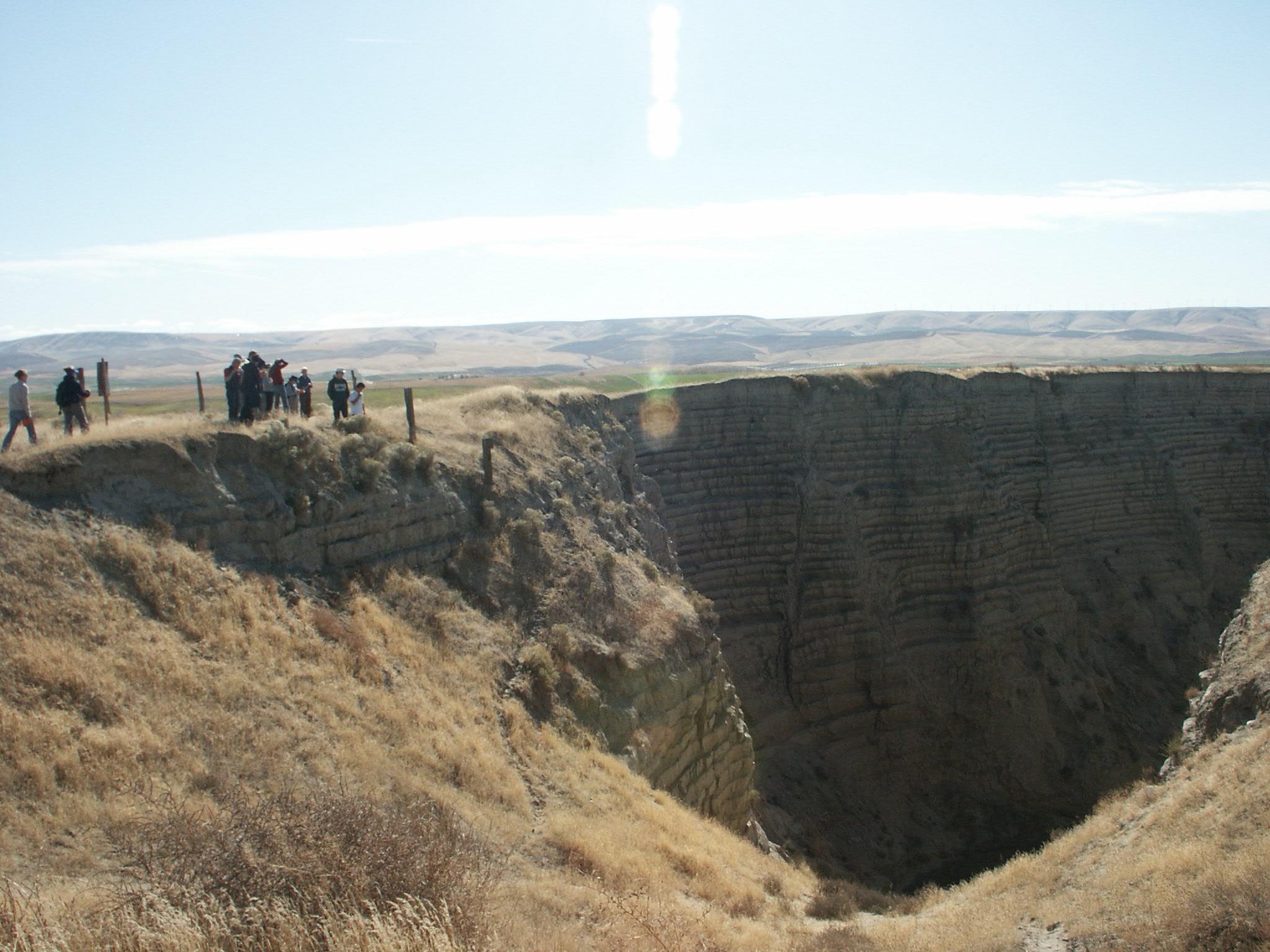
Large boulders, some weighing many thousands of kilograms, known as glacial erratics, are supposed to have been carried by ice for many kilometers before it melted away, dropping the burden of stones and gravel on top of rock strata that is different in composition from the material that was frozen into the icy matrix. Bretz and Pardee did not think that frozen water was responsible for the boulders they found. Instead, they suggested that liquid water rolled and floated the stones downstream, depositing them at the point where the flow diminished enough for them to fall out of suspension.
Erratic boulders are found all over the world. In some cases they lie scattered in fields or stretched out in long lines and are often accompanied by piles of loess (silt and clay supposedly ground up by glaciers and then blown into deep deposits by the wind). Giant sandbars of gravel and glacial till, ripples 30 meters high and 150 meters between crests that march for kilometers across terrain that is desert-like today, and “potholes” 100 meters in diameter and 50 meters deep are also located near them.
It is fortunate that some scientists were (and perhaps are) willing to consider explanations that differ from those that have been established for more than 200 years. It is unfortunate that the proposed alternatives do not take into account electrical activity as a formative agent in structures such as those revealed by the Channeled Scablands.
We have considered the scarring of planets and moons in many previous Picture of the Day articles. Lightning bolts orders of magnitude more powerful than anything seen on Earth today could have created the topography that Bretz and Pardee ascribed to ice dams and flowing water.
As the Electric Universe theory explains, Mars has been subjected to similar electrical jolts that etched its surface with gigantic “skylights” (much like the potholes found in the Scablands), deep canyons with multiple side branches at right angles to the main channel, coulees, dry falls, terraces and other features that can be found on Earth.
Due to their close resemblance to terrestrial physiography, the Martian formations are thought to be extremely old and cut by water millions of years ago. Electricity is never considered part of the equation when geological theories are presented. Bretz, Pardee and NASA scientists have missed a vital clue in the search for answers to the puzzles of planetary scarring.
By Stephen Smith
__________________________________________________________________________Please visit our new "Thunderblog" page
Through the initiative of managing editor Dave Smith, we’ve begun the launch of a new
page called Thunderblog. Timely presentations of fact and opinion, with emphasis on
new discoveries and the explanatory power of the Electric Universe."The Electric Sky and The Electric Universe available now!

|
|

|

EXECUTIVE EDITORS:
David Talbott, Wallace Thornhill
MANAGING EDITORS:
Steve Smith, Mel Acheson
CONTRIBUTING EDITORS: Michael Armstrong, Dwardu Cardona,
Ev Cochrane,
C.J. Ransom, Don Scott, Rens van der Sluijs, Ian Tresman
WEBMASTER: Brian Talbott
Copyright 2008: thunderbolts.info
![]()
home •
thunderblogs •
forum •
picture of the day •
resources •
team •
updates •
contact us