
home •
about •
essential guide •
picture of the day •
thunderblogs •
news •
multimedia •
predictions •
products •
get involved •
contact
picture of the day archive subject index
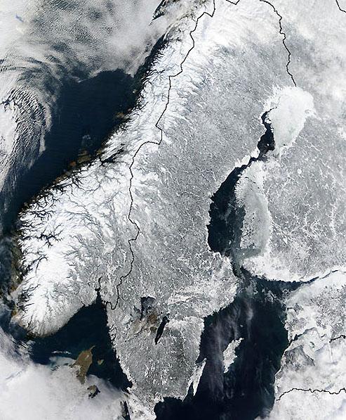
The Scandinavian Peninsula from space.
Credit: NASA GSFC/Jacques Descloitres, MODIS Land Rapid Response Team
Jun 02, 2008
The Norwegian Fjords
What cut the colossal trenches into the coast of Norway? Could it have been glaciers or should electrical forces be considered?Northern Scandinavia is probably the most rugged terrain on Earth. It is a peninsular landmass extending outward from the Asian continent for 2000 kilometers and is notable for the enormous number of deep fjords carved into its northwestern edge. Some of the chasms plunge 800 meters deep with cliff walls 1000 meters high. Many are more than 100 kilometers long – Sognefjorden being the longest at 204 kilometers. In some places, it is more than 1300 meters deep with surrounding mountains of equal height.
Preikestolen (“Pulpit Rock”) overlook provides a spectacular scenic view that is unrivaled, except, perhaps by the Yosemite National Park formations. Preikestolen looks down from 600 meters on deep, clear water, however, rather than a dry landscape. It is similar in structure to the great monolith, El Capitan – a vertical granite wall with little (if any) rock debris below or covering the surrounding terrain. Because most geologists consider the fjords to be glacial in origin, it is theorized that the ice cut the inlets and then “bulldozed” the material ahead of their advance, eventually dumping it into the ocean.
According to conventional understanding, fjords may be shaped by their locations in pre-glacial valleys. The overall nature of the bedrock into which they are carved or fissures and faults in the Earth's crust might also have contributed to their formation since ice flows tend to seek the path of least resistance. Often, the valley floors on either side, near the channels, are flat.
The sea entrances are in shallow water populated by small islands. The deepest portions are usually located far from the mouth of the fjord where, as geologists posit, the glaciers that once filled the valleys carved more deeply into the Earth.
An intriguing aspect to the western coast of Norway is that the fjords, when viewed from space, look like nothing less than innumerable, multiply brachiated Lichtenberg figures. In the image at the top of the page, thousands of fjords are visible as a filigree that divides into finer and finer detail, a signature of lightning-type discharges.
Those discharges must have been unimaginably powerful. They are matched to the east by mountain ranges and inland peaks that reflect the incised forms on the coast, except in reverse: they are embossed upon the landscape. In our Thunderbolts Picture of the Day article about anomalous terrain on Mars, such attributes were identified as “dendritic ridges” – trackways caused by gigantic plasma bolts striking the slopes of Olympus Mons.
Another region that begs further comparison with Scandinavia is the Siberian Traps and the Putorana Plateau in Russia, an area of some 600,000 square kilometers dominated by the same kind of Lichtenberg figures that cut into western Norway. Are they related? Could the same process have created both topographies? One interesting fact that supports the Electric Universe hypothesis is that eastern Greenland reveals thousands of fjords just like those in Norway.
It appears as if tremendous forces gripped the high latitudes of Earth and wrenched pulverized masses of stone out of the surface in powerful, vertical electric fields. Coupled with traveling currents of electricity in the manifold trillion-joule range, the subsurface materials were literally exploded into space or thrown to the winds for thousands of kilometers, resulting in today’s geography.
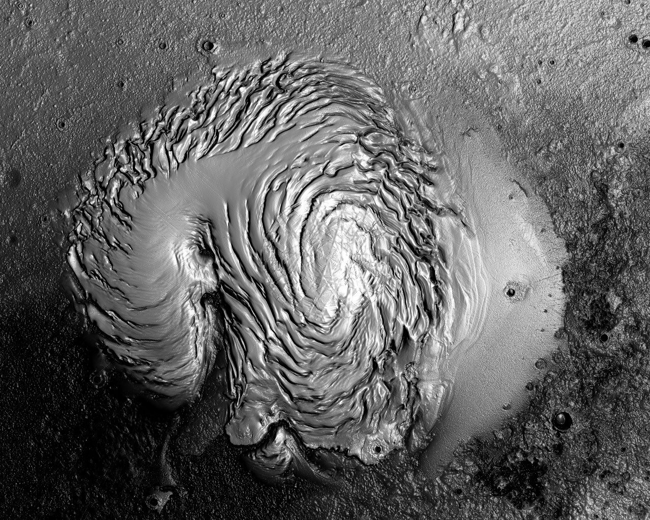
An almost unbelievable piece of evidence remains for our contention that Earth has been visited by catastrophes that reshaped its continents and, perhaps, opened the Atlantic Ocean basin within the memory of human beings on this planet. The Scandinavian Peninsula may be the fossilized vortex of a helical plasma beam that engulfed Siberia, Finland, Norway, Sweden and other locations in a cloud of electric fire powerful enough to change the world.
In a previous Picture of the Day article, polar vortices on Mars were presumed to be the remains of plasma beams that did nearly identical damage to the Red Planet. The northern latitudes were simply wiped away, leaving nothing but a blasted desolation many kilometers below the mean elevation of the planet. A side-by-side comparison of Scandinavia and the North Pole on Mars is revelatory.
By Stephen Smith
___________________________________________________________________________Please visit our Forum
The Electric Sky and The Electric Universe available now!

|
|

|

EXECUTIVE EDITORS:
David Talbott, Wallace Thornhill
MANAGING EDITORS:
Steve Smith, Mel Acheson
CONTRIBUTING EDITORS: Michael Armstrong, Dwardu Cardona,
Ev Cochrane,
C.J. Ransom, Don Scott, Rens van der Sluijs, Ian Tresman
WEBMASTER: Brian Talbott
Copyright 2008: thunderbolts.info
![]()
home •
thunderblogs •
forum •
picture of the day •
resources •
team •
updates •
contact us