
home •
about •
essential guide •
picture of the day •
thunderblogs •
news •
multimedia •
predictions •
products •
get involved •
contact
picture of the day archive subject index
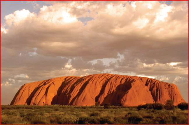
Storm clouds over Uluru. Photographer unknown
Oct 1, 2007
Australia's Big ThreeIn the center of Australia are three of the strangest rock formations found on Earth. Were they formed in a slow, steady process of erosion, or did immense electric currents pull them together?
Once again in our investigation of Earth's anomalous geography, hiding in plain site as it were, we find examples of what might have been concentrated electrical force applied over regions of continental dimension. In Australia's vast empty center are three giant tors that are astonishing for their size. They bear the marks of electric discharge machining and are associated with violent disruption over a wide area. Although Mount Augustus is sometimes considered the largest monolith in the world, it stands alone in its locale and is not closely associated with the big three.
Previous Thunderbolts Picture of the Day articles described structures in Africa and the United States that are very similar to those in Australia. Our conclusion was that they could be the result of highly energetic plasma discharges, so the Australian massifs may also be of electrical origin. The giant stones are also located in close proximity to one another. Their names and locations are:
Uluru - 25° 11' 10" S X 130° 58' 32" E
Mount Conner - 25° 29' 48" S X 131° 53' 56" E
Kata Tjuta - 25° 17' 46" S X 130° 45' 46" E
From before the time of recorded history, the Australian Aboriginal people have considered this part of the country where the big three are located to be sacred. The land is inculcated in their creation stories as the place where gods and planets intersected. Called the Dreamtime, it is the prehistoric period when life and humanity came into being and these formations played a major role. Many places are forbidden to outsiders and there is a growing movement that seeks to bring more of the Aboriginal lands back under their control.
Of the three, Uluru (previously called Ayers Rock) is probably the most familiar. It has been romanticized in literature as well as analyzed in documentaries for many years. Yet, it continues to defy conventional explanation.
Uluru is composed of conglomerated stones and gravel, cemented by a matrix of sandstone. It is 3.6 kilometers long by 2 kilometers wide and rises to 345 meters above the plain. On top, it displays striations with narrow ridges running parallel, along with crater chains and clusters of deep potholes in the "shotgun blast" shape often found in the "inverted terrain" of Patagonia.
The overall shape of Uluru and the fractured topography surrounding it are suggestive of images sent from Mars orbit: scalloped edges, polygonal patterns cut into the rock, dunes, raised mounds, and small craters.
The second structure among the three is Mount Conner, or Attila. It is eighty-eight kilometers east and slightly south of Uluru and can be distinguished in one view by its flat tabletop and horseshoe shape. In other views, the mountain resembles a fist or a great pile of gigantic, rounded sandstone blocks.
Mount Connor is 859 meters above sea level and is 300 meters higher than the surrounding desert. Like its two cousins, the mountain is composed of similar sandstone conglomerate. Nearby are two ridges that extend in sweeping arcs for many kilometers on either side. It also possesses a rich Aboriginal history and cultural heritage.
The last of the big three is Kata Tjuta (also called the Olgas), located 25 kilometers west of Uluru. Kata Tjuta is the largest of the three geologic anomalies, comprising 36 sandstone conglomerate domes. The highest point is Mt. Olga, rising to 546 meters. Like Uluru, it is sacred to the Anangu people and features predominantly in their spiritual rites even to this day.
Covering 22 square kilometers, Kata Tjuta is the largest of the three monoliths. It is composed of the same sandstone matrix surrounding a conglomerate of rocks and gravel. Because these objects are so similar in size, shape and composition, it must be asked what forces could create them? The standard explanation is that they were formed from alluvial deposits laid down over eons of time, gradually forming sedimentary rocks. After hundreds of millions of years, the formations were exposed through erosion after wind and rain removed the overburden grain by grain.
As we have written in past Pictures of the Day, there is the distinct possibility that these formations were created in a relatively short period of time not so long ago. The action of electric arcs moving through rock strata could have gathered all the materials extant in the Australian outback into these creations.
Electromagnetic forces are generated when electricity flows and magnetic fields will ultimately compress the bits and pieces into a solid mass. Rocks, gravel and sand could become solidified blocks of sandstone conglomerate.
By Stephen Smith
___________________________________________________________________________Please visit our Forum
The Electric Sky and The Electric Universe available now!
|
|
|
EXECUTIVE EDITORS:
David Talbott, Wallace Thornhill
MANAGING EDITORS:
Steve Smith, Mel Acheson
CONTRIBUTING EDITORS: Michael Armstrong, Dwardu Cardona,
Ev Cochrane,
C.J. Ransom, Don Scott, Rens van der Sluijs, Ian Tresman
WEBMASTER: Brian Talbott
Copyright 2007: thunderbolts.info
![]()
home •
thunderblogs •
forum •
picture of the day •
resources •
team •
updates •
contact us