
home •
about •
essential guide •
picture of the day •
thunderblogs •
news •
multimedia •
predictions •
products •
get involved •
contact
picture of the day archive subject index
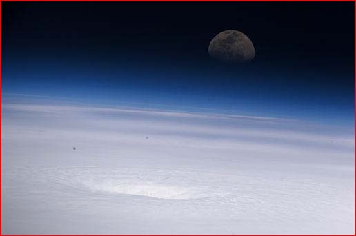
Credit: NASACaption: Expedition 11 NASA Science Officer John Phillips captured this photo of Hurricane
Emily on July 17, 2005, as the storm churned in the Caribbean Sea east of the Yucatan Peninsula.
Apr 20, 2006
The Electric Hurricanes of 2005Another mystery for meteorologists: As a rule, hurricanes display little if any lightning. But during the record-setting hurricane season of 2005 three of the most powerful storms—Rita, Katrina, and Emily—provoked an astonishing abundance of lightning.
Richard Blakeslee of the Global Hydrology and Climate Center (GHCC) in Huntsville, Alabama, was one of a team of scientists who explored Hurricane Emily using NASA's ER-2 aircraft, a research version of the famous U-2 spy plane. Flying high above the storm, they noted frequent lightning in the cylindrical wall of clouds surrounding the hurricane's eye. Both cloud-to-cloud and cloud-to-ground lightning were present, "a few flashes per minute", says Blakeslee. "Generally there's not a lot of lightning in the eye-wall region", Blakeslee says.
In fact, the electric fields above Emily were among the strongest ever measured by the aircraft’s sensors over any storm. "We observed steady fields in excess of 8 kilovolts per meter. That is huge--comparable to the strongest fields we would expect to find over a large land-based 'mesoscale' thunderstorm”.
According to Blakeslee, the reason for the usual absence of lightning in hurricanes is understood. “They’re missing vertical winds” … “A hurricane's winds are mostly horizontal, not vertical. So the vertical churning that leads to lightning doesn't normally happen”.
But why did lightning occur in the recent hurricanes? “We still have a lot to learn about hurricanes”, Blakeslee observes.
Indeed. And we still have a lot to learn about lightning too. The distinguished expert on lightning, Dr. Martin Uman, has admitted that the separation of charges in a thunderstorm remains a mystery. So in truth, the absence of lightning in tornadoes and hurricanes is not understood.
But the answer becomes both simple and undeniable once the electrical nature of the solar system is admitted. An electric solar system could hardly exclude an electric Earth. And once we see electrical phenomena on Earth in relation to the larger circuitry, our planet's atmosphere can be compared to the leaky dielectric in a “self-repairing capacitor”: the charge is already waiting in the ionosphere to be unleashed in storms in the atmosphere. We have seen the electrical connection of thunderstorms to the ionosphere in the appearance of giant lightning bursts to space. These electrical displays have been named “red sprites” and “blue jets”.
From an electrical viewpoint, the vertical winds are not the cause of charge separation because charge separation already exists; the winds are driven by electrical discharge activity. But in a tornado or hurricane the discharge takes on a familiar circular motion, whereupon powerful electromagnetic forces constrain the discharge to what has been called a "charge sheath vortex." Here, the energy of the discharge goes into driving the vortex, imparting to it a devastating power, though visible arcing (lightning) may be minimal.
But it seems that in the most powerful manifestations of the charge sheath vortex, charge separation in the wall of the vortex itself can manifest lightning. And if so, meteorologists would be well advised to expand their investigations of lightning, hurricanes, and tornadoes into the realm of plasma physics.
__________________________________________________________________________Please visit our new "Thunderblog" page
Through the initiative of managing editor Dave Smith, we’ve begun the launch of a new
page called Thunderblog. Timely presentations of fact and opinion, with emphasis on
new discoveries and the explanatory power of the Electric Universe."The Electric Sky and The Electric Universe available now!
|
|
|
EXECUTIVE EDITORS:
David Talbott, Wallace Thornhill
MANAGING EDITOR:
Michael Armstrong
CONTRIBUTING EDITORS: Dwardu Cardona, Ev Cochrane,
C.J. Ransom, Don Scott, Rens van der Sluijs, Ian Tresman
WEBMASTER: Michael Armstrong
Copyright 2006: thunderbolts.info
![]()
home •
thunderblogs •
forum •
picture of the day •
resources •
team •
updates •
contact us