Ion01 wrote:That still does not help my confusion as to how these features were formed on mars as they do appear to be formed by water.
I see what you mean... And yet? Upon closer inspection...
Well, let's do this, I suppose:
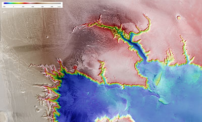
(MOLA elevation map of the "fluid-like" region)
http://www.google.com/mars/#lat=24.0865 ... 367&zoom=5
So far so good, right? But wait, something immediately doesn't look right:
(Western side of that feature)
http://www.google.com/mars/#lat=18.5837 ... 355&zoom=6
(Zooming in closer and switching to visible for better resolution)
http://www.google.com/mars/#lat=22.0347 ... p=infrared
(Again, a bit south)
http://www.google.com/mars/#lat=16.0933 ... ap=visible
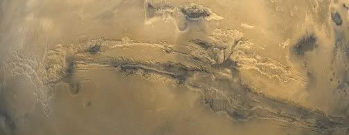
We see the exact same stubby-ending, steep-walled features as Valles Marineris itself. And those features share the exact same "coastline" or border as the section ascribed to "fluids."
Notice that in the latter of the two links above in "IR"/"visible" mode: you also get channels branching at right angles to one another, then abruptly terminating.
Does a fluid do that, flowing along paths of least resistance? I'm doubtful...
The former of the two links above ("infrared") also displays extremely apparent bifurcating / branching patterns.
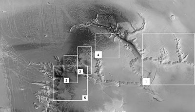
If one moves just a tiny bit south of the latter "visible" mode map above, one finds this region connected to it:
(Straight, shallow "channels" with several parallel branches at right angles in the same direction, all of which terminate.)
http://www.google.com/mars/#lat=14.2856 ... ap=visible
(The long thin channel simply "peters out" here)
http://www.google.com/mars/#lat=11.3373 ... p=infrared
Are we to believe that this long thin channel with branches at right angles was ALSO carved by fluid erosion? I find it highly unlikely.
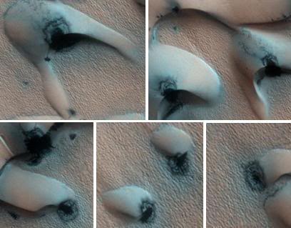
(Crater with a mesa in the middle? Am I reading this wrong? Doesn't seem especially consistent with an "impact," but does appear consistent with the description sometimes given by Thornhill
et al of twined arcs machining a surface, and leaving the middle all or mostly untouched...)
http://www.google.com/mars/#lat=14.5702 ... p=infrared
(Notice that what appears fluid-like also terminates quite abruptly along extremely well defined lines. Is that to be expected of fluids flowing to/from someplace like this?)
http://www.google.com/mars/#lat=16.0854 ... p=infrared
Is it consistent with fluids, or perhaps with something closer to a corona discharge or sheet discharge? A la intimations about Europa. Not saying that's necessarily "the" answer, but an interesting question.
http://www.thunderbolts.info/tpod/2005/ ... europa.htm
(One is also tempted to point out the "island" displays characteristics of arc discharges as well. Note the several discontinuous "channels" incised into the "island." Note that several of them on opposite sides are aligned in parallel, and actually if you draw a line between their end points they connect along pretty much straight lines.)
http://www.google.com/mars/#lat=24.6470 ... 974&zoom=7
One is tempted to point out the question of which direction the water would be purported to flow in? From the SW to the NE, or vice versa? One would ASSUME it would flow down hill...? IE, SW to NE. But, then how does the "bifurcating" / "branching" configuration mentioned earlier form if it was created solely through fluid erosion? And why would it start in the particular areas it does? it seems to be in the middle of the much larger feature, and might have been at the bottom of a river or some such. One wouldn't expect that feature to show up right there?
Fluids seem to just create more questions than answers, when taking the specific features into mind.
(For instance this stubby "finger" [or whatever you want to call it] that actually looks a bit more like a crater chain...)
http://www.google.com/mars/#lat=20.2209 ... p=infrared
(One is also tempted to point out the extremely "scalloped" nature of all the steep walls in the region. A feature which I believe Wal has repeatedly pointed out to be typical of electrical sculpting of such features.)
http://www.google.com/mars/#lat=16.5730 ... p=infrared
Speaking of which, would a river or sea be expected to create such steep walls to begin with? Or would it have generally a much more subtle "shoreline?"
Just a few points to ponder...
~Michael Gmirkin


