166470
See my previous discussion of Cardona's Arctic errors etc at:
https://www.thunderbolts.info/wp/forum3/ph ... =645#p6822
ALMOST NO EROSION BETWEEN MEGASEQUENCES
Last year it occurred to me that the megasequences of sedimentary strata must have been deposited in a short period of time if there is little or no channeled erosion evident between them. I haven't given that enough thought though. If the Great Flood deposited the bottom 4 or 5 megasequences (Zuni being number 5) and if it occurred several centuries before the Younger Dryas event, and if the Younger Dryas event included a major flood that deposited the final megasequence/s (Tejas being number 6 and last), there should have been a lot of erosion of channels or ditches in the Zuni. See the following maps.
SEDIMENTARY ROCK STRATA MEGASEQUENCES MAPS OF THE AMERICAS & AFRICA
https://ibb.co/ZcmCxPH
In the top row of maps there of North America, the first two show no megasequences in the Gulf of Mexico. That seems to be because the Gulf had not yet formed because Pangaea was not yet hit by the asteroid that broke it up and opened up the Gulf and the Atlantic Ocean and some of the Indian Ocean.
Since the Zuni and Tejas strata are both in the Gulf, the Gulf must have opened up at that point, so the asteroid must have hit Pangaea just before that. The next two rows of maps of South America and Africa show a similar pattern. It's mostly only Zuni and Tejas sediments that flowed into the Gulf of Mexico and the Atlantic Ocean from South America and into the Mediterranean Sea and the Atlantic and Indian Oceans from Africa.
Another problem is that it looks like the Zuni and Tejas sediments also underlie the area of the Great Pyramid along the Nile in Egypt. It looks like maybe a kilometer or more of those sediments. That would mean that the Great Pyramid would have been built on top of all that afterwards.
So it seems that Mike Fischer must have been wrong about the Pangaea breakup having occurred centuries after the Great Flood. Maybe there was only one Great Flood at the time of the Younger Dryas. But I had previously concluded that Tiahuanaco was likely built soon after the Great Flood before Pangaea broke up and caused Tiahuanaco to be raised up from sea level to its present height of 12 thousand feet.
The situation is too complex for my limited logic faculties. Maybe a little meditating will help.
Creationism, Myth and Catastrophism
-
Lloyd
- Posts: 5448
- Joined: Fri Apr 04, 2008 9:54 pm
Re: Creationism, Myth and Catastrophism
166916
RETHINKING OUT LOUD
Earth History is a huge puzzle. By rearranging the puzzle pieces I hope to find which ones fit together. Sometimes two or more pieces are so similar that they seem to fit when they really don't. The situation sometimes gets mind-boggling, but then I start working on a different part of the puzzle for a while, & sometimes the boggling decreases. Si?
GREAT FLOOD DEPOSITED MEGASEQUENCES
_Mseq means megasequence (of sedimentary rock strata).
_1. There are 6 or 7 Mseq's (from bottom to top): PreSauk(?), Sauk, Tippe., Kas., Absar., Zuni, Tejas
_Are there erosion channels (ditches) evident in the top surface of any mseq?
__PROBABLY NOT (as I said in my previous post)
_2. If not, then all of the mseq's were likely deposited in close succession during the Great Flood.
_3. Since Zuni & Tejas are about the only mseq's in
the Gulf of Mexico, the Mediterranean Sea & the edges of the Atlantic & Indian Oceans,
and since those bodies of water likely formed as Pangaea broke up from a major impact,
it's likely that Pangaea broke up before those last two mseq's were deposited
(contrary to what I've been thinking for the past year nearly).
GREAT BASINS
_4. Asteroid impacts formed many Great Basins on Pangaea before it broke up. Many of them contain all of the mseq's.
GREAT ICE SHEET
_5. The Great Ice Sheet likely formed shortly after the Great Flood from water vapor that came from Flood waters entering & contacting the newly formed ocean basins of thick molten magma.
_6. Widespread volcanic dust & asteroid impact dust (& possibly Saturn nova nitrogen gases) likely cooled the atmosphere, which produced heavy snowfall from the water vapor, which formed the Great Ice Sheet.
FOUR GRAND CANYONS
_7. 4 Grand Canyons formed on Earth, in Tibet, Arizona, Antarctica & Greenland.
TSANGPO GORGE OF TIBET
_This canyon is along the northern edge of the Himalaya Mountains.
It's a bit longer & deeper than the Grand Canyon.
It appears to have formed as Pangaea broke up.
The asteroid impact split India from Africa & shoved India across the Indian Ocean,
where the leading edge of India wedged under Asia at Tibet, China, raising up the Himalayas.
Some Indian Ocean waters were pushed ahead of India & the rising mountains,
which then drained eastward and south back into the Indian Ocean near Bangladesh, thus forming the canyon.
Here's a map of the canyon: https://en.wikipedia.org/wiki/Yarlung_T ... basins.jpg
GRAND CANYON OF ARIZONA
_This canyon must have formed by water erosion just after the Colorado Plateau uplifted
due to the North American tectonic plate overriding the East Pacific Rise (an Ocean Ridge).
So that was also after the asteroid impact that broke up Pangaea, pushing away North America.
The canyon erosion occurred either as Great Flood waters were receding from the continent,
or maybe some months or years after the Flood when two large lakes breached natural dams.
If the North American ice sheet extended to the Colorado Plateau, then it's possible that the YD event was involved.
If the YD or Younger Dryas event occurred just a few decades after the Great Flood & after the ice sheet formed,
it may have melted the glaciers & breached the natural dam of Grand & Hopi Lakes.
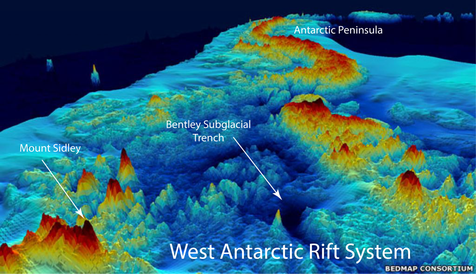
CANYONS OF ANTARCTICA ARE RIFTS
_This traces the canyon system on a map.
https://www.scientificamerican.com/arti ... ntarctica/
An article says as follows at https://source.wustl.edu/2015/12/the-ge ... underside/
"Much of West Antarctica is a basin.... West Antarctica was stretched and thinned as it moved away from East Antarctica, forming one of the world’s largest continental rift systems.
Map of West Antarctic Rift System
https://source.wustl.edu/wp-content/upl ... cture1.png
As rifts, they likely didn't involve significant water erosion.
GREENLAND CANYON MAY BE A RIFT
_There's a video of the Greenland canyon here.
https://upload.wikimedia.org/wikipedia/ ... p.vp9.webm
Here's an image from the video: https://ibb.co/yVk8t7r
We can call the letters at the bottom longitude and the numbers on the right latitude.
At Long. H/I, Lat. 8 the canyon appears to be interrupted by a couple great dams of rock.
At Long. J, Lat. 5 it looks like a couple more dams. And others may occur as well.
I think this is similar to Africa's Rift Valley, so I think the Greenland canyon may be more likely a rift than a canyon.
Canyons are formed by water erosion, but rifts are formed by land being pulled apart, I think.
So my guess is that this canyon/rift formed without water erosion as Pangaea broke apart.
YOUNGER DRYAS EVENT
_8. This event involved asteroids &/or comets that impacted the Great Ice Sheet & other places
_9. The impacts melted most of the Great Ice Sheet, causing Floods.
_10. Impacts on the Great Ice Sheet also caused secondary impacts of ice boulders that killed most animals & people in North America.
_11. There was a Conflagration over much of the world, caused by impacts &/or a Saturn nova.
_12. The many animals of Siberia were killed by impacts, loess, loss of oxygen (atmosphere), floods, super-hurricane winds & super-cold air or gases from the upper atmosphere &/or from a Saturn nova.
_13. One or more impact-formed basins in Siberia filled with flash-frozen ice & debris (from rocks, dust, loess, & mutilated & smashed plants & animals).
_14. Gordon once said that the sediments in the Washington Scablands were interbedded, lava & limestone, or something, which means they all likely formed at the same time. He said there were large lenses of diatomaceous earth, which came from ocean tsunamis.
_15. The Missoula Flood, which likely involved flooding from Canada, carved out the Scablands.
_16. There's a lot of Magma Basalt in Washington too. Likewise in India, Siberia etc.
HUMAN INVOLVEMENT
_17. Some myths & legends say that humans witnessed mountains forming.
_18. Tiahuanaco is a mystery again. Lake Titicaca nearby was raised up from sea level to its present altitude of 12,000 feet. A harbor on the lake is said to be big enough to hold a hundred ships. It's the largest lake in South America now, a few hundred miles long, but it used to be much bigger. Were there enough cities in the Andes to handle a hundred ships for trade?
_19. Giza in Egypt is situated on the last mseq's, so it must have been built after the Great Flood. Another Flood covered the Great Pyramid about half way up, I guess 200 feet deep or so, long enough to produce salt incrustation. I guess that was from the Younger Dryas flooding.
RETHINKING OUT LOUD
Earth History is a huge puzzle. By rearranging the puzzle pieces I hope to find which ones fit together. Sometimes two or more pieces are so similar that they seem to fit when they really don't. The situation sometimes gets mind-boggling, but then I start working on a different part of the puzzle for a while, & sometimes the boggling decreases. Si?
GREAT FLOOD DEPOSITED MEGASEQUENCES
_Mseq means megasequence (of sedimentary rock strata).
_1. There are 6 or 7 Mseq's (from bottom to top): PreSauk(?), Sauk, Tippe., Kas., Absar., Zuni, Tejas
_Are there erosion channels (ditches) evident in the top surface of any mseq?
__PROBABLY NOT (as I said in my previous post)
_2. If not, then all of the mseq's were likely deposited in close succession during the Great Flood.
_3. Since Zuni & Tejas are about the only mseq's in
the Gulf of Mexico, the Mediterranean Sea & the edges of the Atlantic & Indian Oceans,
and since those bodies of water likely formed as Pangaea broke up from a major impact,
it's likely that Pangaea broke up before those last two mseq's were deposited
(contrary to what I've been thinking for the past year nearly).
GREAT BASINS
_4. Asteroid impacts formed many Great Basins on Pangaea before it broke up. Many of them contain all of the mseq's.
GREAT ICE SHEET
_5. The Great Ice Sheet likely formed shortly after the Great Flood from water vapor that came from Flood waters entering & contacting the newly formed ocean basins of thick molten magma.
_6. Widespread volcanic dust & asteroid impact dust (& possibly Saturn nova nitrogen gases) likely cooled the atmosphere, which produced heavy snowfall from the water vapor, which formed the Great Ice Sheet.
FOUR GRAND CANYONS
_7. 4 Grand Canyons formed on Earth, in Tibet, Arizona, Antarctica & Greenland.
TSANGPO GORGE OF TIBET
_This canyon is along the northern edge of the Himalaya Mountains.
It's a bit longer & deeper than the Grand Canyon.
It appears to have formed as Pangaea broke up.
The asteroid impact split India from Africa & shoved India across the Indian Ocean,
where the leading edge of India wedged under Asia at Tibet, China, raising up the Himalayas.
Some Indian Ocean waters were pushed ahead of India & the rising mountains,
which then drained eastward and south back into the Indian Ocean near Bangladesh, thus forming the canyon.
Here's a map of the canyon: https://en.wikipedia.org/wiki/Yarlung_T ... basins.jpg
GRAND CANYON OF ARIZONA
_This canyon must have formed by water erosion just after the Colorado Plateau uplifted
due to the North American tectonic plate overriding the East Pacific Rise (an Ocean Ridge).
So that was also after the asteroid impact that broke up Pangaea, pushing away North America.
The canyon erosion occurred either as Great Flood waters were receding from the continent,
or maybe some months or years after the Flood when two large lakes breached natural dams.
If the North American ice sheet extended to the Colorado Plateau, then it's possible that the YD event was involved.
If the YD or Younger Dryas event occurred just a few decades after the Great Flood & after the ice sheet formed,
it may have melted the glaciers & breached the natural dam of Grand & Hopi Lakes.
CANYONS OF ANTARCTICA ARE RIFTS
_This traces the canyon system on a map.
https://www.scientificamerican.com/arti ... ntarctica/
An article says as follows at https://source.wustl.edu/2015/12/the-ge ... underside/
"Much of West Antarctica is a basin.... West Antarctica was stretched and thinned as it moved away from East Antarctica, forming one of the world’s largest continental rift systems.
Map of West Antarctic Rift System
https://source.wustl.edu/wp-content/upl ... cture1.png
As rifts, they likely didn't involve significant water erosion.
GREENLAND CANYON MAY BE A RIFT
_There's a video of the Greenland canyon here.
https://upload.wikimedia.org/wikipedia/ ... p.vp9.webm
Here's an image from the video: https://ibb.co/yVk8t7r
We can call the letters at the bottom longitude and the numbers on the right latitude.
At Long. H/I, Lat. 8 the canyon appears to be interrupted by a couple great dams of rock.
At Long. J, Lat. 5 it looks like a couple more dams. And others may occur as well.
I think this is similar to Africa's Rift Valley, so I think the Greenland canyon may be more likely a rift than a canyon.
Canyons are formed by water erosion, but rifts are formed by land being pulled apart, I think.
So my guess is that this canyon/rift formed without water erosion as Pangaea broke apart.
YOUNGER DRYAS EVENT
_8. This event involved asteroids &/or comets that impacted the Great Ice Sheet & other places
_9. The impacts melted most of the Great Ice Sheet, causing Floods.
_10. Impacts on the Great Ice Sheet also caused secondary impacts of ice boulders that killed most animals & people in North America.
_11. There was a Conflagration over much of the world, caused by impacts &/or a Saturn nova.
_12. The many animals of Siberia were killed by impacts, loess, loss of oxygen (atmosphere), floods, super-hurricane winds & super-cold air or gases from the upper atmosphere &/or from a Saturn nova.
_13. One or more impact-formed basins in Siberia filled with flash-frozen ice & debris (from rocks, dust, loess, & mutilated & smashed plants & animals).
_14. Gordon once said that the sediments in the Washington Scablands were interbedded, lava & limestone, or something, which means they all likely formed at the same time. He said there were large lenses of diatomaceous earth, which came from ocean tsunamis.
_15. The Missoula Flood, which likely involved flooding from Canada, carved out the Scablands.
_16. There's a lot of Magma Basalt in Washington too. Likewise in India, Siberia etc.
HUMAN INVOLVEMENT
_17. Some myths & legends say that humans witnessed mountains forming.
_18. Tiahuanaco is a mystery again. Lake Titicaca nearby was raised up from sea level to its present altitude of 12,000 feet. A harbor on the lake is said to be big enough to hold a hundred ships. It's the largest lake in South America now, a few hundred miles long, but it used to be much bigger. Were there enough cities in the Andes to handle a hundred ships for trade?
_19. Giza in Egypt is situated on the last mseq's, so it must have been built after the Great Flood. Another Flood covered the Great Pyramid about half way up, I guess 200 feet deep or so, long enough to produce salt incrustation. I guess that was from the Younger Dryas flooding.
-
Lloyd
- Posts: 5448
- Joined: Fri Apr 04, 2008 9:54 pm
Re: Creationism, Myth and Catastrophism
168706
WHICH STRATA BELONG TO WHICH MEGASEQUENCE
Can ‘megasequences’ help define biblical geologic history?
https://creation.com/images/pdfs/tj/j29 ... _16-25.pdf
_The 6 mseq's are: 1) Sauk, 2) Tippecanoe, 3) Kaskaskia, 4) Absaroka, 5) Zuni, and 6) Tejas.
_According to this article, the following conventionally named strata occurred approximately within each mseq.
1) Sauk: +Cambrian+
2) Tippecanoe: -Ordovician +Silurian+
3) Kaskaskia: -Devonian +Mississippian
4) Absaroka: Pennsylvanian +Permian +Triassic+
5) Zuni: -Jurassic +Cretaceous+
6) Tejas: -Tertiary+
CREATIONIST ARTICLE HAS POSSIBLE EVIDENCE THAT PANGAEA BROKE UP CENTURIES AFTER THE GREAT FLOOD
Mike Fischer says that, so I'm posting most of the latter part of the article here. Subtitles in brackets are mine.
Use of Sedimentary Megasequences to Re-create Pre-Flood Geography (2018)
https://digitalcommons.cedarville.edu/c ... roceedings
...
__Upland Areas
[MSEQ's ARE THICKEST NEAR EDGES OF CONTINENTS]
_Our study found that all megasequences thinned toward the crystalline shield areas on all three continents.
_The sedimentary units do not merely show evidence of erosion and truncation, but become thinner in the direction of the shields,
implying they were deposited on the flanks of extensive uplands.
[See Figure 10.]
_Figure 14 shows four stratigraphic profiles across the northern USA.
_All show dramatic thinning of the megasequences from south to north toward the shield, in support of this interpretation.
[ZUNI MSEQ WAS THE HIGH WATER MARK OF THE FLOOD]
_The top of the Zuni megasequence (fifth megasequence) seems to represent the highest water level of the Flood
as water washed over the top of the pre-Flood high hills and uplands, giving the most globally extensive deposition of any megasequence (Figs. 11, 12, 13).
_Recall, the Zuni megasequence also has the maximum volume of sediment deposited globally (Fig. 7).
_This deposit likely represents the Day 150 high water point of the Flood.
_Many of these interpreted upland areas are completely devoid of any sedimentary rock
as post-Flood erosion has stripped the little amount of possible Zuni sediment that may have been deposited.
_According to Genesis 7:20, the highest hills were only flooded by a modest amount of water,
likely leaving little room for thick sedimentary deposits as the Flood waters receded.
_However, there are a few Zuni remnants in Hudson Bay and Michigan and Illinois in North America
that indicate the highest water level was achieved at this point in the Flood (Fig. 11).
_Humphreys (2014, p. 57) in his translation of Genesis 6:7 and Genesis 7:23 suggests the term ‘wiped off”
to explain this stripping of the land surface right down to the crust: ....
_“Thus He wiped off every living thing that was upon the face of the land, from man to animals to creeping things and to birds of the sky,
and they were wiped off from the earth…” (emphasis in original). ...
_“Taking these verses straightforwardly means the waters swept mud, plants, the animals completely off the formerly dry land,
the pre-Flood continental surface” (Humphreys 2014, p. 57).
_And this is exactly what we see across large portions of the continents.
_The pre-Flood uplands include the major shield areas of Canada, Greenland, Brazil and Central and Western Africa.
_When placed back together in a Pangaea-like configuration, the upland areas match up across continents and become quite substantial (Fig 8).
[TEJAS IS ERODED DEPOSITS FROM ZUNI; COAL, MAMMALS, HUMANS]
_The Tejas megasequence rocks likely represent material washed off the highest upland areas of the pre-Flood world
and ‘backwashed’ onto the Zuni as the Flood waters began to recede (Day 150+) (Figs. 15, 16, 17).
_Fossils in the Tejas megasequence also contain increasingly more angiosperms and mammal fossils compared to the Zuni deposits,
indicative of more upland terrains.
_These areas were apparently wiped free of all life, removing even the pre-Flood soil and any rock layers that might have existed there.
_Deposits in the Tejas include the thickest and most extensive coal seams in the world (Clarey 2017a).
[See Figure 13.]
_These huge mats of transported trees, almost exclusively non-lycopods, likely represented plants swept off the uplands.
_[] the Flood, apparently ‘wiped off’ these areas of highest elevation, where most of the large mammals, flowering plants and possibly humans may have existed,
spreading their remains in sedimentary layers on top of the earlier buried dinosaurs in rocks now identified as Cenozoic strata.
[TEJAS DEPOSITIONAL DIFFERENCES]
_Animals were likely buried closer to their place of origin as the Flood waters were rising
(from the Sauk through the Zuni megasequences) until Day 150 was reached.
_The water and sediment engulf[ed] them nearly in situ as the water level increased.
_Advancing and rising Flood water probably buried marine animals in shallow seas in the first three megasequences
and the dinosaurs and other and wetland animals were later buried near their lowland locations (with some obvious transport).
_Hence, [this is] a possible reason for the ‘straddling’ of the dinosaur quarries across this so-called ‘peninsula’ of lowlands
that extended through the central USA (Clarey 2015).
_But the Tejas depositional pattern appears to have been different.
_It was ... apparently [the] result of a reversal in flow direction as [x] began to remove the waters from off the continents (post-Day 150).
_This not only transported the flora and fauna from off of the highest hills (uplands),
it spread those deposits more radially toward the continental margins.
_Animals and plants that lived in areas that are now exposed crystalline rock (the Precambrian shields),
were transported great distances and deposited on top of the Zuni strata and sometimes older exposed strata too.
[FLOOD WATER FLOW NORTHWARD]
_Is there any evidence of a reversal of water flow direction at the Zuni/Tejas boundary as suggested by this hypothesis? The answer is yes.
[See Figures 14, 15, 16, 17.]
_Although Chadwick’s (2001) current direction data is less conclusive across the Zuni/Tejas (K-Pg) boundary (Clarey 2017b),
research by Blum and Pecha (2014) using detrital zircons did show a dramatic shift in the direction of drainage from the Cretaceous
(uppermost Zuni) to the Paleocene (lowermost Tejas) across North America.
_These authors found that during deposition of the Cretaceous (Zuni Sequence),
the drainage pattern was dominantly to the north and northwest across much of the USA.
_Drainage was to the Boreal Sea near present-day Alberta and Saskatchewan.
_They also determined that very little area was draining to the Gulf of Mexico (GOM) during this time.
[TEJAS WATER FLOW SOUTHWARD]
_In contrast, they determined that the Paleocene drainage shifted dramatically from that of the Cretaceous,
resulting in much of the USA draining southward to the GOM (Blum and Pecha 2014).
_As noted on their map, this was not a single river like the modern Mississippi River, but a series of rivers,
effectively behaving more like sheet wash, draining into the GOM all at once.
[COMMENT: Cardona stated in Thoth that some Native Americans said the Flood came from the north. The Tejas southward flood flow sounds like Younger Dryas flooding, instead of the Great Flood. So maybe Mike is right, that the Tejas came some centuries later.]
_This shift in drainage coincides nicely with the end of the Zuni megaequence and the onset of the Tejas megaequence.
_Blum and Pecha (2014) believe this change in drainage occurred
because of the high flooding levels of the North American continent during the Upper Cretaceous, known as the Cretaceous Interior Seaway.
_They claim that the withdrawal of the flood waters during the uppermost Cretaceous and earliest Paleocene
caused significant reorganization in the drainage pattern and a reverse in flow toward the GOM.
_Clarey and Parkes (2016) used this documented shift in drainage at the Zuni/Tejas boundary
to explain the Whopper Sand in the deep-water of the Gulf of Mexico (Fig. 18).
_Since 2001, with the drilling of the BAHA-2 oil well,
billions of barrels of oil have been discovered in the Paleocene-Eocene Wilcox-equivalent “Whopper Sand” (Higgs 2009).
_This well reportedly encountered 335 m (1100 feet) of sand in the Lower Wilcox
in over 2135 m (7000 feet) of water within the Perdido Fold Belt of Alaminos Canyon.
_In Keathley Canyon the Sardinia-1 well encountered over 366 m (1200 feet) of sand and in Walker Ridge,
the Jack-2 well and Chinook and Cascade-2 wells reached similarly thick Lower Wilcox sands approaching 580 m (1900 feet) thick (Trammel 2006).
_Average porosity in the whopper sand is 18% and permeabilities range from 10-30 md (Trammel 2006).
_Up to 15 billion barrels have been discovered in this trend since 2001.
_What makes the Whopper Sand unusual is its location in deep water, nearly 300 km from the Lower Wilcox shelf margin,
and far from any conventional sand source (Higgs 2009).
[See Figure 18.]
_Clarey and Parkes (2016) believe the Whopper Sand may be a consequence of this rapid drainage shift at the Zuni/Tejas boundary,
when water suddenly began to drain off the North American continent (Interior Seaway)
into the GOM, permanently reversing the earlier direction of flow.
_This shift is marked by the sudden change in deposition from the uppermost Zuni layer (the Lower Paleocene Midway Shale)
to the lowermost Tejas (PaleoceneEocene Whopper Sand).
_In a Flood model, this would coincide with the change in water direction described for Day 150+ of the Flood.
[TEJAS SEA LEVEL DROP]
_Initial drainage rates in the Paleocene, coinciding with a sudden drop in sea level at the onset of the Tejas,
were likely high volume and highly energetic, providing a possible mechanism to transport the thick Whopper Sand into deep-water.
_Over time, the drainage volume lessened, lowering the energy available for transport, until the present-day pattern developed.
_We now observe small flows compared to what was likely happening during the initial draining of the vast North American platform at the start of the Tejas.
[LACK OF HUMAN FOSSILS]
_This hypothesis may also help explain the lack of human fossils in the rock record.
_Most pre-Flood humans likely survived until close to Day 150 and were probably clinging to the areas of highest ground.
_As the water levels crested on Day 150, humans were ‘wiped off,’ spreading their dead bodies in all directions from a zone of concentration,
radially transporting them great distances.
_This process would have spread their remains and lessened the likelihood of finding a concentration of human fossils.
_And, if they were not buried deep enough in sediment, they would not be preserved as fossils either.
_Erosion after the Flood would affect the highest strata the most and any humans buried in the uppermost few meters as a consequence.
[MASSIVE TEJAS IN SOUTH AMERICA & MOUNTAIN RANGES UPLIFT]
_As mentioned earlier, South America has a greater volume of Tejas than Zuni (Fig. 7).
_Why so much Tejas in South America?
_A lot is probably due to the contribution of Central America which formed mostly in the Cenozoic (Tejas).
_And it appears the tectonics of both North and South America played a major role in the volume deposited during the Tejas.
_The higher volume of Tejas sediment on both continents is partly caused
by the uplift of Tejas-age (Cenozoic) mountain ranges (the Rocky Mountains and Andes Mountains) that run the length of the respective continents.
_These major mountain ranges shed tremendous amounts of sediment during their uplift,
creating great volumes of Tejas sedimentary rock east of the mountain ranges.
_And combining that with the increased amount of sediment caused by the formation of Central America,
and we get a greater volume of Tejas deposition for South America.
_Africa, in contrast, has no significant, Tejas-age (Cenozoic) mountain ranges
running the length of the continent to provide additional volumes of Tejas sediment.
[TEJAS GAPS IN MOUNTAIN RANGES]
_Finally, note that the Tejas isopach maps of North America and South America show cut-out areas
where no Tejas exists in the regions of the Rocky Mountains and the Andes Mountains (Figs. 15, 17).
_Erosion has exposed the underlying ... basement rocks in these location[s] due to Cenozoic uplift.
_This in effect, separated the various sedimentary basins, particularly in North America.
_The coarseness of the stratigraphic column spacing prevented us from showing every isolated basin and further details,
and as a result, we acknowledge that there are likely some minor errors in the map due to averaging between the columns.
_However, we feel the cut-out areas on the maps adequately portray the basement exposures and the areas where no Tejas exists.
_Any averaging errors are extremely minor compared to the continental scale of the maps and the overall totals for the stratigraphic data.
[COMMENT: I copied most of the maps from the article at https://ibb.co/ZcmCxPH . There you can compare the Zuni to the Tejas deposition etc. I hope to do some analysis on the maps and maybe Mike will help.]
-
Lloyd
- Posts: 5448
- Joined: Fri Apr 04, 2008 9:54 pm
Re: Creationism, Myth and Catastrophism
169120
QUESTIONS FOR MIKE & OTHERS
MEGASEQUENCE MAPS
Go to the paper, Use of Sedimentary Megasequences to Re-create Pre-Flood Geography, at this link 5 times in 5 tabs.
https://digitalcommons.cedarville.edu/c ... roceedings
NORTH AMERICA
1. On the first tab (of your computer) scroll to page 354 to show the first two mseq's (Sauk & Tippecanoe).
2. On the second tab scroll to page 354 also, but to show the third mseq (Kaskaskia).
3. On the third tab scroll to page 363 to show the next two mseq's (Absaroka & Zuni).
4. On the fourth tab scroll to page 366 to show the last mseq (Tejas).
Zoom in or out on each tab to fill the screen with the map.
Green, yellow & red colors indicate over 7 km deep sedimentary strata.
Light blue indicates 3-6 km deep sedimentary strata.
Dark blue indicates under 3 km deep sedimentary strata.
WHEN IMPACT BASINS FORMED
1. Open the first tab and notice that the Sauk entered 3 deep impact basins at N. Canada, Nova Scotia & N. Carolina, and shallower ones in Nevada, Alberta etc.
The Tippecanoe strata entered a very deep impact basin in W. Alaska & a deep one in N. Greenland.
2. At the second tab the Kaskaskia strata entered one deep impact basin off E. Greenland plus other shallower ones around the continent.
3. At the third tab the Absaroka strata entered a deep impact basin in Arkansas & one in Oregon etc.
The Zuni strata then entered a deep impact basin in SW Alaska, W. Greenland, east & west of Florida & other places.
4. At the fourth tab the Tejas strata entered deep impact basins at the Aleutian Islands of Alaska, W. Washington & W. Oregon, and the western Gulf of Mexico etc.
WHEN THE ATLANTIC FORMED
1,2. There's little or no indication that strata formed off of the N. American continent in the Atlantic Ocean or the Gulf of Mexico during the first 3 mseq's
(Sauk, Tippecanoe, Kaskaskia).
3. The Absaroka strata did not enter any of the Gulf of Mexico. They did settle off the East coast from Virginia to Newfoundland, but maybe not beyond the continental shelf.
**The Zuni strata did enter the Gulf of Mexico & it also settled on the eastern continental shelf or maybe into the Atlantic.
4. The Tejas strata also entered the Gulf of Mexico & also settled on the shelf etc.
__QUESTION #1. Since the Zuni strata entered the Gulf, doesn't that mean the Gulf formed at that time from the Shock Dynamics impact?
AFRICA
1. Reset the first tab scrolling to page 355 to show the first two mseq's (Sauk & Tippecanoe).
2. On the second tab scroll to page 355 also, but to show the third mseq (Kaskaskia).
3. On the third tab scroll to the bottom of page 363 to show the next two mseq's (Absaroka & Zuni).
4. On the fourth tab scroll to page 367 to show the last mseq (Tejas).
Zoom in or out on each tab to fill the screen with the map.
WHEN IMPACT BASINS FORMED
1,2. No impact basins over 4 km deep formed before the first 3 mseq's.
3. 2 or 3 deep impact basins were entered by the Absaroka mseq around SE Africa.
The Zuni strata entered 3 deep impact basins along the west coast of Africa, one around Lake Chad and one at the north coast of Algeria.
4. The Tejas strata entered a deep impact basin on the coast of Cameroon and another on the north coast of Egypt.
WHEN THE ATLANTIC & INDIAN OCEANS FORMED
1,2. No strata of the first 3 mseq's entered the ocean basins.
3. **Some Absaroka strata entered the Indian Ocean by E. Africa & maybe some entered the Atlantic by the NW coast.
**Some Zuni strata entered the eastern Mediterranean, a sliver of the Red Sea, the Indian Ocean off the SE coast & the Atlantic along the entire west coast.
4. The Tejas strata entered much of the Mediterranean, the Red Sea, & both oceans.
__QUESTION #2. **In order for the Absaroka and Zuni strata to enter the Indian & Atlantic Oceans & the Mediterranean & Red Seas, wouldn't the Shock Dynamics impact have had to occur at that time?
HIGHLIGHTS OF PREVIOUS POST
In my last forum post at https://www.thunderbolts.info/wp/forum3/ph ... 6859#p6859 I copied the last part of the Megasequences paper discussed above. Here are some highlights from that post.
CHANGE IN FLOOD WATER FLOW DIRECTIONS
_Is there any evidence of a reversal of water flow direction at the Zuni/Tejas boundary as suggested by this hypothesis? The answer is yes.
_These authors found that during deposition of the Cretaceous (Zuni Sequence),
the drainage pattern was dominantly to the north and northwest across much of the USA.
_Drainage was to the Boreal Sea near present-day Alberta and Saskatchewan.
_They also determined that very little area was draining to the Gulf of Mexico (GOM) during this time.
_In contrast, they determined that the Paleocene drainage shifted dramatically from that of the Cretaceous,
resulting in much of the USA draining southward to the GOM [Gulf of Mexico]....
__QUESTION #3. Is it likely that the different directions of water flow indicate two different Floods, the northward flow of the Great Flood and the southern flow of the Younger Dryas Flood?
TEJAS STRATA
_The Tejas megasequence rocks likely represent material washed off the highest upland areas of the pre-Flood world
and ‘backwashed’ onto the Zuni as the Flood waters began to recede
_Fossils in the Tejas megasequence also contain increasingly more angiosperms and mammal fossils compared to the Zuni deposits,
indicative of more upland terrains.
_These areas were apparently wiped free of all life, removing even the pre-Flood soil and any [sedimentary?] rock layers that might have existed there.
_The higher volume of Tejas sediment on both continents [N. & S. America] is partly caused
by the uplift of Tejas-age (Cenozoic) mountain ranges (the Rocky Mountains and Andes Mountains) that run the length of the respective continents.
_These major mountain ranges shed tremendous amounts of sediment during their uplift,
creating great volumes of Tejas sedimentary rock east of the mountain ranges.
_And combining that with the increased amount of sediment caused by the formation of Central America,
and we get a greater volume of Tejas deposition for South America.
__QUESTION #4. If the two directions of water flow were due to two different Floods centuries apart, would the strata of the first Flood have been still soft enough to erode off the newly formed mountain ranges during the second Flood?
__QUESTION #5. See References below. Since the Great Pyramid of Egypt seems to have been built on top of the Tejas megasequence (from p.367 above), if the Tejas was deposited by the YD Flood, which Flood was there that flooded the originally 481 foot high pyramid to the 240-foot level?
(REFERENCES a & b.
a. Great Pyramid of Giza
https://sacredsites.com/africa/egypt/th ... _giza.html
Still further evidence that the dynastic Egyptians did not construct the Great Pyramid of Giza may be found in sediments surrounding the base of the monument, in legends regarding watermarks on the stones halfway up its sides, and in salt incrustations found within. Silt sediments rising to fourteen feet around the base of the pyramid contain many seashells and fossils that have been radiocarbon-dated to be nearly twelve thousand years old. These sediments could have been deposited in such great quantities only by major sea flooding....
b. Pyramids and Temples in Egypt
https://www.theosociety.org/pasadena/su ... g-vonk.htm
Legends and records ... speak of the fact that, before the Arabs removed the Pyramid's outer casing stones, one could see water marks on the stones halfway up the Pyramid's height, in about the 240-foot level, which would be 400 feet above the present Nile level. — Joseph Jochmans, "How Old Are the Pyramids?")
P.S. PANGAEA BREAKUP
_In the Conclusions part of the Megasequences paper above is this paragraph.
"The relative timing of the break-up of Pangaea can also be inferred from the megasequence data. Deposits on the offshore shelf regions indicate Africa and North America ... (Absaroka megasequence) ... split before ... the breakup of Africa and South America (Zuni megasequence). These data also indicate that Greenland and the Saudi Arabian peninsula did not fully separate from their respective continents until the deposition of the Zuni and Tejas megasequences, respectively, later in the Flood."
__QUESTION #6. This contradicts the Shock Dynamics model. Did they read the data wrong?
-
Lloyd
- Posts: 5448
- Joined: Fri Apr 04, 2008 9:54 pm
Re: Creationism, Myth and Catastrophism
170753
BACK TO A BEGINNING OF THIS RESEARCH
_I started a related thread in October 2015 called Evidence of Ancient Global Cataclysm
at https://www.thunderbolts.info/forum/php ... 10&t=16025
_At this and other posts I quoted some claims of Jonathan Gray about ancient cataclysms:
https://www.thunderbolts.info/forum/php ... 25#p108920
_I never did read much if any of his online books then, but I'm starting to look into them now and they seem to have a lot of good material.
_Here's a brief item from that 2015 forum page.
_Evidence of Civilization Destroyed by Global Cataclysm
CITY 6,000 FEET UNDER THE SEA
_In 1965 a research vessel, "Anton Brunn", was investigating the Nazca Trench, off Peru. At a depth of 6,000 feet a photograph revealed huge upright pillars and walls, some of which seemed to have writing on them. In other nearby locations, apparently artificially shaped stones lay on their sides, as though they had toppled over.
_I did a search online to see if there's more info and here's what I found.
_April 1966, Science News Magazine
https://imgur.com/gallery/kJUvTIM
"Strange carved rock columns, shown on this week’s front cover, some with writing on them, have been sighted by cameras six thousand feet under the sea off the coast of Peru. (Photo credit: Duke University) Dr. Robert J. Menzies, director of ocean research at the Duke University Marine Laboratory, Beaufort, North Carolina utilized a mobile deep-diving vehicle. Two upright columns, about two feet or more in diameter, were sighted extending five feet out of the mud. Two more had fallen down and were partially buried, and another angular squarish block was seen, said Dr. Menzies. The pieces were sighted from a surface ship carrying apparatus for lowering cameras to within a few feet of the ocean floor. The Oceanographic cruise of the research vessel Anton Brunn lasted for six weeks off the coasts of Peru and Ecuador in the waters of the Milne-Edward Deep, a deep trench that drops off to almost 19,000 feet in places. The cruise was sponsored by the National Science Foundation. The sunken columns are located about fifty-five miles off the city of Cal-lao, the port of Lima, capital of Peru. The oceanographer had come across the mysterious sea pillars accidentally, while foraging around for specimens of a small mollusk. His expedition had found sixty thousand specimens of sea animals and taken a thousand underwater photographs before it stumbled across the sunken ruins."
_Check out that link to see 2 columns under water. They're not clear enough to make out the writing. This makes me rethink what I said some months ago commenting on an Ancient Architects video that suggested that the submerged city off of Cuba was not really a city.
JONATHAN GRAY'S ONLINE BOOKS
http://www.beforeus.com/shopcart_ebooks.html
THE MAN WHO NEEDED TWO GRAVES! [ANCIENT ADVANCED CIVILIZATION?]
http://beforeus.com/joseph.pdf
_I skimmed this just a little and it's interesting that ancient Britain may have been connected with ancient Egypt and had advanced civilization. The Roman roads may have been built on already existing older roads, for example. It seems to be mainly about Joseph of Aramathea (spelling?) and early Christianity.
NOAH'S ARK: QUESTIONS ANSWERED
http://beforeus.com/QA2-NoahsArk.pdf
_This seems highly plausible that the ark-shaped rock formation in Turkey may be the remains of the real Noah's ark. I haven't read so much good evidence for that before now. It previously seemed unlikely to be artificial, but now it's starting to look very plausible. And I haven't read much of it yet to speak of.
SURPRISE WITNESS: WHAT REALLY HAPPENED DURING THE FLOOD
http://beforeus.com/surwit.pdf
TOWER OF BABEL
http://beforeus.com/babel.pdf
_I just skimmed this a little too. It starts with Noah's family after the flood and discusses advanced civilization at that time. It discusses Nimrod and Babel and says that's not Babylon. It discusses several of the first civilizations after the flood. I figured the tower of Babel referred to the polar light beam or polar column of the Saturn Myth, but there could have been a physical tower as well. I'll see what Gray says and if it sounds likely.
DEAD MEN’S SECRETS: Tantalising Hints of a Lost Super Race
http://beforeus.com/dmsa.pdf
_Some intriguing chapter titles here are THE DAY THE EARTH TIPPED OVER, FORBIDDEN TUNNELS, THE CRYSTAL SKULL, WERE WE ON THE MOON IN 2309 B.C.? My impression was that this is about Atlantis, but I see Atlantis is mentioned online 11 times all toward the end, so it's probably about more than that, maybe more advanced ancient civilization.
THE LOST WORLD OF GIANTS
http://beforeus.com/giants.pdf
There are plenty more online books at his site. It looks like I have a lot of reading to do. Luckily, I quit my full-time job two days ago, so I have a lot more time to do that now. But I'm also planning to prepare for inflation and food shortages etc. It's always something.
-
Lloyd
- Posts: 5448
- Joined: Fri Apr 04, 2008 9:54 pm
Re: Creationism, Myth and Catastrophism
171037
MORE COMMENTS ON SOME OF JONATHAN GRAY'S BOOKLETS
_These are the first few booklets listed on the site.
DEAD MEN’S SECRETS: Tantalising Hints of a Lost Super Race
http://beforeus.com/dmsa.pdf
_Here's a quote from this booklet.
A COMMON ORIGIN [of ancient civilizations]?
... As for a possible link between the “instant” civilizations, eight clues emerged.
1. Symbols and hieroglyphics, identical worldwide, bore the marks of a common heritage. Everywhere the swastika, snake and sun combinations, as well as numerous specialized and intricate glyphs were repeated with no chance of coincidence.14
2. Likewise, similar systems of writing were in use—again all over the globe, even on isolated islands. This was striking.
3. And languages had similarities. The older these were, the more they resembled each other. Practically all languages have connections through both vocabulary and construction. In almost every language are many words containing similar root words or combinations beyond what mere chance would allow. (Take, for instance, the names of the constellations. I found these were substantially the same whether in Mexico, Africa or Polynesia.)
>>4. The calendars of Egypt and faraway Peru both had eighteen months of twenty days, with a five-day holiday at year’s end.
5. I also took into account the great similarities in buildings, not only in construction but in astronomical alignment. Sphinxes in Egypt and Yucatan; pyramids on every continent and on remote islands; monoliths and stone circles also worldwide and often quarried elsewhere in the world. I was struck by similarity even as to original purpose. The Tower of Babel was built (according to Josephus, first-century Jewish historian) to provide shelter should another Deluge destroy the earth. And regarding the Toltec pyramids, the Mexican chronicler, Ixtlilxochitl, states: “After men had multiplied, they erected a very high ‘zacuali,’ which is today a tower of great height, in order to take refuge in it should the second world be destroyed.” Now I ask you, without a common source, why should the purpose be identical in Babylon and Mexico?
>>6. Customs again were similar, as in burial, mummification, circumcision, or in binding babies’ heads to produce an elongated skull. (The Maya, Incas, Celts, Egyptians and Basques did this.)
7. Forms of religious observance bore more striking similarities.
8. Finally I added to the list worldwide traditions of early history. Traditions of a Garden of Delight, a Golden Age, a global Flood, one original language, a tower where sudden language confusion resulted in a dispersal — clearly these bore the marks of a common source.
THE FORBIDDEN SECRET is a religious booklet, so I won't comment on it.
64 SECRETS STILL AHEAD OF US
http://www.beforeus.com/ssaou.pdf
_This booklet might be one I've been hoping to find, that has a large collection of evidence of ancient advanced technology. I haven't started reading it yet, but the contents look promising. Right?
CONTENTS
Cartography
1. Maps more accurate than ours
2. Complex 3-dimensional map made with unknown technology
Astronomy
3. Knowledge of planet beyond Pluto
4. Calendars more accurate than ours
Metallurgy
5. Bronze harder than we can make
6. Iron that will not corrode
7. Enormous castings of pure iron (we can’t)
8. Alloy processes not yet discovered
9. Copper hardened by an undiscovered process
10. Silver that does not tarnish
11. Gold plating technique superior to ours
Construction size and techniques
12. Architecture beyond our scope today
13. Lifting capabilities beyond ours - engineering feats never equalled since
14. Larger than our biggest modern buildings
15. Surface smoothing and fitting accuracy superior to ours
16. More accurate standard of measurement
17. Construction speed superior to ours
18. Buildings which are virtually indestructible
19. Shaking towers – a secret unknown
20. Cement superior to modern Portland cement
21. A process for softening hard rock
22. Non-circular, 5-point-star shaped holes drilled
23. Drills faster than modern power drills
24. Ability to slice through hardest materials without friction or heat
25. Interlocking tunnels thousands of miles in length under land and sea
26. Canals and dams larger than ours
27. Construction methods beyond our present capability
Town planning
28. Town planning for centuries ahead – nowhere done today
Mechanical – electronic
29. Robot cock, long buried, able to shriek and flap its wings
Everyday items
30….Books composed of gold leaves
Clothing, textiles
31. Cotton grown in various colours
32. Textiles finer than is possible in a modern loom
Art, sculpture
33. Three dimensional effect by luminous paints
34. Finest stone engraving in the world
35. Mysteriously high carvings
36. Art visible only in a photograph (also visible/invisible art)
37. Neon bright “movie” in granite
38. Crystal skull beyond our ability to produce
Health, medical
39. Currently incurable diseases cured with medicines today unknown
40. Obsidian instruments 1,000 times sharper than today’s conventional surgical blades
41. Skull operations technically superior to our own
Electricity
42. Perpetual lamp able to burn for 2,000 years
43. More known about matter, light, and ether properties than we know
44. Inexplicable paired TV screen transmission
45. Book TV with vanishing pictures
Surveying
46. Cross-country lines laid out straighter than by the best of modern survey techniques
Flight
47. Aircraft able to fly straight up, down, forwards, or backwards
48. Manouvers that helicopters can perform today only partially
49. Ability to hear conversations in enemy planes
50. Flight powered by mercury
51. Specified tricks in flight to deceive an enemy (and formulas that would revolutionise modern aviation)
52. Flight powered by sound waves
53. Electromagnetic energy from the atmosphere
54. Vehicles adapted to travel both in the sky as well as on or under the sea
Intriguing secrets
55. A container which weighs the same whether full or empty
56. Fire which burns in water
57. Singing statues
58. Large public baths heated by the flame of a single candle
59. Objects suspended indefinitely in mid air
60. Alchemy (transmuting one metal into a different metal)
61. Invisibility apparatus
62. Visible then invisible, bridge
63. Time viewing devices
64. Brain transplants
BIZARRE ORIGIN OF EGYPT'S ANCIENT GODS
http://beforeus.com/boeag.pdf
_This booklet is disappointing. It claims that Nimrod and Semiramus were the originators of the myth of Osiris, Isis & Horus and similar myths in other cultures. It seems to be ignorant of the ancient Saturn configuration of the planets as the much more likely source.
THE LOST WORLD OF GIANTS
http://beforeus.com/giants.pdf
_This has ancient reports of giants from all over the world, but I don't know if there's any good physical evidence of such giants. Many myths of giants seem to be based on the ancient Saturn configuration of planets, in which the planets were likely mistaken as giant humans.
The Killing Of … PARADISE PLANET: Secrets of that forgotten world BEFORE the great disaster [Noah's Flood]
http://beforeus.com/KPP.pdf
_This one looks interesting. Here's an excerpt that might give a fair hint. I won't readily believe that the speed of light has slowed down, but I'll consider it if I learn of any good evidence.
SPEED OF LIGHT OVERTURNS DATING
The atomic clock measures time by the speed of radioactive decay. And this has given ages of billions of years for the earth.
However, in 1987, two independent research reports - the first from Stanford Research Institute, the second by a Soviet physicist - demonstrated that the atomic clock is affected by the behavior of the speed of light. And the speed of light has slowed dramatically. 2
According to the Stanford study, light originally travelled about 11 million times its current speed. The second study placed it at roughly 10 billion times faster than now. Radioactive decay was, therefore, faster to the same magnitude.
A correction, once made, brings radiometric dating into closer alignment with biblical dating.
Nothing in science disproves the biblical claim that our earth is only THOUSANDS of years old and that every earth feature was RESHAPED by the Deluge about 2345 B.C. This also reset some of our dating clocks.
-
Lloyd
- Posts: 5448
- Joined: Fri Apr 04, 2008 9:54 pm
Re: Creationism, Myth and Catastrophism
171714
DATING EARTH WOBBLES
Here's an excerpt from an old Aeon article.
The Reality of Extinctions [Journals] [Aeon]
_From: Aeon IV:4 (Apr 1996) Peter Michael James
https://www.catastrophism.com/intro/sea ... bliography
If the Earth were capable of undergoing a similar pattern of wobble, how would humanity see it? It is a simple matter to demonstrate that the position of the (midsummer) sunrise would shift on the horizon as a result of wobble, moving either north or south depending on whether the Earth's axis was tilted more than normal towards the sun, or vice versa, on the calculated day of midsummer. A megalithic monument built to face the midsummer sunrise one year might therefore find itself out of alignment the next, or within a few years anyway. The monument would have to be refurbished, as indeed was Stonehenge on at least three occasions. Alternatively, a new monument might be commissioned with adjustments for the new sunrise position. But such a monument would itself soon become obsolete during a period of wobble. Yet another might be commissioned. (4) In parts of England, it is not uncommon to find three or four stone rings in one field, each facing slightly different directions. (Stonehenge: Reconstructed to conform to what is considered to have been phase IIIB. One of the trilithons at Stonehenge.) In determining the midsummer azimuth, one should also take into account the apparent changes in latitude brought about by wobble but, even without this refinement, a definite pattern emerges when the alignments of megalithic monuments are plotted on a graph: there is a concentration of alignments spanning the position of today's midsummer sunrise, with a second concentration that is upside down. In the sectors between these concentrations, there are no megalithic alignments whatsoever. (5) In other words, this scatter of alignments is a preferred one and one which is consistent with midsummer watching during a period of wobble. If this proposal of wobble is valid, one should expect supporting data. Egypt springs to mind immediately as a sun worshipping society and as one which was building very large monuments at the start of the megalithic era. One hears so much about the perfect alignment of the pyramid of Cheops that the others tend to be overlooked. The pyramid of Cheops is, in fact, the only one which lines up so well with the cardinal points. Other major pyramids, both pre- and post-dating it, are out by as much as nine degrees. Then we have later evidence. Latitude fixes made by the Greek astronomer Hipparchus, around 130 B.C., are "out" by four or five degrees. Almost half the extant sundials, from 300 B.C. to 300 A.D., are in wrong latitudes today. (6) And we have records of ancient eclipses, numerous first-hand accounts of total solar eclipses by people like Herodotus, Thucydides and Plutarch, which give the right date for the eclipse but the wrong location.
[COMMENT: So the orientations of ancient monuments may help in dating them as well as in dating the Earth wobble events. It's not clear why alignments would have been 4 degrees or more off around 130 BC or even later.]
-
Lloyd
- Posts: 5448
- Joined: Fri Apr 04, 2008 9:54 pm
Re: Creationism, Myth and Catastrophism
172507
ANCIENT CANOPY OVER THE ATMOSPHERE
The Killing Of PARADISE PLANET
http://beforeus.com/KPP.pdf
Chapter 5
[LIFEFORMS WERE BIGGER]
_Dr. Carl Baugh, of Glen Rose Texas, ... buil[t] the world’s first hyperbaric biosphere, 62 feet long ... to simulate the ... original [biosphere on Earth].
_[The] research indicates that essentially everything was larger in the past.
_For instance, the club mosses which today reach sixteen to eighteen inches often approach two hundred feet in the fossil record.
_The great dinosaurs, with their relatively small lung capacity, reached tremendous stature.
_Seismosaurus could reach his head almost seventy feet in the air.
_Something has to explain this anomaly in terms of today’s atmosphere.
_The difference may well be in the atmospheric pressure: “In today’s atmosphere we have 14.7 pounds atmospheric pressure per inch at sea level.
_But to oxygenate the deep cell tissue of these great dinosaurs we need much greater atmospheric pressure.
_Research has shown that when you approach two times today’s atmospheric pressure, the entire blood plasma is saturated with oxygen….
_... [R]esearch indicates there was about 27 pounds per square inch of atmospheric pressure {in the past}.
_That would beautifully solve a problem even paleontologists admit exists.
_In addition, the oxygen supply in the fossil record has been found to be 30 percent oxygen compared to 20 percent today.
_Ancient air bubbles trapped in amber have been analysed and revealed this heavier concentration of oxygen.
_If we had those conditions today, we could run two hundred miles without fatigue.1
_In summary, the atmosphere possessed more carbon-dioxide and oxygen (one of the by-products of vigorous plant growth).
ATMOSPHERIC PRESSURE PROMOTED RAPID HEALING
_Some time ago, a man inside a bathysc[aphe] deep under the sea had a nasty accident, in which his hand was badly gashed.
_However, it was a clean cut, so he pressed the wound shut and wrapped it around with a cloth.
_The surface crew wanted to bring him back up immediately for treatment; [he had to] stay down until morning [for decompression].
_When he resurfaced, and the bandage was removed, ... the wound [was] well on the way to being healed!
_It seems that the pre-Flood atmosphere, in the event of an injury, served to promote faster healing.
_In West Texas, a fossilised flying reptile, known as a pterodactyl, has been found, with a wingspan of 52 feet.
_There is no way such a “flying dinosaur” could have flown with today’s atmospheric pressure.
_However, with atmospheric pressure of around 32 pounds per square inch, it would have been a piece of cake.
CANOPY WOULD PROMOTE SUCH ATMOSPHERIC PRESSURE
_A document thousands of years old, in describing the pre-Flood earth,
speaks of a “firmament” above the earth, encased by layers of water above and below it.2
_Baugh calls this ancient canopy “this double bubble of crystalline water”.
_He notes that approximately eleven miles above the surface of our earth there exists a heat sink.
_It is between –130 degrees Fahrenheit and –180 degrees Fahrenheit at that elevation.
_Nearer to the earth it is warmer, and further from the earth it is warmer for at least some space.
_If we were to amass the amounts of water present on Earth, and assimilate the greater amount of water within the earth,
this would leave the approximate remainder of a ten-to-twenty-feet thick lineal dimension
double encasement of water in solid crystalline form as the firmament.3
_According to Dr. Baugh this “firmament” was “apparently in crystalline form – pure, transparent, relatively thin ice.
_It was probably no more than twenty feet thick at best…
_The word used in the Hebrew to describe the firmament is raqiya.
_Hebrew scholars recognise that the word raqiya means to compress or pound out, and stretch out this arch of heaven in thin metal sheets.4
_This “firmament” apparently consisted of a layer of water, or compressed hydrogen, which extended completely around the earth.
_Indeed, the possibility of a massive atmospheric envelope can be taken seriously.
EFFECT OF A CANOPY ON THE ATMOSPHERE
_With such a canopy, the atmosphere would be pressurised to a greater degree than we have now.
_Researchers, like Dr. Henry Voss, at the University of Illinois, have been able to approximate the atomic weight of such a canopy.
_This crystalline canopy would put a cap on the atmosphere.
_Atmospheric pressure today at sea level is 14.7 pounds per square inch.5
_The air pressure of the world before the Great Disaster would have been about two times what it is today.
_Do we have evidence of this? Indeed, we do.
_In June, 1934, near London, Texas, members of the Hahn family discovered by a waterfall on Red Creek a rock with wood protruding from it.
_They chiselled it open, exposing a hammer head.
_The petrified hammer was found in a layer of Cretaceous sandstone.
_The handle was fossilised with a blackened coal tip.
_In the 1980s, Dr. Baugh took this artefact to the Batelle Laboratories in Columbus, Ohio, the same laboratory that analysed moon [rocks].
_The elemental analysis showed it to be 96.6% iron, 0.74% sulphur, and 2.6% chlorine.
_Physicists tell us that under today’s atmospheric conditions you cannot compound chlorine with metallic iron.
_Today, chlorine can be joined with iron as solid metal only in two atmospheres of oxygen pressure, and only in the absence of ultraviolet radiation.
_Of course, ultraviolet radiation would have been filtered out by the protective canopy.
_Research indications are that the pre-Flood atmosphere is the only plausible explanation, for the forging of this metallic artefact.
_There is evidence that the oxygen ratio of the atmosphere was then 30 percent, compared with 21 percent today;
_and that the carbondioxide ratio was 2 percent, as against 0.035 percent today.
_Note: Dr Mori raised plants under special light that filtered out IR and UV radiation.
_After extensive experiments Mori claimed the filtered light, far from being detrimental, could actually promote healing.
_His conclusion was that “because the ultraviolet is blocked, this sunlight does not fade fabrics or damage skin.” 6
_One long-lived tomato plant was grown in a special nutrient-rich solution to be exhibited at the Japan Expo ‘85.
_Under piped sunlight and controlled atmosphere, this tomato tree grew over 30 ft high
and yielded more than 13,000 ripe tomatoes during the six months of the Expo!7
-
Lloyd
- Posts: 5448
- Joined: Fri Apr 04, 2008 9:54 pm
Re: Creationism, Myth and Catastrophism
173583
EARTH'S PRE-FLOOD CANOPY OR NOT?
In my previous post I quoted much of Jonathan Gray's ideas about the former canopy in the upper atmosphere. Now I'll quote from a couple articles at Creation.com and comment below.
Arguments we think creationists should NOT use
https://creation.com/arguments-we-think ... ld-not-use
... Canopy theory. This is not a direct teaching of Scripture, so there is no place for dogmatism. Also, no suitable model has been developed that holds sufficient water. So all creationist geologists prefer a different model. For CMI’s current opinion, see Noah’s Flood — Where did the water come from?.
Noah’s Flood — Where did the water come from?
https://dl0.creation.com/articles/p029/ ... pter12.pdf
... So what were these “waters above’? Some have said that they are simply the clouds. Others thought of them as a ‘water vapour canopy’, implying a blanket of water vapour surrounding the Earth.
A water vapour canopy?
Dr Joseph Dillow did much research into the idea of a blanket of water vapour surrounding the earth before the Flood.8
In a modification of the canopy theory, Dr Larry Vardiman9 suggested that much of the “waters above” could have been stored in small ice particles distributed in equatorial rings around Earth similar to those around Saturn.
The Genesis 7:11 reference to the windows of heaven being opened has been interpreted as the collapse of such a water vapour canopy, which somehow became unstable and fell as rain. Volcanic eruptions associated with the breaking up of the fountains of the great deep could have thrown dust into the water vapour canopy, causing the water vapour to nucleate on the dust particles and make rain.
Some have suggested that the vapour canopy caused a greenhouse effect before the Flood with a pleasant subtropical-to-temperate climate all around the globe, even at the poles where today there is ice. This would have caused the growth of lush vegetation on the land all around the globe. The discovery of coal seams in Antarctica containing vegetation that is not now found growing at the poles, but which obviously grew under warmer conditions, was taken as support for these ideas.10
A vapour canopy would also affect the global wind systems. Also, the mountains were almost certainly not as high before the Flood as they are today (see later). In today’s world, the major winds and high mountain ranges are a very important part of the water cycle that brings rain to the continents. Before the Flood, however, these factors would have caused the weather systems to be different.
Those interested in studying this further should consult Dillow’s and Vardiman’s works
A major problem with the canopy theory
Vardiman recognized a major difficulty with the canopy theory.11 The best canopy model still gives an intolerably high temperature at the surface of the earth.
Rush and Vardiman have attempted a solution,12 but found that they had to drastically reduce the amount of water vapour in the canopy from a rain equivalent of 12 m (40 ft) to only 0.5 m (20 in.). Further modelling suggested that a maximum of 2 m of water could be held in such a canopy, even if all relevant factors were adjusted to the best possible values to maximize the amount of water stored.13 Such a reduced canopy would not significantly contributed to the 40 days and nights of rain at the beginning of the Flood.
Most creationist scientists have now either abandoned the water vapour canopy model14 or no longer see any need for such a concept, particularly as other reasonable mechanisms could have supplied the rain.15 For example, in the catastrophic plate tectonics model for the Flood (see Chapter 11),16 volcanic activity associated with the breaking up of the pre-Flood ocean floor would have created a linear geyser (like a wall) of superheated steam from the ocean, causing intense global rain. Nevertheless, whatever the source or mechanism, the scriptural statement about the windows of heaven opening is an apt description of global torrential rain.
GLACIATION PROBLEM; NO VAPOR NEEDED; ETC?
COMMENT: _Regarding the second-last statement there, I think it's likely that the ocean floors didn't "break up" during the first Great Flood,
_though there may have been some volcanism on the Pacific Ocean floor due to comet or asteroid impacts & tidal forces.
_I agree with most of Mike Fishcer's ideas at http://newgeology.us/ and he says the asteroid that broke up the supercontinent, Pangaea,
did so centuries after the first Flood and caused the Atlantic and Indian Oceans to form.
_The Americas broke off of Pangaea and slid over the magma of the plasma Moho layer (now under the continents & ocean floors).
_As they were sliding rapidly away from Pangaea, Pacific Ocean waters would have poured into
the newly forming Atlantic and Indian Ocean basins with their very hot magma surfaces,
so the Pacific waters that first reached the magma basins would have evaporated and caused a lot of rain.
_I think Mike hasn't said anything about that evaporation/precipitation, but he thinks there was a vapor canopy and that comets and/or asteroids
striking the thick atmosphere would have caused the icy vapor to precipitate as heavy rain.
_(Jonathan Gray above showed that the atmosphere was likely much thicker than now with more O2 and CO2.)
_(Ted Holden seems to think that the atmosphere was not thicker in the past,
because pterodactyls etc perhaps would not have been able to make turns.)
_The first Flood, the Great Flood, which deposited the sedimentary strata on the supercontinent probably didn't have so much rain involved.
_It was mostly tsunamis or tidal waves and impacts.
_Impacts occurred during the second Flood too, the YD event, but the tidal waves weren't as great, so not much sediment was deposited.
_Also, Mike says the first Flood used up most of the CO2 in the oceans
which made strong cements for the sedimentary rocks as atmospheric pressure declined.
_So during the second Flood the sediments contained less CO2-lime, making weaker rock strata.
_I guess the thick atmosphere didn't need to have a vapor or icy canopy during the Great Flood, if the heavy rain fell during the YD Flood.
__Summary.
_GREAT FLOOD: 1) Pangaea continent; 2) Pacific Ocean; 3) Asteroid/comet impacts; 4) orbiting moon & tsunami Flood; 5) sedimentary strata;
6) some volcanism; 7) thick atmosphere; 8) later glaciation; 9) dinosaur extinction; 10) weak gravity
_YD FLOOD: 1) huge impact & post-Pangaea continents; 2) new hot ocean floors & heavy rain; 3) Asteroid/comet impacts; 4) melted ice sheet Flood; 5) less new sedimentary strata;
6) conflagration & suprevolcanism; 7) thinner atmosphere; 8) less glaciation? 9) megamammal extinction; 10) stronger gravity
_Number 8 doesn't seem to make sense to me. I don't see why the Great Flood would have produced so much glaciation, while the YD Flood did not.
-
Lloyd
- Posts: 5448
- Joined: Fri Apr 04, 2008 9:54 pm
Re: Creationism, Myth and Catastrophism
174607
HCS & GALACTIC EM WAVES TO NOVAS & CATACLYSMS
_I was discussing on the Electric Matrix thread at https://www.thunderbolts.info/wp/forum3/ph ... 6952#p6951
when I wanted to find info on the cause of Earth's magnetic field.
_I think the best explanation of it is in Charles Chandler's Geomagnetism paper at http://qdl.scs-inc.us/?top=10862
_There he says it's due to the electric double layers in the Earth. I.e., whichever layer has the strongest magnetic field determines the field at the surface.
_But I wanted to see if there are other good models.
_Instead, I quickly got side-tracked by these:
__1. THE Earth Disaster Documentary
https://www.youtube.com/watch?v=ihwoIlxHI3Q&t=0s
__2. Super-Flood
https://www.youtube.com/watch?v=vJKTLuvGAU4
_It says a weakened magnetic field leads to more cosmic rays & solar wind H2 combining with O2 to produce heavy rains & flooding.
_3. & this one about novas being triggered coming toward Earth
https://www.youtube.com/watch?v=aHBDF_3Dk_k
_It looks like Ben Davidson may be the narrator of those videos. He has been associated with Thunderbolts.
_He seems to be part of a large groups of scientists who have latched on to some of the EU ideas,
but they seem to favor Anthony Peratt over the Thunderbolts team's views.
_Peratt at least publicly has promoted the idea that large solar flares periodically cause cataclysms on Earth, as depicted in ancient petroglyphs.
_But Talbott, Cardona, Cochrane et al seem to have better evidence that the cataclysms were caused by flares from Saturn.
_The 3rd video above shows that there seem to be galactic EM waves similar to the solar system's HCS, or heliospheric current sheet, waves.
_The Earth goes through the latter waves frequently, but the galactic waves take much longer between crests and troughs.
_It looks like they're on to some good ideas, but I still think that the main nova was from Saturn, maybe combined with a lesser one from the Sun.
_But it's interesting that the galactic current sheet waves may have triggered the solar and Saturn novas.
_The 1st and 3rd videos above show that the galactic current sheet wave has triggered novas by Barnard's star and Proxima Centauri
and the solar system planets have been showing signs of being affected as well.
_So they're expecting another doomsday soon, but I don't think conditions will be the same now as before.
_Earth was close to Saturn, Venus and Mars and many moons and asteroids during the previous cataclysm, i.e. the Younger Dryas event.
_So there were many impacts and the flooding was severe due to the Pangaea breakup from the asteroid impact.
_They say Earth's magnetic field is apparently going to vanish or decline to near zero, which they think will lead to flooding.
_I think they expect that we will lose more of the atmosphere again, but in Charles' paper at http://qdl.scs-inc.us/?top=10862 he says this.
"On Earth, the surface is negatively charged, while the atmosphere is positively charged, with 100 V/m between them. That's a weak force compared to gravity, and the Earth has a thin atmosphere. On the other hand, Venus' atmosphere is highly electrified, with constant lightning. Being closer to the Sun, photo-ionization is more robust. And that atmosphere is very thick, despite the absence of magnetic shielding. So it's the electric field that is responsible for [holding?] planetary atmospheres, not the magnetic field."
_So I think the upcoming doomsday will be much less severe than the YD event. But I'm taking their advice to try to prepare for shortages & dangers.
_And their info about the galactic current sheet causing novas seems likely to be useful in understanding the ancient cataclysms.
_PS, Davidson's channel has a lot of videos at https://www.youtube.com/user/Suspicious0bservers/videos
Last edited by Lloyd on Thu Jun 02, 2022 11:26 am, edited 1 time in total.
-
Lloyd
- Posts: 5448
- Joined: Fri Apr 04, 2008 9:54 pm
Re: Creationism, Myth and Catastrophism
176427
I'm reading a little of Jonathan Gray's material again. He's talking about the Great Flood, but I think what's discussed occurred during the Younger Dryas Flood later.
SURPRISE WITNESS - WHAT REALLY HAPPENED DURING THE FLOOD
http://beforeus.com/surwit.pdf
__AXIS TILTED
__Caused by an OUTSIDE force
_Astronomers likewise have shown that internal terrestrial causes could not effectively alter the direction of the earth’s axis. Only an external agent could have been responsible.
_Some have thought that the catalyst was a planet brought close to the earth
_Our moon shows impact craters. If these were the result of exposure to millions of years of minor impacts, then they should be fairly evenly distributed. But this is not so. These impact craters are NOT evenly distributed. They are mostly on one side – the side facing earth. Venus also has craters – and, like our moon, these are NOT evenly distributed. And Mars has water craters bigger than the earth’s Grand Canyon – but, it appears, not enough water to produce them.
__The tilting remembered
_This tilting of the earth’s axis is handed down with terror-struck impressiveness in the traditions of many nations. A few examples will suffice.
- Eskimos: The earth tilted violently before the Flood began.
- Mexico: “The earth shook to its foundations. The sky sank lower towards the north. The sun, moon and stars changed their motions. The earth fell to pieces, and the waters in its bosom uprushed with violence and overflowed…. The system of the universe was totally disordered. Man had rebelled against the high gods. The sun went into eclipse, the planets altered their courses.”
- China: The earth tilted violently before the Deluge. The sky suddenly began to fall northward. The heavenly bodies changed their courses after the earth had been shaken.
- Egypt: The earth turned over.
- Greenland (natives): When the Great Flood came, the earth capsized like a boat.
- The Polynesians and Hindus also related this phenomenon.
_In Tractate Sanhedrin of the Talmud it is said, “Seven days before the deluge, the Holy One changed the primeval order and the sun rose in the west and set in the east.” Certainly, if our planet’s axis had been tilted, the sky would appear to have moved in relation to the earth.
_Typical among the thousands of volcanoes active during the Deluge was Mount Ararat in eastern Turkey. There is clear evidence that not only was it once covered by water, but that it erupted while submerged under great depths of water. Flood-laid sediment 14,000 feet up contains fossilised remains of ocean creatures. On the exposed north-eastern face, lava layers are intermixed with sediment layers. “Pillow lava” is found at 15,000 feet (as high up as rocks are exposed). This is formed only when the lava is spewed out under great depths of water. And notice: “Pillow lava is probably the most abundant form of volcanic rock on earth.”11
[COMMENT: I find that really interesting that Ararat formed under water. He says most lava on Earth is pillow lava, so that means most was deposited under water.]
The next is from Barry Setterfield again.
Reviewing a Possible World-wide Event c. 2400 BC
https://barrysetterfield.org/Worldwide_Event.html
Barry Setterfield, February 2015
_In 1948, it had been noted that destruction by earthquakes, and their consequent fires, was evident at a number of important sites around 2300 to 2400 BC [Schaeffer, 1948]. In Anatolia, the end of the Early Bronze II has been suggested as being about 2300 BC and can be marked by ash layers and wrecked buildings [French, 1967, Mellaart, 1960]. In mainland Greece, the Early Helladic II Age seems to have ended in catastrophic conflagration about the same time [Mellaart, 1968; Weinberg, 1954]. Similar conclusions have been drawn by some concerning the Early Minoan II on Crete [Caskey, 1969; Renfrew 1972a ] while on Cyprus and Malta the Chalcolithic also seemed to close about 2300 BC. [For example, see Renfrew 1972b, 1973].
_Likewise, it has been suggested that the Early Bronze III in Syria and Palestine came to an end about 2300 BC [Albright, 1954; Schaeffer 1948]. In this case, Thompson states that there was catastrophic destruction of cities and linked this destruction in time to contemporaneous events in Anatolia and Greece [1978]. In Iran and Mesopotamia, the Early Dynastic III seems to have come to a close at approximately that time or a little earlier, with some sites recording destruction, abandonment, or cultural discontinuity [Gupta, 1979; Young, 1969; Lloyd, 1978; Moorey, 1976; Schaeffer, 1948b].
_In India, the record from this same interval with the Indus Valley civilizations reveals thick layers of ash at some sites which marked the close of the Pre-Harappan period [Allchin and Allchin, 1968]. At the same time, in neighboring Baluchistan (Pakistan), it is thought that the evidence of burning at many sites may indicate that extensive earthquake damage there had closed these cultures [Raikes, 1964].
_In Egypt, the end of the reign of Pepi II at the close of the Sixth Dynasty arguably marked the end of the Old Kingdom and initiated a time of chaos referred to as the First Intermediate Period. The exact dating of this event may be debated, since Baines and Malek [1994] place it as late as 2150 BC, while others place it before 2200 BC. It is possible, though controversial, that the general characteristics of that period with its chaos and destruction may have been sketched for us in the Ipuwer Papyrus [see for example Mumford 2006]. If it was indeed written at this time, it fits in well with a world-wide event sometime in the interval 2500 BC to 2200 BC.
_Elsewhere around the world, such as in China, Japan, the Philippines, Thailand, Australasia, the south-western Pacific and the Americas, additional evidence is available that may support this event and its timing [Mandelkehr 1983]. For example, on the Arctic coast of Alaska, the Northern Archaic Tradition ended soon after 2300 BC, while in Labrador, the Pre-Dorset phase of the Paleo-Eskimo sequence has been reported as starting about the same time [Cox 1978]. Even though some of this research is still in a fluid state, the general archaeological evidence nevertheless tends to suggest that some singular event was responsible for all these apparently isolated occurrences. If this is true, then an event on a very extensive regional, if not a world-wide, scale must be envisaged. The series of earthquakes, strong enough to at least partly demolish structures and result in fires that left impressive ash layers over a wide area from the Mediterranean and Egypt across to India and beyond, were not normal seismic events. It is at this point that we need to look to astronomy and geology to give us more data and help us draw some conclusions.
_In 2001, geologist Sharad Master ... noticed what may well be a 3.4 km impact structure in the Al ‘Amarah region of Iraq.... Its suggested age is concordant with the interval under consideration here.
_There is also the possibility that the Rio Cuarto structures in Argentina are impact craters from the same time as well.
_In 2006 researchers found unusual geological deposits in Madagascar, India and Western Australia. Those at the southern end of Madagascar were typical of the others and were described as “four enormous wedge-shaped sediment deposits, called chevrons, that are composed of material from the ocean floor. Each covers twice the area of Manhattan with sediment as deep as the Chrysler Building is high.” All the various chevrons point to the open water of the Indian Ocean which led to the conclusion that they had been formed by a tsunami over 185 meters high [That's 600 feet!]. Tsunamis of those dimensions can only be caused by a cosmic impact [Blakeslee, 2006]. This led them to look for the signs of an impact on the ocean floor.
_Near the south-west Indian Ocean Ridge, some 1400 km south-east of Madagascar, lies the Burckle Crater, almost 30 km in diameter. It was found after a search by scientists from several disciplines called the Holocene Impact Working Group, headed by Dallas Abbott [2006]. They found that the impact ejecta from the crater contained meteorite fragments, impact glass and spherules, as well as oceanic mantle fragments. Since the impact glasses have no potassium content, they cannot be of continental origin, so they formed in an ocean impact [Abbott, 2006]. The group suspects that the crater originated somewhere about 2800 BC, though a more precise dating is difficult.
_This thinking was confirmed in October of 2006 when Dee Breger, director of microscopy at Drexel University in Philadelphia, looked at samples from the chevrons under a scanning electron microscope. She found that tiny foraminifera fossils from the ocean floor had splashes of iron, nickel and chrome fused to their shells. The proportions of those three metals on the shells are the same as those found in chondritic meteorites. Ms. Breger commented that the microfossils appear to have melded with the condensing metals as both were lofted out of the sea by the impact explosion and carried long distances [Blakeslee, 2006].
_In order to produce all these results, the impact explosion has been estimated to be equivalent to at least 10 megatons of TNT, or roughly 650 Hiroshima type bombs. This, in addition to the other associated impacts, would certainly lead to the earthquakes, fires, and other conditions that the archaeological data indicate dominated that key interval in history. This also included suspected climate disasters and subsequent changes in weather [Kerr, 1998; Mandelkehr, 1987]. Furthermore, the pressure pulse from such an impact, when focused on the Earth’s core, has the capability of changing its orientation. In order to conserve angular momentum, the angle of the Earth’s spin axis tilt started to respond rapidly, but the response tapered off and did not reach its final equilibrium until 1850 AD. The ancient observations of the Obliquity of the Ecliptic record this response.
COMMENT: This event seems very possibly to have occurred when the Great Pyramid was flooded I think about 200 feet deep. The Pyramid was built on rock strata that were deposited some time earlier, very possibly during the Pangaea breakup event, maybe some centuries before.
-
Lloyd
- Posts: 5448
- Joined: Fri Apr 04, 2008 9:54 pm
Re: Creationism, Myth and Catastrophism
176592
NORTH AMERICA AS TURTLE ISLAND LEAVING PANGAEA? NO
_After yesterday's post above, an idea occurred to me this morning that maybe North America was called Turtle Island because it broke off of Pangaea and slid westward like a turtle swimming on water. I think the breakup occurred between 4 and 5 millennia ago. If civilization was advanced enough then to get an aerial view of the movement of the new continent, they could have pictured it as resembling a turtle swimming away. But if the people were less advanced, they could not have had an aerial view, unless they were advanced psychically or spiritually. I doubt if they could have had a closeup view of the breakup, unless they had cameras on balloons, planes, or satellites.
CLOSEUP VIEW OF THE SPLIT
_It would likely have been fatal to be anywhere near where the continent split off of Pangaea. I expect the initial jolt would have knocked down most people, animals and most trees, many people dying or crippled by falling trees, buildings etc. A great earthquake would start the split, followed by a great rift forming, with many creatures and some people falling into the rift along with soil, rock and debris. Impact mountains, the Appalachians, would have formed quickly along the east coast. They would have been very hot and fatal over a large area. As the rift opened up down toward the Moho layer, very hot magma would have been exposed. After half an hour or so Pacific Ocean waters would have started entering the newly forming Atlantic basin producing a lot of superheated steam with magma explosions and downpours of rain. The new Atlantic Ocean waters would have been boiling hot for some hours, especially along the mid-Atlantic ridge, which was molten magma, some of which formed in air before Pacific Ocean waters reached it.
_Here's about how North America likely formed when it split off of Pangaea: http://newgeology.us/presentation17.html
_I think the northeastern tribes came from Europe, so they would have shared that experience.
_But if the name of Turtle Island came from the native Americans from Asia, here's quoting this site: https://turtleislandgenealogy.com/turtle-island/
_"In 2007, science confirmed the ancient oral tradition of why people indigenous to Turtle Island call the Americas, Turtle Island.
_"Scientists found evidence that a human population lived in genetic isolation on the exposed Beringian landmass during the Last Glacial Maximum....
_"What oral tradition calls Turtle Island, scientists call Beringia, ... the [area] between the [northern] Lena River, Russia and the Mackenzie River, Canada....
_And here's how Alaska likely split off of the Asian part of Pangaea: http://newgeology.us/presentation14.html
_So maybe Alaska would have been their Turtle Island.
TURTLE ISLAND MYTHS
_But what do the Turtle Island myths actually say?
https://www.thecanadianencyclopedia.ca/ ... tle-island
[This is paraphrased.]
_"Version 1. Turtle Island is the name many Algonquian- and Iroquoian-speaking peoples call North America.
_"In some Ojibwe oral traditions, the story of Turtle Island begins with a flooded Earth.
_"The Creator had cleansed the world of feuding peoples in order to begin life anew.
_"Creator asked surviving animals to swim deep beneath the water and collect soil that would be used to recreate the world.
_"Muskrat brought up some mud, which Nanabush put on a turtle's back, which became Turtle Island, the centre of creation.
_"Version 2. Many Haudenosaunee versions of the tale start in the Sky World — a land in the heavens where supernatural beings existed.
_"One day, a pregnant Sky Woman fell through a hole under the roots of a tree and descended to[ward] Earth.
_"Birds guided her to land safely on the back of a turtle.
_"Animals brought up mud from the bottom of the water and put it on the turtle's back to make Turtle Island.
MEANING
_Version 1 started with Earth being flooded to kill off feuding peoples. The feuding peoples were likely planets & other objects in the Saturn system. If Turtle Island was the center of creation, it likely referred to the Saturn system. Things originally in the sky were later interpreted to be on Earth, so Turtle Island was likely originally in the sky and, since it was no longer visible there after a time, it was then thought to be on Earth.
_Version 2 started in the sky with Sky woman, probably Venus, falling from the World Tree. She landed on a turtle, maybe Mars.
_Does Catastrophism.com have any further insights? Yes, below.
Maya Cosmos: A Saturnian Interpretation
__From: Aeon VI:1 (Feb 2001) Ken Moss
_Introduction. A common objection to the acceptance of the Saturnian configuration is the mistaken belief that the New World, the Americas, do not have any (or very few) Saturn myths that corroborate those of the Old World. Similarly the Old World ones themselves are often dismissed out of hand with the somehow magical and fatal word "diffusion." [1] Maya Cosmos, a recent book on Mesoamerican cosmology, [2] indirectly speaks to this supposed lack of Saturnian material and one would be hard pressed to argue diffusion. ...
_As the hearthstones surround the cooking fire and establish the center for the home, so the three stone thrones of Creation centered the cosmos and allowed the sky to be lifted from the Primordial Sea." [8] This Three-Stone Place is, of course, the Maya equivalent of the World Mountain of other traditions. I also think it reasonable to speculate that the "three" in "Three-Stone Place" relates to the three planets in the Saturnian configuration as hypothesized by David Talbott and Ev Cochrane (and described by Dwardu Cardona). [9] At other times the three-stone-pile is pictured on the back of the Earth Turtle swimming in the Primordial Sea. [10] This is the beginning of time and space. Exactly five hundred and forty-two days later, Hun-Nal-Ye (First Father) "entered or became the sky," and the site became known as "Raised-up-Sky-Place." [11] Another name for this Place is Wakah-Chan, or World Tree. Wakah-Chan literally translates as "raised-up sky" and is the central axis of the cosmos that First Father had raised to separate the sky and Earth at the beginning of creation. First Father was also the Maize God, and the World Tree is often portrayed as a maize tree....
Maya Cosmos: A Saturnian Interpretation (Part II)
_From: Aeon VI:3 (Nov 2002) Ken Moss
_Introduction. "All of us have much to learn from the Maya and their cousins who lived in these continents for many millennia before the European peoples happened upon them and changed their lives forever." Maya Cosmos: Three Thousand Years on the Shaman's Path. This essay is a continuation of my earlier paper about Maya beliefs of former world ages (creations) and some very specific imagery concerning those times, such as their sun gods and World Trees. [1] Freidel, Schele, and Parker's Maya Cosmos forms the major source of this ...
_Sky Ropes - The Cords Of Heaven. As noted earlier, Part I of this essay ended with a simple and most profound memory portrayed by the Maya- three vertical circles that signified god. In my estimation, these stood for Saturn, Venus, and Mars at the time they formed the polar alignment. Figure 34, from the Madrid Codex, appears to be equally significant to the Saturnian configuration theory. The labelling is that of Friedel, et al.. In the original coloured version, the cords are of the same grey colour as the circles around the "suns" and the outline of the turtle shell. The background colour is light brown. Figure 34. Here I would argue that the topmost feature is probably not the ecliptic but just a portion of a sky band, which is often shown to designate celestial events. The authors include this image in Maya Cosmos because they believe the constellation Orion is represented by the turtle at the bottom. Therefore, since the turtle carries the three stones of creation on its back, the entire creation event from Maya myth is to be physically located below the ecliptic along the Milky Way in the vicinity of Orion. In other words, the wondrous and detailed Maya creation myths are just about the night sky and the movement of the Milky Way and certain constellations. About the only part of their explanation that I agree with is that "the image of the first turtle really is in the sky." But what that turtle, a widespread creation symbol, might actually have been will be explored in another paper. An alternative, but still mainstream, interpretation is that this entire image is merely an "example of zodiacal iconography." [74] These scholars say it is only a record of a solar eclipse, but they ignore the fact that there are two "suns" portrayed, and two cords attach these "suns" to so-called Orion. Although the image may in fact be just a record of a modern eclipse, it is the details within the image itself that are important. My personal belief is that it harks back to an event involving Saturn.
COMMENT: So it looks like Turtle Island actually initially referred to the Saturn system or some aspect of it. Just for fun, here are some more bits from Catastrophism.com.
Was Hatshepsut the Queen of Sheba? [Articles]
... line of water here, zigzag lines originally painted blue and you can still see traces of blue all along that, and in this line there are various fishes and other animals. One thing I would point out, though I doubt whether you would be able to appreciate it, especially at the back, you can see here is a turtle, you'll see why that's significant later on. The houses of Punt are very strange, they are domed and standing on piles, a little oval doorway and a ladder leading to the roof. The scene above, you can just see the bottom of it, you see a man's legs and the legs of some cattle being herded
Theomachy in the Theater: on the Fringes of the Collective Amnesia [Journals] [Kronos]
... Monster X, (1970), we are treated to a reenactment of the ancient drama of the sacrificial death of the Light-God at the hands of the Fiery Serpent, and his eventual resurrection. The two reptiles - like dual aspects of the same divinity - engage in mortal combat, while the people watch. One, a giant flying turtle, is good. The other, a saurian, is evil. The friendly Gamera (a giant flying turtle who exudes jets of flame and is round like the nucleus of the Venus-Comet) enters into conflict with Monster X (a fiery flying reptile who could easily pass as a replica of the dragonlike tail of the Venus-Comet) in
Velikovsky's Sources Volume Six [Books]
... when there would be some sign given so that the people would know that something was about to happen; that when the time should come it would begin from the north; that the flocks of fowls of the air, and the animals from the plains and woods, would appear as clouds; and that a big water- monster (Turtle) would be sent to destroy the four monsters. Some were afraid, but others were glad that it was going to happen. After a while there came to the people some signs, which showed that there was something in the north that looked like clouds; and the fowls of the air came, and the animals of the
APPENDICES (Hamlet's Mill)
... wood, afterwards. These traditions must be thoroughly compared, one day, with the different lyres of Greece; we know that one was destroyed by Apollon allegedly in a fit of repentance after he had flayed Marsyas, and that Hermes made another one and presented it to Apollon; pike and whale of the northern seas have apparently replaced the turtle of Greek myth. We also know that the Pleiades, called the Lyre of the Muses by the Orphics, existed side by side with Lyra And Michael Scotus still knew about a turtle figuring, so to speak, as prow of Argo, and "out of which the celestial lyre is made." [n2 Testudo eius (
Star Names: Their Lore and Meaning [Books]
... Doil; the Hebrews, as Deli (Riccioli's Delle); the Syrians, as Daulo, like the Latin Dolium; and the Turks, as Kugha, all meaning a Waterbucket. In the Persian Bundehesh it is Vahik. In China, with Capricornus, Pisces, and a part of Sagittarius, it constituted the early Serpent, or Turtle, Tien Yuen; and later was known as Hiuen Ying, the Dark Warrior and Hero, or Darkly Flourishing One, the Hiuen Wu, or Hiuen Heaou, of the Han dynasty, which Dupuis gave as Hiven Mao. It was a symbol of the emperor Tchoun Hin, in whose reign was a great deluge; but after
Part IV: Conclusions [Ragnarok] [Books]
... to examine his valuable manuscript history of that tribe of Indiana. The great totem of the Algonquins is the Hare; he represents a ruling clam, and is associated with recollections of this Great Hare, this demi-god, this man or race, who taught them all the arts of life with which they are acquainted. Then there is a turtle totem, associated with myths of the turtle or tortoise, which are the images all over the world of an island.14 And when we cross the Atlantic we find 15 that the Arabs are divided up in the same way into tribes bearing animal names. " Asad, lion; a number of tribes. ' Aws, wolf
The Golden Age and Nova of Super Saturn [Books] [de Grazia books]
... pulled to and fro by the devas (grasping the snake's neck, to the left) and the asuras (holding its head, to the right). Together they churn the sea of milk, producing the liquid of immortality. Unfortunately their churning became so violent that it threatened the Earth, whereupon Vishnu, as the avatar of the turtle (seen here below the mountain), came to save the world by assuming the role as its pivot. Still the world was threatened by the heat of the churning until Indra sent the Deluge from Heaven to quench the fire. - courtesy Larousse Encyclopedia of Mythology Whence comes "The Golden Age" of Saturn? Saturn is golden
Velikovsky's Sources Volume Two [Books]
... Lung, a legendary person of pre- historic time, in his anger ran against Mount Pu- chou, the Pillar of Heaven', so that the heavens collapsed. Nil Wa, the putative sister of Pu Hsu, melted multicoloured stones and therewith repaired the vault of heaven, and she cut off the legs of a sea- turtle and placed them as columns at the four extremities of the world. But heaven was not quite complete in the North West, wherefore the sun and the moon moved in this direction, and the earth was short of a piece in the South East, whence all the rivers flowed toward this point. The notion of heaven as a
-
Lloyd
- Posts: 5448
- Joined: Fri Apr 04, 2008 9:54 pm
Re: Creationism, Myth and Catastrophism
177144
Yesterday's Turtle Island post showed that the Turtle was possibly the Saturn Configuration.
MAYBE MYTHS OF WORLD AGES CAN HELP DATE ANCIENT CATACLYSMS
VELIKOVSKY'S DISCUSSION OF WORLD AGES
The World Ages, Prologue Ch.2
__From "Worlds in Collision" © 1950 by Immanuel Velikovsky
_Hesiod, one of the earliest Greek authors, wrote about four ages and four generations of men that were destroyed by the wrath of the planetary gods. The third age was the age of bronze; when it was destroyed by Zeus, a new generation repeopled the earth, and using bronze for arms and tools, they began to use iron, too. The heroes of the Trojan War were of this fourth generation. Then a new destruction was decreed, and after that came, "yet another generation, the fifth, of men who are upon the bounteous earth" the generation of iron.(3) In another work of his, Hesiod described the end of one of the ages. "The life-giving earth crashed around in burning ... all the land seethed, and the Ocean's streams ... it seemed even as if Earth and wide Heaven above came together; for such a mighty crash would have arisen if Earth were being hurled to ruin, and Heaven from on high were hurling her down."(4)
_The rabbinical conception of ages crystallized in the post-Exilic period. Already before the birth of our earth, worlds had been shaped and brought into existence, only to be destroyed in time. "He made several worlds before ours, but He destroyed them all." This earth, too, was not created at the beginning to satisfy the Divine Plan. It underwent reshaping, six consecutive remouldings. New conditions were created after each of the catastrophes. On the fourth earth lived the generation of the Tower of Babel; we belong to the seventh age. Each of the ages or "earths" has a name. Seven heavens were created and seven earths were created: the most removed, the seventh, Eretz; the sixth, Adamah; the fifth, Arka; the fourth, Harabah; the third, Yabbashah; the second, Tevel; and "our own land called Heled, and like the others, it is separated from the foregoing by abyss, chaos, and water."(20)
Here's a table I made of World Ages described by a number of cultures from the chapter above.
Country; #Ages; Cataclysm; Source
_1-Etruria: 7 --- (Varro)
_2-Greeks: 2+ dc (Censorinus)
_3-Greeks: 2? -- Anaximenes and Anaximander and Diogenes
_4-Greek: 2+ c every 10,800 years; Heraclitus
_5-Greek: 2+ cd 2,484 years; Aristarchus
_6-Greeks: 2+ ci Stoics
_7-Greeks: 2+ i Democritus and Epicurus
_8-Greek: 5 ic Hesiod- third age = age of bronze destroyed by Zeus; heroes of the Trojan War were fourth generation; fifth = generation of iron
_9-Bengali: 5 --
_10-Tibet: 5 --
_11-Indian: 5 cdh Bhagavata Purana; Ezour Vedam and Bhaga Vedam
_12-Indian: 7 dch Visuddhi-Magga
_13-Persian: 7 -- Avesta
_14-Persian: ? -- Zarathustra
_15-Chinese: 11 -
_16-Chinese: ? d+ Sing-li-ta-tsiuen-chou
_17-Mexican: 5 -- Codices; chronicles
_18-Hawaii: 9+ -
and Polynesia: 9+ -
_19-Iceland: 9+ - Edda
_20-Jewish: 7 d+ Tower of Babel = 4th age; post-exile = 7th age
_21-Jewish: 2+ dc Philo
_22-Jewish: 2+ d+ 1,656 years; Rashi
_23-Armenian: ? --
and Arabian: ? --
It looks like 5 Ages is about average. (Tentatively: 1. Age of Darkness to Great Flood; 2. Golden Age to Pangaea Breakup; 3. Ice Age to Younger Dryas Event; 4. Bronze Age to Exodus; 5. Iron Age to Present.)
Following are some Catastrophism.com excerpts on World Ages.
SUNS = AGES
The Sun Ages, Prologue Ch.2
__From "Worlds in Collision" © 1950 by Immanuel Velikovsky
__The Sun Ages. An oft-repeated occurrence in the traditions of the world ages is the advent of a new sun in the sky at the beginning of every age. The word "sun" is substituted for the word "age" in the cosmogonical traditions of many peoples all over the world. The Mayas counted their ages by the names of their consecutive suns. These were called Water Sun, Earthquake Sun, Hurricane Sun, Fire Sun. "These suns mark the epochs to which are attributed the various catastrophes the world has suffered."(1) Ixtlilxochitl (circa 1368-1648) ....
DARKNESS DURING CATACLYSMS
The Shadow Of Death, Part 1 Venus Ch.6
__From "Worlds in Collision" © 1950 by Immanuel Velikovsky
__The Shadow Of Death. An entire year after the eruption of Krakatoa in the East Indies in 1883, sunset and sunrise in both hemispheres were very colourful. Lava dust suspended in the air and carried around the globe accounted for this phenomenon.(1) In 1783, after the eruption of Skaptar-Jökull in Iceland, the world was darkened for months; records of this phenomenon are found in many contemporary authors. One German contemporary compared the gloomy world of the year 1783 with the Egyptian plague of darkness.(2) The world was gloomy in the year of Caesar's death, -44....
_The Chinese annals of Wong-shi-Shing, in the chapter dealing with the Ten Stems (the ten stages of the earth's primeval history), relate that " at Wu, the sixth stem ... darkness destroys the growth of all things."(25) Buddhist scholars declare that with the beginning of the sixth world age or "sun ... the whole world becomes filled with smoke and saturated with greasiness of that smoke." There is "no distinction of day and night." The gloom is caused by a "cycle-destroying great cloud" of cosmic origin and dimensions.(26)
BATTLE IN THE SKY
RECONSTRUCTING THE SATURN MYTH [Journals] [Aeon]
_So, then, they launched their grievous shafts upon one another, and the cry of both armies as they shouted reached to starry heaven; and they met together with a great battle-cry. Then Zeus showed forth all his strength. From Heaven and from Olympos, he came forthwith, hurling his lightning; and bolts flew thick and fast from his strong hand together with thunder and lightning, whirling an awesome flame." (34) Such images as these are so common that we barely give them a second look - even though the myths themselves cry out for an explanation. In the Norse cataclysm of Ragnarok, the wars of the gods bring a world age to an end, and this is surely one of the keys to our understanding of the archetype. The wars of the gods occur during, or as the "break" that separates one world age from another. Witness, for example, the celestial conflagration of Aztec thought, the catastrophic interlude between world ages.
MAYBE DIFFERENT GODS/PLANETS DURING DIFFERENT AGES
The Saturn Problem [Journals] [SIS Review]
_Greek myth points the way. The poet Hesiod (8th century BC) tells us that the first god was Ouranos ... overthrown by his son Kronos [SATURN], who presided over the Golden Age until he was in turn usurped by his son Zeus [MARS or JUPITER]. The second world Age was of Silver. The gods created another human race, which survived until Zeus [MARS or JUPITER] became dissatisfied with them and put them away. Then came the Bronze Age, populated by a blood-thirsty race who worshipped the war-god Ares [MARS]: they wore armour of bronze and even lived in houses of bronze. The Bronze Age race wiped themselves out through warfare and were replaced by an age of heroes, the demigods who fought the epic wars of Thebes and Troy. The heroes were partly destroyed by warfare, while the rest were transported by Zeus [MARS or JUPITER] to the Isles of the Blessed at the very edge of the world. The fifth age is the present one....
AGES AS METALS - GOLDEN AGE FIRST (See re Hesiod at the beginning)
The Celestial Ship of North Vol. I
__Copyright, 1927, by E. VALENTIA STRAITON
_On Egyptian monuments four different colors were employed to represent the different races. The four corners of Mount Meru, or the North Pole, have different colors representing the four points of the compass. White was used for the east and yellow for the south; black the west and red the north. The Mayas had a different arrangement of the colors, coinciding with the Ages that were named from them. Yellow as gold was given to the east; white as silver to the north; red as copper, or brass, to the south, while black as iron was given to the west. The combining of the metals with the four quarters is found in many of the old cults. Thus in his dream Belshazzar saw clay mixed with the iron at the roots of the tree. And "when Zarathust desired immortality he beheld the root of a tree, on which were four branches, one Golden, one of Silver, one of Steel, and one mixed with Iron."[7] On almost all ancient ruined monuments, towers and temples, the four-armed cross is found. It was traced on the forehead of the Neophyte with water and oil - "The Father's name written on the forehead." The intersection of the Equator with Ecliptic forms the Cross and symbolizes the Crucified. The cross has also been called the Tree of Life, the mystery of the dual nature.
AGES AS METALS AGAIN FOLLOWED BY A NEW AGE (See re Hesiod at the beginning)
Daniel 2:35
Then was the iron, the clay, the brass, the silver, and the gold, broken to pieces together, and became like the chaff of the summer threshingfloors; and the wind carried them away, that no place was found for them: and the stone that smote the image became a great mountain, and filled the whole earth.
-
Lloyd
- Posts: 5448
- Joined: Fri Apr 04, 2008 9:54 pm
Re: Creationism, Myth and Catastrophism
178820
NEW OUTLINE COMMENTS
_I started analyzing the basic ancient catastrophes timeline yesterday and I settled on a new outline (below).
_I'm thinking of referencing this new timeline henceforth when I add new posts; maybe that would make the thread better organized.
_I name the 5 ages now the Dark, Golden, Ice, Bronze & Iron Ages.
_The Great Flood came at the end of the Dark Age, the Pangaea Breakup at the end of the Golden Age, the Younger Dryas event at the end of the Ice Age and more localized cataclysms in the Bronze Age.
_I don't have high confidence in the Dark Age, because Ages sometimes ended with cataclysms that caused periods of darkness, probably for weeks or months.
_So I want to re-evaluate Cardona's evidence for the Dark Age (Age of Darkness).
_The Golden Age seems to fit best in the ~500 year period after the Great Flood.
_I'm now calling the Saturn System the Saturn-Jupiter System.
_It seems the Polar Column could have been over Egypt in the center of Pangaea, because it's gravitational pull may have uplifted the supercontinent.
_After the Polar Configuration appeared to be stable for quite a while (300 years?), Venus & Mars wandered for a time before returning.
_Then I think Saturn left the system around the end of the Golden Age & Jupiter took its place on the Polar Column.
_Earth & the group of planets were possibly at the Asteroid Belt when Saturn left, as Cardona speculated.
_There may not have been advanced civilization during the Golden Age, since nature may have provided everyone's needs.
_Or civilization may have started when Venus & Mars wandered, but that could have been shortly before Saturn left & Pangaea broke up.
_This means Tiahuanaco maybe was built after the Andes Mountains uplifted during the Pangaea breakup.
_Titicaca was a larger (saltwater) lake initially, so maybe the large harbor on the lake handled a lot of ships for just cities by the lake.
_Maybe Tiahuanaco was buried under six feet of silt when Titicaca tilted, as shown by a strand line, maybe during the later YD event.
_The Ice Age is now shown to be a mere 200 years long & maybe that's not enough time.
_But I figure the Ice Age had to begin after the Pangaea breakup, because the supercontinent had a warm tropical climate before that.
_And there were no Mountains before the Pangaea breakup.
_I show Jupiter having ruled the Ice Age, but I should eventually look for more evidence of that.
_There's some evidence of pole shifts ca. the breakup or the YD event, so Jupiter's rule may have been brief, like a few decades.
_Or maybe Earth's departure from the Jupiter system occurred during the YD event & the pole shift occurred then.
_The north pole may have been over Egypt initially & later shifted to the present polar position.
_The Mediterranean & Black Seas maybe flooded during the YD event, which flooded the Great Pyramid & Sphinx nearby, it seems.
_I think the YD was the last global cataclysm, but local ones due to the Taurid Meteor Stream may have been frequent.
_This timeline seems to have better internal consistency that what I've had before. Right?
THE NEW OUTLINE
1. The Dark Age (5,000-3,000 BC?) to the Great Flood Event
2. The Golden Age (3,000-2,500 BC?) to the Pangaea Breakup Event
3. The Ice Age (or Silver Age?) (2,500-2,300 BC?) to the Younger Dryas Event
4. The Bronze Age (2,300-1,200 BC?) to Meteor Stream Cataclysms
5. The Iron Age (1,200 BC? - present )
1. (5,000-3000 BC?) The DARK AGE
1.1 Pangaea low-elevation Supercontinent formed previously under Saturn/Jupiter System at Equatorial North Pole
1.2 Dinosaurs & Large Plants etc thrived in warm Climate
1.3 Thick O2/CO2-rich atmosphere gave longevity
1.4. (3,000 BC?) GREAT FLOOD EVENT
1.4.1. Large Object (Asteroid or Moon on elliptical orbit) and Asteroid Swarm came from Saturn/Jupiter System
1.4.2. Basins formed from Asteroid Impacts
1.4.3a. Sea Level Rise was due to Canopy Rain, Ice Comets, or Nova Rain
1.4.3b. Great Flood Tsunamis were caused by Large Object weekly or monthly at perigee
1.4.4. 5 Megasequences of Strata with Fossils formed by Tsunamis
1.4.5. Asteroid impacted Chicxulub, Mexico & caused widespread Iridium Layer
1.4.6. Gravity increased due to Earth's changing electric fields
2. (3,000-2,500 BC?) The GOLDEN AGE
2.1. Megamammals etc & Humans thrived on Pangaea
2.2. (2,700 BC?) Venus & Mars wandered from the Saturn Configuration, then returned
2.3. (2,500 BC?) PANGAEA BREAKUP EVENT
2.3.1. Asteroids impacted Hudson Bay in Canada
2.3.2. A Large Asteroid impacted Seychelles east of Africa forming a 500 mile diameter Crater now underwater
2.3.3. Pangaea broke up & Continents scattered rapidly
2.3.4. Atlantic, Indian & Arctic Ocean Basins formed rapidly with Magnetic Stripes
2.3.5. Near-side Impulse Mountains & Far-side Brake & Collision Mountains formed on the moving Continents
2.3.6. Continental Radioactivity was caused by Sliding Continents
2.3.7. Noah's Flood was caused by Continents sliding under and raising Ocean Waters & Tsunamis
2.3.8a. The AZ & the Himalayan Grand Canyons eroded from receding Flood Waters
2.3.8b. Antarctic & Greenland Grand Canyons formed from Rifting
2.3.8c. Washington, India & Siberia Magma Floods formed by Rifting
2.3.9. A Tejas 6th Megasequence Stratum with Fossils formed from Flood deposition
2.3.10. Sea Levels changed greatly due to rapidly moving Continents
2.3.11. There were Pole Shifts due to Impacts
2.3.12a. Saturn left the Saturn-Jupiter System at the Asteroid Belt
2.3.12b. Jupiter filled the vacancy on the Polar Column
3. (2,500-2,300 BC?) The ICE AGE (or SILVER AGE?)
3.1. Lands that moved into the Arctic Circle froze (i.e. Alaska, Canada, Scandinavia, Siberia)
3.2a. The Northern Ice Sheet formed from Snow from heated Oceans & cooling from Volcanic Smoke and Impact Dust
3.2b. Siberia froze with Permafrost from Comet or Saturn Nova Nitrogen Gases or a Hole in the Atmosphere due to an Impact
3.2c. Antarctica moved south & froze in the Antarctic Circle
3.3. Humans built advanced technology Civilization at Egypt, Sumeria, Tiahuanaco etc commemorating Saturn & seeking its return
3.4. (2,300 BC?) YOUNGER DRYAS EVENT
3.4.1. An Asteroid Swarm impacted the Ice Sheet etc
3.4.2a. Secondary Impacts formed the Carolina Bays, Nebraska Basins etc killing most people & megamammals
3.4.2b. Impacts or a Nova deposited an Iridium Layer
3.4.3. Comets or a Nova caused a Conflagration and the Black Mat
3.4.4a. North American Floods were caused by rapid melting of the Ice Sheet
3.4.4b. The Mediterranean & Black Seas flooded
3.4.4c. The Great Pyramid and the Sphinx were flooded under 200 feet of sea water
3.4.5. There were Pole Shifts due to Impacts
4. (2,300-1,200 BC?) The BRONZE AGE
4.1. Bronze Age Civilization
4.2. Taurid Meteor Stream caused periodic Cataclysms ca. Halloween
4.3. (1,700 BC?) An Air Burst destroyed the Cities by the Dead Sea
4.4. (1,600 BC?) The Thera Volcano explosion destroyed Minoa on Santorini
4.5. (1,400 BC?) A catastrophe led the Israelites to leave Egypt as other peoples migrated elsewhere
4.6. (1,200 BC?) Conflagrations destroyed many Cities in Eurasia
5. (1,200 BC? - present) The IRON AGE
5.1. Iron Age Civilization
I have a copy at https://futureschool.boards.net/thread/85/cmc-sum
-
Lloyd
- Posts: 5448
- Joined: Fri Apr 04, 2008 9:54 pm
Re: Creationism, Myth and Catastrophism
180620
2.3.11. POLE SHIFTS & POLAR COLUMN
I'm working on the Golden Age, the beginning, middle and end of it. The Saturnists have indicated that Saturn wandered before it settled in the polar configuration and Venus & Mars wandered from & then returned to the polar configuration shortly before the system broke up. Then Saturn wandered away, replaced by Jupiter. Then the remaining 3 just faded from the myths or something. The wandering of Saturn was likely due to the Earth wobbling as in a pole shift. Cardona has some good evidence that the north pole was at the same place during the Golden Age that it is now. But he didn't realize that the supercontinent broke up almost overnight during that time. He thought the continents separated in several jerking movements due to Saturn novas over centuries or millennia of time. I've theorized that the north pole was at the Great Pyramid location during the Golden Age, but I need to sift through Cardona's evidence to see if his view seems conclusive or not. Since the Saturnists acknowledge that Saturn wandered, meaning Earth wobbled, so it's possible that the poles shifted & the north pole isn't where it was. And since the continents did move apart, that could have had a significant effect on the polar axis too. I hope to have good info on all this soon.
2.-1. SATURNLIGHT & SUNLIGHT
I recently learned that there was likely no night during the Golden Age. The revolving Saturn crescent means the Sun was shining on Saturn & Saturn & Earth were rotating, causing the crescent to revolve. At the beginning of the Golden Age, the Sun was probably rather distant. In the linked image, the Sun seems to have been at about the distance of Saturn's present orbit at that time and by the end of the Golden Age it was possibly at about the distance of the asteroid belt between Jupiter's and Mars' present orbits.
See https://wp-assets.futurism.com/2014/07/ ... 40x537.jpg
which is from https://futurism.com/how-does-the-sun-a ... er-planets
Daylight [& Nightlight] Intensity in Different Conditions
https://www.liquisearch.com/daylight/da ... conditions
120,000 lux) Brightest sunlight
20,000 lux) Shade illuminated by entire clear blue sky at midday
10,000-25,000 lux) Typical overcast day at midday
400 lux) Sunrise or sunset on a clear day (ambient illumination)
<200 lux) Extreme of darkest storm clouds at midday
40 lux) Fully overcast at sunset/sunrise
10 Lux) Twilight
<1 lux) Extreme of darkest storm clouds at sunset/sunrise
0.25 lux) Full Moon on a clear night
0.002 lux) Clear moonless night airglow & starlight
This site https://www.grovida.us/horticulture-gui ... hesis.html says this.
a minimum intensity of about 500-1000 lux enables the plant's photosynthesis rate to keep pace with respiration, and thus maintain itself. The maximum amount of light many plants can usefully absorb is approximately 30 000 lux, while good growth in many plants will occur at 10 000-15 000 lux. Plant species adapted to shade conditions, however, e.g. Ficus benjamina , require only 1000 lux. Other shade-tolerant plants include Taxus spp., Mahonia and Hedera. In summer, light intensity can reach 50 000-90 000 lux and is therefore not limiting, but in winter months, between November and February, the low natural light intensity of about 3000-8000 lux is the limiting factor for plants actively growing in a heated greenhouse or polythene tunnel.
I'll try to estimate Saturnlight during the Dark Age of Saturn and during the Golden Age. I guess Saturn was probably a million miles from Earth, 4 times the distance of the Moon now (so it would have looked way bigger than the Moon does now). During the Dark Age it must have provided at least 20,000 lux, one sixth of the Sun's present maximum lux. Because an abundance of coal was produced during the Great Flood from trees and petroleum was made from algae or something in the ocean, there must have been at least that much lux from Saturn then. During the Golden Age Saturn probably produced 50,000 lux or more, when the atmosphere had thinned after a Saturn Nova. So the Sun's lux was probably only 1,000 lux at the beginning of the Golden Age and about 40,000 at the end, less than half of what it is now.
1. (5,000-3000 BC?) The DARK AGE
_1.-1. On Earth Saturn's light was dim
1.4. (3,00 BC?) GREAT FLOOD EVENT
_1.4.7. Saturn wandered = Earth wobbled
2. (3,000-2,500 BC?) The GOLDEN AGE
_2.-1. Saturn greatly brightened after going nova
2.3. (2,500 BC?) PANGAEA BREAKUP EVENT
2.3.3. Pangaea broke up & Continents scattered rapidly
2.3.11. There were Pole Shifts due to Impacts
2.3.12a. Saturn left the Saturn-Jupiter System at the Asteroid Belt
2.3.12b. Jupiter filled the vacancy on the Polar Column
Who is online
Users browsing this forum: No registered users and 1 guest