Creationism, Myth and Catastrophism

Beyond the boundaries of established science an avalanche of exotic ideas compete for our attention. Experts tell us that these ideas should not be permitted to take up the time of working scientists, and for the most part they are surely correct. But what about the gems in the rubble pile? By what ground-rules might we bring extraordinary new possibilities to light? If you have a personal favorite theory, that is in someway related to the Electric Universe, this is where it can be posted.
Lloyd
Posts: 5428
Joined: Fri Apr 04, 2008 9:54 pm

Re: Creationism, Myth and Catastrophism

Unread post by Lloyd » Sat Feb 29, 2020 10:28 pm

2179

See also recent Catastrophist Articles/Videos Links at
viewtopic.php?f=11&t=28&p=1157#p1157

For reference, in my recent post on previous page, I said:
Flatirons
https://i.ibb.co/JBwmD9Q/Flatirons-Geol.png

Garden-of-Gods
https://i.ibb.co/gSw1Qpm/Fount-Forma.png

You can see here that the same strata are at the two locations: Flatirons at Boulder and Garden-of-Gods at Colorado Springs.
Boulder, CO -- Col. Spgs., CO
Pierre Shale -- Pierre Shale
Niobrara Fm -- Niobrara Gp
Benton Fm -- Graneros-Carlisle Fms
Dakota Gp -- Dakota Gp
Morrison Fm -- Morrison Fm
Lykins Fm -- Lykins Fm
Lyons Sandstone -- Lyons Fm (Permian)
Fountain Fm -- Fountain Fm (Penn-Permian)
Precambrian (Metamorphic & Granitic) Rocks
-- Proterozoic Granite and Gneiss
(Compare also this cross-section around Pike's Peak: https://sites.google.com/a/dcsdk12.org/ ... c-time/4-4 )

_You can see that the same diagonal strata that make up the flatirons near Boulder are horizontal east of the flatirons.
_It's easy to understand how the strata became partly diagonal where mountain uplift occurred (due to horizontal compression during rapid continental drift after the Great Flood).
_It's hard to understand how EDM or ionic winds would deposit the same strata both horizontally on the plains and diagonally on mountain slopes.
_Instead, EDM would surely make a mixture of the various rock types.
_Berthault's experiments showed how flooding causes the different rock types to separate into the different strata (with the names of each group of strata shown above).
_I don't think any EDM experiments have shown anything similar. If they have, let's see them. Okay?

moses
Posts: 1201
Joined: Wed Mar 19, 2008 10:18 pm

Re: Creationism, Myth and Catastrophism

Unread post by moses » Sun Mar 01, 2020 12:40 am

Lloyd,
say Atlantic EDM will produce a mixture of water, creatures and rock particles. These would go up and then flow down sorting into the various layers we both agree on. It is very likely the same flow produced the layers of sediment in both places and then afterwards huge forces tilted them or not. You have produced no argument against this.

Cheers,
Mo

User avatar
JP Michael
Posts: 538
Joined: Sun Oct 27, 2019 4:19 am

Re: Creationism, Myth and Catastrophism

Unread post by JP Michael » Sun Mar 01, 2020 8:55 am

Serranía de Hornocal - Part 2

GPS Co-ords: -23.283850, -65.168649

I encourage the interested reader to investigate the area on Google Earth themselves

[Erratum = Spelling of this feature is as above, an unintentional error in my previous post.]

The claim has been made that flatirons are an erosional feature. Whilst I certainly do not discount wind/water erosion on some areas that exhibit flatirons, especially near Boulder, Colorado, other regions, especially Serranía de Hornocal in north-west Argentina, clearly display a lack of erosion upon their surface features.

Figure 1. Serranía de Hornocal - South-Eastern Slope
Image

In this image, the erosion channels are clearly evident between the triangular buttresses. This is exactly where we would suppose water to flow, following gravity, yet there is very little erosion in the area. The channels are miniscule, and there is only a significant amount of white surface 'bleed' on the steepest section of the slope, covering the red sediment, which is near the southern apex of the feature. Water channels highlighted in second image below:

Image

Figure 2. Serranía de Hornocal - South-Eastern Slope Reverse Side
Image

This is the reverse side of the above feature. Again, there is miniscule amounts of erosion, the water channels are clearly evident and hardly cut into the surface strata at all. There is minimal sedimentary surface bleed on this side of the feature. Water channels highlighted in image below:

Image

Figure 3. Serranía de Hornocal - North-Western Slope
Image

This north-western flank at the 'entrance' to this feature shows white sediment bleed covering the red laminae. Water channels are so evident I have no need to highlight them futher. These channels are insignificant in their overall depth, indicating minimal water erosion over the exposure lifetime of this feature.

Figure 4. Serranía de Hornocal - North-Western Slope Reverse Side
Image

As above, the water channels and sedimentary bleed are easily recognisable on this side of the feature, so much so I have no need to highlight them. This section of the feature is actually quite steep, which means water falling on this side has decent erosional energies. In spite of this, overall erosion is minimal. The water keeps to the channels of least resistance.

I find it difficult to conclude that water erosion alone resulted in the specific shapes of these features; the area has clearly suffered very little erosion at all. What little erosion that has taken place has left surface bleed of white sediment over the red laminae, in addition to narrowly, but lightly, cut runoff channels. It is clear that this feature is not an erosional remnant from Noah's Flood, which would have cut immense channels through the clearly-defined erosional channels as the sheets of water receded from the South American continent. Neither is it plausable as a continental overthrust; overthrusting simply would not leave such distinct, geometric triangular features as surface strata. And without erosion to cause the triangular resonant geometry, overthrust cannot be a possibility. This feature was deposited and solidified basically in the same shape and form as we see it now.

Many of the elements of Hall's hypersonic wind hypothesis are present in the formation specifically, and the region more generally. Seen from above, Serranía de Hornocal exhibits the distinctive "giant's sandal" shape pressed upon the landscape, a distinctive feature of an ionic downdraft burst event. There are several more downdraft burst regions clearly evident from satellite imagery further to the south of Serranía de Hornocal, like the mountain region north-east of Payogastilla, and also to the east near Vizcarra Escuela and north-west near Tres Cruces. There are also copious triangular buttresses in the region near Maimará, also to the south, to say nothing of the immense, ~170km long buttress-lined valley stretching from Camargo in Bolivia as far as Asioca to the north of Serranía de Hornocal. While this feature is a singular event, it is clearly a part of a much larger, composite picture incorporating multiple stages, regions and formations along the length and breadth of the entire Andes, indeed, the length of the South American continent.

Serranía de Hornocal is one of the highest altitude areas in this region of the Argentinian Andes at ~4700-4800m, making it a likely target for a hypersonic wind event which has clearly impacted the mountain from a NNE direction. There is simply no other means to generate its resonant triangular features, nor its bizarre but beautiful sedimentary laminae, both of which would form naturally under the highly ionised electrical conditions of a hypersonic storm event. It is critical to remember at this point: hypersonic shock waves are carriers of electrical current. This is what a nuclear EMP is: the electrical current blasting electronics in the path of an A-bomb-induced hypersonic shock wave.

Electrical currents ionise particles caught in them and carry them along and deposit them when they impact surfaces. Even dust grains have ionisation, and thus self-sorting, potential. Dusty plasma is a well-known feature of plasma physics. Given the immense amount of excavation of the exact same sediments in regions north of Serranía de Hornocal, I have little doubt that a hypersonic wind event originating from that direction was the cause of this feature upon the Andean landscape.

If hypersonic winds can cause this feature, they can cause other similar features. Research on hypersonic wind deposition combined with careful discernment, analysis and identification of the key features of hypersonic wind events will permit a greater picture of worldwide geology to be made.

Lloyd
Posts: 5428
Joined: Fri Apr 04, 2008 9:54 pm

Re: Creationism, Myth and Catastrophism

Unread post by Lloyd » Sun Mar 01, 2020 6:25 pm

JP said:
This north-western flank at the 'entrance' to this feature shows white sediment bleed covering the red laminae. Water channels are so evident I have no need to highlight them futher. These channels are insignificant in their overall depth, indicating minimal water erosion over the exposure lifetime of this feature.
Most of the erosion likely occurred toward the end of the Great Flood in the regression stage, so the deep channels likely came about due to that. The white sediment bleed likely occurred later when water erosion was greatly diminished.

User avatar
JP Michael
Posts: 538
Joined: Sun Oct 27, 2019 4:19 am

Re: Creationism, Myth and Catastrophism

Unread post by JP Michael » Mon Mar 02, 2020 2:52 am

Lloyd wrote: Sun Mar 01, 2020 6:25 pm Most of the erosion likely occurred toward the end of the Great Flood in the regression stage, so the deep channels likely came about due to that. The white sediment bleed likely occurred later when water erosion was greatly diminished.
So let me get this straight: you believe that several billion cubic kilometres (or feet, take your pick of measure) of Floodwater which once entirely covered this feature can carve no significant fluvial channels? And that the extant channels are the result of a meagre ~2,000 years of wind and rain? This does not add up.

Or that these same billions of cubic metres of water flowed gently downstream, failing to carve out a single deep canyon or ravine?

Here's a topographical map with water flows:

Image

Now, according to flood geology, those U or V shaped formations can only occur against a continuous flow.[1] Water must have flowed northward out of the centre and north-western face of Serranía de Hornocal, tending west into the Rio de la Quebrada de Calete, before meeting with the south-flowing Rio Grande. This could account for the U shape forming towards the south, as I have marked in yellow (the current ridge line). But if this was a flow direction post-Flood, we should expect an immense corner deposit of sediment where the flow hooked west to get around the north-west face. There isn't one. There is hardly any water-borne excavation or deposition in this location at all, even if the topography is such that this is the natural flow direction.

But on the southern side, all the water flow is towards the south-east. The green arrow demonstrates the required direction of flow to cause a U or V shape by erosion to be consistent with Serranía de Hornocal's geographical orientation. Comparison with the blue arrows on the southern side of Serranía de Hornocal clearly demonstrates that the flows are heading in the wrong direction to cause a U shape there. In fact, if immense quantities of Flood water flowed south from this point, we should expect a second U shape facing the opposite way to Serranía de Hornocal. There isn't one. All I can see is the gentle channels formed by rain erosion in the several millenia since the deposition of the geological feature.

There is simply no way this feature was formed by Flood erosion. The only option left is hypersonic wind deposition, a hypothesis which agrees with most, if not all, of its geological features, and more generalised features of the surrounding landscape.

[1] P. Scheele, "A receding Flood scenario for the origin of the Grand Canyon," Journal of Creation 24(3):106–116, Dec. 2010, Figure 9 and discussion.

Lloyd
Posts: 5428
Joined: Fri Apr 04, 2008 9:54 pm

Re: Creationism, Myth and Catastrophism

Unread post by Lloyd » Mon Mar 02, 2020 4:14 pm

_JP, where are the triangular buttresses in that image?
_Do you deny the possibility of an asteroid breaking up the supercontinent, causing rapid continental drift and mountain uplift via horizontal collisions?
_Also, what evidence is there that EDM etc can produce the features in your image above?
_You said: "There is hardly any water-borne excavation or deposition in this location at all, even if the topography is such that this is the natural flow direction."
_But all, or nearly all, of the sedimentary strata were deposited by the Great Flood. Right?

User avatar
JP Michael
Posts: 538
Joined: Sun Oct 27, 2019 4:19 am

Re: Creationism, Myth and Catastrophism

Unread post by JP Michael » Tue Mar 03, 2020 1:36 am

Lloyd wrote: Mon Mar 02, 2020 4:14 pmJP, where are the triangular buttresses in that image?
Figure 1. Serranía de Hornocal Topography and Fluvial Flow Directions.
Image

Triangular formations added in purple. Note that the walls of the feature also exhibit triangulation, which I did not mark, on both sides. Refer to my earlier post (orientation reversed) for images on these:

Image
Lloyd wrote:Do you deny the possibility of an asteroid breaking up the supercontinent, causing rapid continental drift and mountain uplift via horizontal collisions?
Lets say I am no longer convinced by the argument. I am no longer convinced that continental drift is even a major contributing cause of mountain uplift. I see the signs of hypersonic winds upon most mountain formations I have examined thus far on every continent.
Lloyd wrote:Also, what evidence is there that EDM etc can produce the features in your image above?
Please read Andy Hall's Arc Blast series.[1] I am not aware of any actual experimentation using sediments in a hypersonic wind lab; this is an area where I expect future confirmation of the hypersonic wind hypothesis. It will be observable and repeatable at scale in laboratory conditions, unlike continental drift and mountain uplift theories.
Lloyd wrote:But all, or nearly all, of the sedimentary strata were deposited by the Great Flood. Right?
I am starting to doubt this, actually. It seems to me that, although flood layers form the bulk of the Earth's geological composition, events subsequent to the flood have clearly deposited layers on top of Flood sediments, or deformed Flood sediment layers via hypersonic wind shock events. These later sedimentary depositions are not as global in their extent, being mostly regionalised, although they seem to be able to span entire continents. I need to do more reading in this area, however, before I can make further conclusions.

Garden of the Gods, Colorado Springs
Earlier, Lloyd posted a geological cross-section of Colorado Springs:

Figure 2. Garden of the Gods Cross-Section.
Image

I want to focus on the curvature of the strata. Notice how the strata curves upwards only on one side? That the rocks did not shatter indicates either 1. they were still soft at the time of the deformation (Flood-Overthrust theory), or 2. they became re-softened at the time of their deformation (hypersonic wind theory). Also possible is a hypersonic wind event at a time in which the sediments were still soft and plastic. This curvature extends the length of the American continent, basically, and not just for this feature. This is commonly interpreted as overthrust of the Pacific continental shelf forcing its way into the western portion of the North American continent, compressing mountains longitudinally all the way to the edge of the Great Plains. But what if there is an alternative explanation?

Lets compare this with one of the shockwave images provided by Mr. Hall:

Figure 3. Shockwaves [2]

Image

Look what happens when you highlight these:

Figure 4. Subterranean Shockwaves
Image

Suddenly, resonant triangles appear amidst the semi-circular impact shocks as subterranean formations resulting from the shockwave. These are where the highest sub-surface energies will be concentrated in relation to the shockwave. As Andy Hall commented, these form perpendicular to the direction of the shockwave. Note that the further from the front of the shockwave, the larger the resonant triangular features can become. These are all subterranean energies in this example.

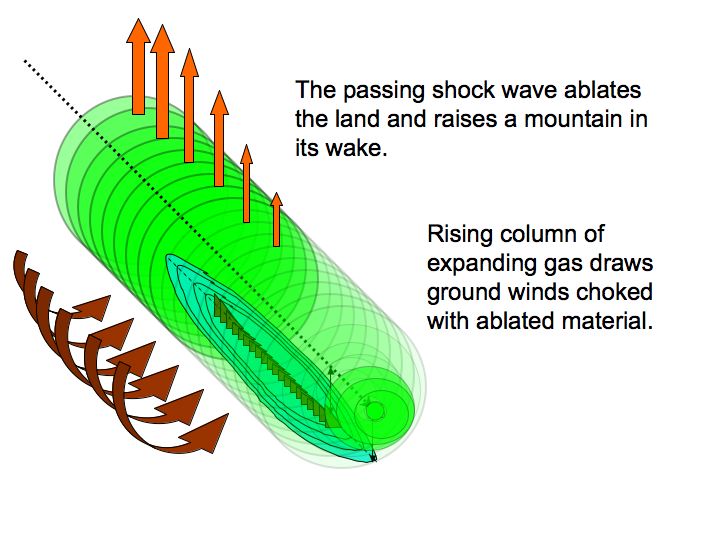
Furthermore, the powerful EMP electrical forces at work in the shockwave front will both excavating (vaporise) and liquify (energise) the rock to some extent as it plows forward.

The shockwave tail behind will result in Richtmeyer-Meshkov instabilities forming in its wake, an enormous vacuum zone which would not only draw into itself hypersonic winds, but also seek to pull up into itself the energised, softened and triangulated subterranean earth. Remember: liquids will get sucked up into a vacuum dependant primarily on their viscosity. Such a vacuum exists in the wake of a hypersonic wind event which would draw liquified sedimentary strata up into itself, so say nothing of atmospheric gases.

Figure 5. Richtmeyer-Meshkov Instability Profile [3]

Image[3]
Andy Hall wrote:The mushroom cloud rises behind the shock wave with a supersonic vacuum at its core. The updraft of expanding gases generates in-flowing ground winds that scream like banshees across the ablated surface of the blast zone, attaining supersonic speeds as they funnel to the core of the updraft, dragging clouds of molten rock and dust.
Following this vacuum zone is the secondary tail shock, depositing even smaller resonant triangles on the already-deposited larger ones (see Fig. 4 above).

Where the shockfront has first impacted with the land is where the greatest sudden upward subterranean curvature should be. In the context of the North American continent, this is where the Great Plains become the eastern Rockies. In context to the earlier Flood deposition layers, these have been literally bent skyward and vaporised (Fig. 2. demonstrates this point well) and re-deposited in various locations in downdraft bursts further south after being electrically sorted according to ionisation potential.

Notice there is a cut-off for the curvature depth where strata were bent skywards (Fig. 2): this corresponds to the petering out of the shockwave energies. The vacuum force was so strong, even underlying granite and gneiss (pink layer, Fig 2.) has been pulled upwards. So it may be the case that, instead of being continental overthrust pushing in from the west, the Rockies, stretching as far south as the Andes, represent a vacuumed-sucked mountain range formed after a single, calamitous event that hyper-ionised Earth's atmosphere. The storm was akin to what scours Jupiter daily.

It it can thus be argued that some significant mountain formations were simultaneously excavated, uplifted and redeposited in the same hypersonic wind event. The curved edges of the uplifted strata in Boulder and Colorado Springs (and beyond) testify to the fact they were both pulled up by the same hypersonic shockwave event which emanated from the north polar region and screamed south, lifting out the entire Rockies and Andes in the process.

Similar events have carved out the mountains of Iran, Pakistan and the Himalayas, primarily west-to-east in direction, as well as the MacDonnell ranges, Kata Djuta, Uluru, and other easily identifiable features in central Australia. There will be other features to be identified in Africa, particularly the Sahara, Morocco and Rift Valey regions.

I realise that much of this results from projectile shockwave physics, so if any objection is to be made it will probably be on this point. But the point of ionic hypersonic winds is that no projectile is required. A hyper-ionised atmosphere will create the electrical environment required to form these winds by themselves (no bolides required), just like what happens on Jupiter daily.

In the Psalm 114 it says of the Exodus event,

"When Israel went out from Egypt, the house of Jacob from a people of strange language, 
Judah became his sanctuary, Israel his dominion. 
The sea looked and fled; Jordan turned back. 
The mountains skipped like rams, the hills like lambs. 
What ails you, O sea, that you flee? O Jordan, that you turn back? 
O mountains, that you skip like rams? O hills, like lambs? 
Tremble, O earth, at the presence of the Lord, at the presence of the God of Jacob..."

Routinely dismissed by interpreters as 'flowery metaphor' (Velikovsky), I firmly believe the Psalmist is reminiscing on an ancient, eyewitness tradition of a time when the mountains did indeed skip like playing rams, flying up into the sky before coming down again in new places, just like the new sea fled from YHWH's presence. This Psalm, relating to the Exodus, relates a mountain-reshaping event that happened well after the time of the Flood.

There will be other traditions that confirm this fact, that some of the mountains are young and grew up in their place after some catastrophic event well after the time of the Flood.[4] We are the children of the survivors.

[1] A. Hall, "Arc Blast - Part 1," Thunderblogs, May 11, 2016; "Arc Blast - Part 2," Thunderblogs, May 21, 2016; "Arc Blast - Part 3," Thunderblogs, May 28, 2016.
[2] A. Hall, "Arc Blast - Part 1."
[3] A. Hall, "Arc Blast - Part 1."

Lloyd
Posts: 5428
Joined: Fri Apr 04, 2008 9:54 pm

Re: Creationism, Myth and Catastrophism

Unread post by Lloyd » Tue Mar 03, 2020 6:00 pm

JP, can you make an outline of your post/s to help simplify it for easier understanding?
_If you look at cross-sections of the Rockies, like here:
https://www.google.com/search?q=rockies ... 93&bih=524
you don't find diagonal strata on mountain sides that are different from the strata of the plains east and west of the Rockies.
_How could ionic winds leave the strata just as they are, except for making them diagonal instead of horizontal?
_Why would the ablated material in ionic winds from the plains strata not get all mixed together in forming the mountain sides?
_The reason the Colorado plateau etc are so high is that the North American plate hit and partly over-rode the East Pacific Rise when the asteroid broke up the supercontinent and the Americas slid over the Moho layer toward the west.
_The Pacific Rise caused resistance to the North American plate slide, which folded and raised mountains.
_Mike Fischer shows the Americas and the Pacific Rise at the bottom of this webpage https://www.newgeology.us/presentation4.html
_South America split off of Africa first, then North America, so South America slid farther than North America, which also was slowed down by the Pacific Rise, making the south Atlantic a lot wider than the North Atlantic.
_Setterfield said a lot of craters are formed by bolide impacts. Don't you think many craters on Earth and the Moon were formed by bolide impacts? And Fishcer shows a huge crater (from an asteroid) off of east Africa that appears to have split up the supercontinent.
_It's obvious that the Americas split off of the supercontinent, because the strata and fossils etc are identical on opposite shores of the Atlantic. And Mike shows a lot of other reasons that rapid continental drift must have occurred at http://NewGeology.us .
_The Bible doesn't mention anything like ionic winds that formed mountains, does it?

Lloyd
Posts: 5428
Joined: Fri Apr 04, 2008 9:54 pm

Re: Creationism, Myth and Catastrophism

Unread post by Lloyd » Wed Mar 11, 2020 5:33 pm

SOME PROOF OF CONTINENTAL DRIFT

My Old Blog
https://www.thunderbolts.info/forum/php ... ils#p94232

Gordon's Reply
https://www.thunderbolts.info/forum/php ... ils#p94238

Interview with plate tectonics expert Dr John Baumgardner
https://creation.com/probing-the-earths-deep-places

Geology Questions and Answers: What about continental drift?
https://creation.com/images/pdfs/cabook/chapter11.pdf

My Old Thread: Breakthrough on How Continents Divided
https://www.thunderbolts.info/forum/php ... 2&start=15

You can find good evidence for continental drift online, such as matching rock types, fossils and mountain ranges etc on opposite sides of the Atlantic, but they don't show very much of each. Looks like we need to buy a book or two on the subject to get significant info.

User avatar
JP Michael
Posts: 538
Joined: Sun Oct 27, 2019 4:19 am

Re: Creationism, Myth and Catastrophism

Unread post by JP Michael » Fri Mar 13, 2020 12:27 am

Lloyd wrote: Wed Mar 11, 2020 5:33 pmLooks like we need to buy a book or two on the subject to get significant info.
Yes I'm going to buy some books on this but not now. I have greater priorities at the moment than catastrophist geology, unfortunately. In my mind it is quite probably a combination of forces, not any single one. Geology will always falter by concentrating on a single model, be it impact, runaway subduction, flood-only, or hypersonic wind. I think, as we get closer to the truth, we will find multiple geological forces operating in different regions at different times and caused by different celestial events. That's what we need to be prepared to look for, and current creationist models are not doing this.

There is a great need in the world for polymaths. Knowledge has become grossly compartmentalised.

Lloyd
Posts: 5428
Joined: Fri Apr 04, 2008 9:54 pm

Re: Creationism, Myth and Catastrophism

Unread post by Lloyd » Mon Mar 16, 2020 12:24 am

2665

Proof a Mysterious Lost Ancient GLOBAL Civilization Spanned Virtually the Entire Planet
https://www.youtube.com/watch?v=BTd1fRCAvR

This video shows similar construction techniques and several mythical themes included in ancient constructions, statues etc. Some of the mythical themes are the uraeus or cobra, the caduceus, the pyramid etc. The evidence supports a global ancient civilization, which apparently came after the global Flood, since the Flood buried or washed away nearly all pre-Flood structures.

User avatar
JP Michael
Posts: 538
Joined: Sun Oct 27, 2019 4:19 am

Re: Creationism, Myth and Catastrophism

Unread post by JP Michael » Mon Mar 16, 2020 1:14 am

The thing is, Scripture does not support a global, united post-Flood civilisation. Noah & family disembarked in "Ararat" and soon after spread down to the Mesopotamian valley. It was here that the united Kingdom of Babel via Nimrod was established. This indeed was a (mostly) religiously unified civilisation, but entirely confined to the Levant, thus it cannot be considered "global". It was not until after the confusion of languages (which Velikovsky identifies with a catastrophic event involving the planet Mercury) that humanity spread across the globe, at least according to the Biblical chronology.

GHDW
Posts: 4
Joined: Mon Feb 17, 2020 2:29 am

Re: Creationism, Myth and Catastrophism

Unread post by GHDW » Mon Mar 16, 2020 4:02 am

Has anyone had a chance to check out the Diehold Foundation channel on youtube, there are a series of videos that cover the reason how and why the Younger-Dryas cooling event was triggered.
The basic outline is that the sun, and every star apparently, adheres to a 12,068 year cycle that Wolfgang Gleißberg discovered less than a century ago. At the end of the cycle the star emits a very large burst akin to a nova and this wreaks havoc on the rest of the solar system.
Researches have chimed in about finding quartz spheres all along the Atlantic ocean floor spanning between continents and theorize that a comet or meteor impact caused enough heat to form the spheres, but a double banded plasma burst from the sun could carry far more energy than needed to do the same. Plus every extinction level event could be squarely blamed on this cycle instead of the common impact model.

Lloyd
Posts: 5428
Joined: Fri Apr 04, 2008 9:54 pm

Re: Creationism, Myth and Catastrophism

Unread post by Lloyd » Mon Mar 16, 2020 1:17 pm

2683

Re:
Proof a Mysterious Lost Ancient GLOBAL Civilization Spanned Virtually the Entire Planet
https://www.youtube.com/watch?v=BTd1fRCAvR

The video doesn't say that the global civilization was united. Rather, peoples around the world shared the same technology and similar customs relating to mythology.

Re the Younger Dryas events, stellar novae would surely have very minor effects on the solar system. Bolide impacts are obvious and they would have electrical effects, including the explosions on impact, i.e. due to electrical repulsion between like charges.

GHDW
Posts: 4
Joined: Mon Feb 17, 2020 2:29 am

Re: Creationism, Myth and Catastrophism

Unread post by GHDW » Mon Mar 16, 2020 10:31 pm

stellar novae would surely have very minor effects on the solar system
That's quite a dismissive remark, no point in adding anything more.

Post Reply

Who is online

Users browsing this forum: No registered users and 1 guest