Are the planets growing?

Beyond the boundaries of established science an avalanche of exotic ideas compete for our attention. Experts tell us that these ideas should not be permitted to take up the time of working scientists, and for the most part they are surely correct. But what about the gems in the rubble pile? By what ground-rules might we bring extraordinary new possibilities to light?

Moderators: MGmirkin, bboyer

Locked
Aardwolf
Posts: 1330
Joined: Tue Jul 28, 2009 7:56 am

Re: Are the planets growing?

Unread post by Aardwolf » Tue Jul 13, 2010 8:20 am

Aromaz wrote:I am still reading and trying to catch up on previous postings, but guess that will take a week!
Please forgive me if these few points are duplicated.

African Rift:
It might be of interest to know there are actually two major N-S rift valleys in Africa.
This particular one through Ethiopia does actually stretch right over the Red sea and the most northern part is what is called Ubhor, slightly N from Jeddah in Saudia Arabia. In Ubhor which is only some 10 km long and on average 500 wide the depth reaches more than 1,800 meters. Ubhor is moving SE with slight arch, and movement seems to be linked with that of Eastern Ethiopia and Somalia.

The other rift is actually much bigger and prominent.
It starts in Egypt as the Nile river delta and runs all through Africa down to Swaziland in the South. This one is much older and current displacement slower than the Ethiopian rift.

On expansion of the Earth:
There is no doubt that the Earth is expanding; but this is result of a number of incidents.
Off course the most obvious are meteors.
Less realized and less accepted: Earth is bombarded by Cosmic radiation; including dust, neutrons, protons, electrons, etc.

Some of these Particle/Waves can penetrate very deep. The earth has a molten core – high temperature, thus all sub-atomic particles will also be exposed to heat, friction and most likely result in formation of physical particles, further bonding and eventually have Atoms. . . molecules.

On the water issue: Posibility of comets, but that I am not so sure would have been enough.
We should rather look into Sapce for the formation of water, after all; Earth is not the only planet with water.
We know space is filled with Hydrogen and Helium related elements; and we (think we) know how those formed.
The big question: Where does the Oxygen came from? How was Oxygen formed?
To have H and O bind to water molecule requires heat; and earth had pleny of that in the core for a very long time.

Another issue I saw earlier: Himalaya Mountains;
Looking at a radiology and radar image of the ocean floor - Particular the Indian and Pacific Oceans.

There are very clear signs to indicate two major events:
1. A direct hit from astral body in the Pacific - large 'hole' in the crust that is still trying to heal i.e. Ring of Fire.
2. A angular hit by astral body colliding/glancing with Earth from near Antarctica, glancing up East of Madagascar and pushing (current) India right into the Eurasian continent; before moving out to space again.

There is a lot of proof for this concept besides the obvious scars and marks on the ocean floor: The Geology of minerals (and particular gemstones) in Western India corresponds to that of Madagascar. That glancing force would have been massive, and the force with which India crashed into Eurasia is perfect explanation of the whole Himalaya region. Even the ripples across Northern India all very clear.

Often I guess the simplicity of things makes it difficult to accept the real potential.
Aromaz, you already answered where the water could potentially come from;

"...thus all sub-atomic particles will also be exposed to heat, friction and most likely result in formation of physical particles, further bonding and eventually have Atoms. . . molecules."

You dont need comets for water.

And we already know there is an abundence of water and hydrogen from the deep drilling wells, which came as a shock to most geologists who cannot satisfactorily explain how they got there.

Aromaz
Posts: 2
Joined: Mon Jul 12, 2010 7:36 pm
Location: Satahip., Thailand
Contact:

Re: Are the planets growing?

Unread post by Aromaz » Wed Jul 14, 2010 12:26 am

And we already know there is an abundence of water and hydrogen from the deep drilling wells, which came as a shock to most geologists who cannot satisfactorily explain how they got there.
@aardwolf; gratitude for your pointer about deep water and hydrogen. Regretfully my geophysic updates has been neglected in lieu of Energy pursuits. I follow up and found detailed info about Project "Kola Superdeep Borehole" - astonishing 12.262 km into the crust. From that I found a number of other usefull pages.

Fosils at 6,7 km depth with carbon and nitrogen covering instead of limestone and silica :!:

Makes one wish you can read faster and know more. Very interesting read! Thank you.
This does open a can of worms too.
----------------------------------------------------------------------------------
To overcome barriers by the conventional; one has to find the NEW.

Lloyd
Posts: 4433
Joined: Fri Apr 04, 2008 2:54 pm

Re: Are the planets growing?

Unread post by Lloyd » Wed Jul 14, 2010 8:37 am

INDIA
Aromaz: angular hit by astral body colliding/glancing with Earth from near Antarctica, glancing up East of Madagascar and pushing (current) India right into the Eurasian continent; before moving out to space again.
The Shock Dynamics view is that a large impact not only broke India off of Africa and pushed it against Asia to form the Himalayas, but also broke apart the entire supercontinent and pushed the continents to their present positions in a short period of time.
EUROPA
Some of the major cracks in the ice of Europa definitely show signs that the ice broke and moved apart, but there's no way to tell so far if ice in other locations moved under or over adjacent ice sheets, or buckled up etc.
EARTH MEASUREMENTS
It should be easy to determine if the Afar rift is actually evidence of Earth expansion or not. The laser measurements of the continents and the entire Earth should tell if the Earth is expanding. The measurements can supposedly detect movements of a centimeter or so. I think it would be big news if they would detect that the Earth is expanding.
OCEANS
Earth's water likely came from the polar plasma column, as the myths said the Great Flood came from the north etc and the north polar area was churned up miles deep by a great vortex centered on the pole, which vortex was connected to Saturn, Venus and possibly Mars during the Saturn Age. Before the flood there were no continents and no great oceans. Much of this comes from Cardona and or Talbott et al in Thoth ezine. If Earth is expanding from the inside the ocean levels should be dropping. If it's expanding from the outside, the oceans could be growing. I don't think the Earth is growing appreciably at all.
EARTH'S CENTER
The best evidence, as provided by Allyn earlier in this thread, is that Earth is hollow, with a gaseous or plasma center, no solid or liquid. So take that into consideration with regard to cosmic rays etc expanding the Earth from the inside. And, by the way, wouldn't expansion cause the hollow center to shrink?

Aardwolf
Posts: 1330
Joined: Tue Jul 28, 2009 7:56 am

Re: Are the planets growing?

Unread post by Aardwolf » Wed Jul 14, 2010 4:11 pm

Lloyd wrote:EARTH'S CENTER
The best evidence, as provided by Allyn earlier in this thread, is that Earth is hollow, with a gaseous or plasma center, no solid or liquid. So take that into consideration with regard to cosmic rays etc expanding the Earth from the inside. And, by the way, wouldn't expansion cause the hollow center to shrink?
No, if you were to heat say a metal ring to simulate expansion, all the metal would expand and so would the space in the centre. I imagine the same would be true for a sphere.

EDIT - The space would decrease in the middle if material were added to the inside only, but expanding earth scenarios add matter throughout the crust, expanding the sphere (if you assume it is hollow).

Anaconda
Posts: 460
Joined: Wed Apr 15, 2009 9:32 am

Re: Are the planets growing?

Unread post by Anaconda » Thu Jul 15, 2010 10:02 am

allynh, thank you for placing the images of Europa directly in the thread (nothing like having the images roll directly onto the screen as you read the thread to make a point) :)

From the NASA link on Europa:
In this false color image, reddish-brown areas represent non-ice material resulting from geologic activity.
Notice in the NASA images that the "reddish-brown" material is emanating from the cracks. This is entirely consistent with expansion.

Odds & Ends:

Prior in the thread, the issue of what caused the Rocky Mountains was raised as an objection to the Expanding/Growing Earth theory.

But actually, the Rocky Mountains are an anomaly to the so-called "subduction" model as stated by the USGS (United States Geological Survey):
The growth of the Rocky Mountains has been one of the most perplexing of geologic puzzles. Normally, mountain building is focused between 200 to 400 miles inland from a subduction zone boundary, yet the Rockies are hundreds of miles farther inland.
It's a "puzzle" to Standard Model geologists because it doesn’t conform with the so-called “subduction” paradigm — rather, it is an anomaly or contradiction.

Of course, the USGS article then goes on to attempt an explanation that reconciles the anomaly with the dogma:
What geologic processes raise mountains at this scale? Although geologists continue to gather evidence to explain the rise of the Rockies, the answer most likely lies with an unusual subducting slab.
http://www.nature.nps.gov/geology/usgsn ... kymtn.html

Although, the link even admits geologists don’t have the answers, “the answer most likely lies”, which is to say, “we speculate”, as to an answer.

The “unusual subducting slab” is pure speculation. Simply an unsupported attempt to salvage the “subduction” dogma.

allynh
Posts: 919
Joined: Fri Aug 22, 2008 5:51 pm

Re: Are the planets growing?

Unread post by allynh » Thu Jul 15, 2010 12:05 pm

Rocky Mountain System wrote: Raising the Rockies

The growth of the Rocky Mountains has been one of the most perplexing of geologic puzzles. Normally, mountain building is focused between 200 to 400 miles inland from a subduction zone boundary, yet the Rockies are hundreds of miles farther inland. What geologic processes raise mountains at this scale? Although geologists continue to gather evidence to explain the rise of the Rockies, the answer most likely lies with an unusual subducting slab.
contvsocn288x157.gif
contvsocn288x157.gif (7.53 KiB) Viewed 13408 times
Sketch of an oceanic plate subducting beneath a continental plate at a collisional plate boundary. The oceanic plate typically sinks at a fairly high angle (somewhat exaggerated here). A volcanic arc grows above the subducting plate.
shallowsubduct.gif
shallowsubduct.gif (8.79 KiB) Viewed 13408 times

This sketch shows the plate tectonic setting during the growth of the Rocky Mountains (Laramide orogeny). The angle of the subducting plate is significantly flatter, moving the focus of melting and mountain building much farther inland than is normally expected.
Anaconda wrote: The “unusual subducting slab” is pure speculation. Simply an unsupported attempt to salvage the “subduction” dogma.
Exactly.

seasmith
Posts: 2815
Joined: Thu Mar 27, 2008 6:59 pm

Re: Are the planets growing?

Unread post by seasmith » Thu Jul 15, 2010 3:16 pm

Not naysaying, justsaying,
It's an Electric Earth, but also a physical body with a skin:

More folds (Laramide orogeny), more surrounding strain (Kansas, Nevada). Get up on the peaks, ridges and clefts,
if wanting to see the electricity.

Jiangshui Huang and colleagues at the University of Massachusetts, Amherst explore how wrinkles in a sheet adapt to an edge that prefers to be flat. They float a thin, rectangular film of common plastic (polystyrene) on water and compress the sheet along one direction to make folds. In the middle of the film, competition between gravity (which prefers shallow, frequent ripples) and the energy cost of bending the film (which favors longer, higher folds) determine the height and frequency of the folds. Near the edge, however, surface tension forces the film to lie flat. Huang et al. show the film interpolates between these two limits by smoothly tapering from larger, undulating folds in the center to higher frequency ripples at the edge.
In a related paper, Douglas Holmes and Alfred Crosby, also at the University of Massachusetts, Amherst quantify the transition from soft wrinkles to sharper folds. Similar to lifting a tissue from a box, they pull up an elastic sheet floating in water, and image the sheet as first wrinkles, and then folds, appear. They show that folds, like the edges of a neatly made bed, strain the sheet and smooth out the wrinkles.
http://www.nanowerk.com/news/newsid=171 ... oo%21+Mail

allynh
Posts: 919
Joined: Fri Aug 22, 2008 5:51 pm

Re: Are the planets growing?

Unread post by allynh » Thu Jul 29, 2010 2:16 pm

In reading through the Maxlow site again, he mentions basing his globes on the Bedrock Geological Map of the World from 1990. I haven't found that one but I did find the site where the latest versions are.

Commission for the Geological Map of the World
http://ccgm.free.fr/

Geological Map of the World
http://ccgm.free.fr/cartes_monde_gb.html
carte_geol_monde-02.jpg
carte_physio_monde_02.jpg
Explanatory Notes in English
http://ccgm.free.fr/doc/Expl%20Notes%20 ... 0World.pdf

Plus the Geological Time Scale 2008 chart
http://ccgm.free.fr/charte_gb.html
charte08_icone_recto.jpg
charte08_icone_recto.jpg (28.09 KiB) Viewed 13317 times
charte08_icone-verso.jpg
charte08_icone-verso.jpg (17.36 KiB) Viewed 13317 times

allynh
Posts: 919
Joined: Fri Aug 22, 2008 5:51 pm

Re: Are the planets growing?

Unread post by allynh » Mon Aug 16, 2010 8:02 pm

I was going to do a book report for Terra non Firma Earth: Plate Tectonics is a Myth by Dr. James Maxlow, then realized that he has already essentially done so on his website. This is the text.
Expansion Tectonics Explained
http://www.jamesmaxlow.com/main/index.p ... sition=4:4

You can download a pdf version of this page here.

By James Maxlow

One of the most profound statements the late Professor Sam Warren Carey (Emeritus Professor of Geology from the University of Tasmania) said to me when I first started researching Expansion Tectonics was: If 50 million believe in a fallacy it is still a fallacy. The point he was making was that the validity of any theory does not depend upon the number of people believing it; hence, an accepted theory may still be fundamentally wrong regardless of how many people believe it is correct.

The Plate Tectonic interpretation of global data, for instance, is based on the fundamental premise that the Earths radius has remained constant, or near constant, throughout history. As will be outlined in this paper, this contrasts with an Expansion Tectonic interpretation of the same global data which is based on the fundamental premise that the Earths radius has been steadily increasing throughout Earth history.

It should be appreciated from this statement that all modern and historical global data used to substantiate both Plate Tectonic and Expansion Tectonic theories are, in fact, identical. The only reason why Plate Tectonic theory won acceptance 50 years ago was because debate on whether or not Earths radius does or does not change with time was largely hypothetical – since it couldn’t be convincingly verified or measured.

Since then there has been a quantum leap in both technology and peoples understanding of our physical Earth, ranging from the introduction of computers, modern data gathering and processing capabilities, advances in software, satellite technologies, media presentation and, of course, increased public awareness of global tectonic principles.

The timing of my initial research into Expansion Tectonics was both fortunate and critical. Completion of the published Bedrock Geological Map of the World used in my model studies (Figure 2) coincided with commencement of my research during the early 1990s. Without this world mapping, Expansion Tectonics would have continued to remain in the dark ages. In addition, computer and software technology has also caught up with the need to present Expansion Tectonic Earth models and supporting time constrained data on spherical Earth globes.

The most important outcomes of my Expansion Tectonic research to date are:
  • Modeling of continental plate assemblages has now been completed for 100% of geological Earth history, ranging from the early Archaean Era to the present day. These assemblages have demonstrated a high degree of crustal fit accuracy and, most notably, without the need to arbitrarily fragment continents or dispose of pre-existing crusts by subduction.

    A formula for rate of change in Earth radius has been established and modeling of physical data completed. This mathematical modeling demonstrates that Earth radius has been increasing exponentially throughout time, increasing to a current rate of 22mm/year.

    Ancient magnetic poles plus equator have been accurately located on all models constructed. Both poles plot as diametrically opposed north and south poles, enabling the ancient equators and climate zones to be precisely established.

    Geological, geographical and geophysical data have been investigated on all models. These data are shown to coincide precisely with expected polar and equatorial climatic and biotic constraints.

    Models have been animated in four dimensions, showing the increase in Earth radius throughout time along with global distribution of selected data sets.
Geology and the Rock-Record

Geology (from Greek: gê, "Earth"; and logos, "speech") literally means to talk about the Earth and is defined as the science and study of the solid matter that constitutes the Earth. To me this definition must also go a step further to acknowledge the rocks making up the Earth are, in fact, a record of the physical processes affecting the Earth throughout its entire history. It is like an open book waiting to be read. To understand and talk about the “rock-record” preserved in rocks you therefore need to understand the language of geology.

James Hutton is often viewed as the first modern geologist. In 1785 he presented a paper entitled Theory of the Earth to the Royal Society of Edinburgh. In this paper he suggested the Earth must be much older than previously supposed in order to allow enough time for mountains to be eroded and for sediments to form new rocks at the bottom of the sea, which in turn were raised up to become dry land. Hutton published a two-volume version of his ideas in 1795.

Since then our knowledge of geology has extended world wide, with a vast amount of global geological, geographical and geophysical data stored and published for all to use and interpret. The primary concern during my early research into Expansion Tectonics was this modern data has never been tested on models of an expanding Earth. Our perception of global tectonic principles was, and still is, severely biased towards Plate Tectonics at the expense of alternative theories.

Historical ways of viewing the Earth

Many theories have come and gone throughout the past millennia, in particular after the science of geology was formally recognized. The Flat Earth theory, popular in ancient times is now largely historical, but it serves as a useful starting point in understanding the progression of our knowledge about the Earth through history. This concept stems from the limited knowledge of the size and configuration of the Earth in ancient times, and, of course, the limited number of “scientists” or philosophers capable of gathering enough information to make meaningful sense of the knowledge available.

The suggestion that continents have not always been at their present positions was introduced as early as 1596 by the Dutch map maker Abraham Ortelius. Ortelius suggested, based on the symmetric outlines of the Atlantic coastlines, the Americas, Eurasia and Africa were once joined and have since drifted apart "by earthquakes and floods", creating the modern Atlantic Ocean. For evidence, he wrote: "The vestiges of the rupture reveal themselves, if someone brings forward a map of the world and considers carefully the coasts of the three continents."

By 1915, Alfred Wegener was presenting serious arguments for the idea of “continental drift” in the first edition of his book The Origin of Continents and Oceans. In this book he noted how the east coast of South America and the west coast of Africa looked as if they were once attached. While Wegener wasn't the first to note this, he was the first to gather significant fossil and geological evidence to support this simple observation. His ideas, however, were not taken seriously by most geologists of that period, who pointed out there was no apparent mechanism for “continental drift” as it was then called. Specifically, they did not see how continental rock could possibly plow through the much denser rock that makes up oceanic crust.

It is interesting to note that in 1958 Professor Sam Carey, in researching the concept of continental drift, made scale models of the Earth and demonstrated “if all the continents were reassembled into a Pangaean configuration on a model representing the Earths modern dimensions, the fit was reasonably precise at the centre of the reassembly and along the common margins of north-west Africa and the United States east coast embayment, but became progressively imperfect away from these areas”. Carey concluded from this research that the fit of these ancient continents “could be made much more precise in these areas if the diameter of the Earth was smaller at the time of Pangaea”. With the acceptance of Plate Tectonics, these basic physical observations and conclusions of Carey have been totally ignored.

During this same time there were a number of independent thinkers who instead considered the opening of the oceans could be attributed to an increase in Earth radius. Roberto Mantovani in 1889, and again in 1909, published a theory of “earth expansion and continental drift”. In this theory he considered a closed continent covered the entire surface on a smaller Earth. He suggested “thermal expansion led to volcanic activity, which broke the land mass into smaller continents”. These continents then drifted away from each other because of further expansion at the “rip-zones”, where oceans currently lie. This was followed by the pioneering work and publications of Lindemann in 1927, Christopher Otto Hilgenberg during the 1930s, Professor Sam Carey during the 1950s to late 1990s, Jan Kozier during the 1980s, and Klaus Vogel during the 1980s and 1990s.

These researchers all showed if each of the continents were physically fitted together they would neatly envelope the Earth with continental crust on a small Earth globe some 55 to 60% of its present size. This coincidence led Hilgenberg, Carey, and Vogel in particular to conclude “terrestrial expansion brought about the splitting and gradual dispersal of continents as they moved radially outwards during geological time”.

The perceived failings and short falls of each of these theories, however, eventually led to an acceptance of Plate Tectonic theory in the 1960s. This theory is now credited to have arisen out of the hypothesis of continental drift, as first proposed by Alfred Wegener.

Most of us are now reasonably familiar with the concept of Plate Tectonics, whereby the Earths outer crust is said to be made up of a series of large, rigid, plate-like crusts that randomly move over the Earths surface under the influence of mantle convection currents. In the process of random migration, the crustal plates are said to rift, slide past one another, and/or periodically collide to form mountains and subduct beneath continental crusts. The primary assumption and absolute basis of Plate Tectonics is that the radius of the Earth has remained constant, or near constant throughout its 4,500 million year life span.

Contributions to Modern Tectonic Theory

In 1947, a team of scientists, led by Maurice Ewing, utilizing the Woods Hole Oceanographic Institution’s research vessel Atlantis, confirmed the existence of a rise in the level of the sea floor in the central Atlantic Ocean, now known as the mid-ocean-ridge. They also found the floor of the seabed beneath the layer of sediments consisted of basalt, not granite as previously assumed; which is one of the main constituents of the continents. They also found the oceanic crust to be much thinner than continental crust. All of these new findings raised important and intriguing questions about the way we perceive oceanic crust. The most important of which was that the ocean is not simply “oceanised” continental crust covered by sea water, as previously thought.

Beginning in the 1950s, scientists, using magnetic instruments (magnetometers) adapted from airborne devices developed during World War II to detect submarines, also began recognizing odd magnetic patterns across the ocean floor. This finding, though unexpected, was not entirely surprising because it was known that basalt - the iron-rich, volcanic rock making up the ocean floor, contains a strongly magnetic mineral called magnetite, which can locally distort compass readings. More importantly, because the presence of magnetite gives the basalt measurable magnetic properties, these newly discovered magnetic sea floor patterns provided an important means to study the distribution of volcanic rocks throughout each of the ocean floors.

As more and more of the seafloor was mapped during the 1950s, the magnetic patterns turned out not to be random or isolated occurrences, but instead revealed recognizable zebra-like stripes, found to be symmetrical about the mid-ocean-ridges. Alternating stripes of rock were shown to be laid out in parallel rows on either side of the mid-ocean ridge - one stripe with normal polarity and the adjoining stripe with reversed polarity. The overall pattern, defined by these alternating bands of normally and reversely polarized rock, became known as magnetic striping.
MidOcean.jpg
Figure 1: Symmetrical magnetic stripping across part of the Atlantic Ocean mid-ocean-ridge.
The discovery of this symmetrical magnetic striping pattern suggested a close relationship between the mid-ocean ridges and the stripes. In 1961, scientists (most notably the American geologist Harry Hess) began to theorize that the mid-ocean ridges mark structurally weak zones, where the ocean floor was being ripped apart lengthwise along the mid-ocean ridge crest. It was suggested new volcanic magma from deep within the Earth must rise through these weak zones and eventually erupt along the crest of the ridges to create new oceanic crust. This process, later called seafloor spreading, operates over many millions of years and continues to form new ocean floor all along the 60,000km-long system of mid-ocean ridges now known to be present in all of the oceans.

This hypothesis was supported by several lines of evidence. At or near the crest of the mid-ocean-ridges the rocks are very young, and they become progressively older away from the ridge crest. The youngest rocks at the ridge crest always have present-day (normal) polarity. Stripes of rock parallel to the ridge crest were shown to have alternated in magnetic polarity (normal-reversed-normal, etc.), suggesting the Earths magnetic field has reversed many times throughout its history.

By explaining both the zebra-like magnetic striping and the construction of the mid-ocean ridge system, the seafloor spreading hypothesis quickly gained converts. Furthermore, the oceanic crust now came to be universally appreciated as a natural "tape recording" of the history of the reversals in the Earths magnetic field.

Subsequent work by the Commission for the Geological Map of the World and UNESCO during the 1980s led to the publication of the “Bedrock Geological Map of the World” in 1991. In this global map, the magnetic striping discussed above was taken a step further. By dating the ages of the ocean floor bedrock at regular intervals throughout each of the oceans, and comparing these ages with the magnetic striping, the ocean floor crust was then displayed according to the ages of the rocks.

What this means is the yellow stripes in Figure 2, for instance, located between the younger red stripe and the older orange strip, represents volcanic rocks that were erupted along the ancient mid-ocean-ridges during the Miocene Period, a period of time extending from 6 to 23 million years ago. At that time the younger red and pink rocks did not exist and the two yellow Miocene stripes were joined together along their common mid-ocean-ridge.
SeabedAges.jpg
Figure 2: Bedrock geological map of the world (Commission for the Geological Map of the World and UNESCO, 1991).
Important Considerations

At this stage there are a number of very important considerations about the crustal mapping shown in the above figures that must be fully appreciated.
  • Firstly, the striping shown in Figure 2 shows that each of the oceans contain a mid-ocean-ridge (currently centred below the pink stripes) and each ocean is increasing its surface area with time. This increase in surface area is shown to be symmetrical within each ocean and the maximum age of exposed sea floor crust is early Jurassic – about 165 million years old (pale blue areas).

    Secondly, if it were possible to move back in time, each of the stripes shown in both Figures 1 and 2 must be successively removed and the corresponding edges of each coloured stripe must be moved closer together as we move back in time – that is, the volcanic rocks (and similarly the ocean waters) within each stripe must be returned to the mantle where they originally came from.

    Thirdly, as we move back in time, each of the continents must move closer together in strict accordance with the striping evidence recorded on the map in Figure 2 regardless of which tectonic theory is adhered to.
    Fourthly, subduction of crusts beneath continents is an artifact of the basic Plate Tectonic requirement for a constant Earth radius. The symmetrical striping evidence shown does not support subduction and subduction is not required if the Earth were increasing its radius.

    It should also be appreciated that none, or very little of this magnetic striping and age dating evidence was available when Plate Tectonic theory was first proposed. The global distribution of the magnetic striping and age dating was, in fact, completed later in order to quantify the plate motion history and, therefore, the Plate Tectonic history of each ocean.
Comparison of Expansion Tectonics and Plate Tectonics

As previously stated, the primary global geological, geographical and geophysical evidence used to quantify both Plate Tectonic and Expansion Tectonic theories is identical. The difference between each theory simply boils down to whether or not the presumed need for a constant Earth radius premise is true or false.

In Plate Tectonic theory it is presumed the radius of the Earth has remained essentially constant with time. As new volcanic rocks are injected along the mid-ocean ridge spreading axes the ocean floors widen allowing newer oceanic crust to form. To maintain a theoretical constant radius Earth, an equal amount of pre-existing oceanic or continental crust must then be disposed of elsewhere and returned to the mantle by a theorized process called “subduction”. This subduction process forms the basis for Plate Tectonic theory, and consequentially is essential for maintaining a static radius Earth premise.

Alternatively, for an Expansion Tectonic Earth, the very same volcanic rocks injected along the mid-ocean ridge spreading axes again widen and add to the surface area of ocean floor. For an Expansion Tectonic Earth, this increase in surface area of all ocean floors is a reflection of an increase in Earth radius, and there is therefore no requirement for any net disposal of excess crust by subduction processes.

For an Expansion Tectonic Earth, prior to about 200 million years ago the modern ocean basins did not exist. At that time all continental crust was united to form a single supercontinent called Pangaea, enclosing the entire ancient Earth at about 52% of the present Earth radius. Instead of the modern oceans, a network of relatively shallow seas covered low lying parts of the Pangaean supercontinent. All of the relatively young ocean floor volcanic crusts, as well as much of the ocean waters and atmosphere, were retained within the mantle, where they originated.

While arguments can be given for and against both theories, it is emphasized that the exact same crustal fragments making up both the ancient supercontinents and modern continents can be fitted together precisely, somewhat like a spherical jigsaw, on a smaller radius Earth to form a single supercontinent. The question that must then be answered is, is this empirical phenomenon fact or mere coincidence?

Overview of Expansion Tectonics

Acceptance of Expansion Tectonics as a viable tectonic process is currently envisaged by many researchers to be thwarted by major obstacles, which supposedly “outnumber the evidence in favour”. These opinions are based on very outdated, and arguably emotive and opinionated research carried out during the 1950s to 1970s, well before the advent of modern Plate Tectonics, computer technology, global data gathering capabilities and multimedia communication. Unfortunately, these same outdated opinions are being carried through to recent literature, without proper scientific investigation, regardless of new advances made in Expansion Tectonic research.

Expansion Tectonic theory simply removes one primary premise from current tectonic theory –namely the assumption that the Earths radius is constant. By removing this premise we are then in a position to apply correct scientific principles to test whether the global data is, in fact, better explained on an Earth undergoing an increase in radius with time.

The completion of oceanic magnetic mapping and age dating of crust beneath all of the Earths major oceans (Figure 2) has provided a very important tool to quantify Expansion Tectonics. This ocean floor mapping has placed finite time constraints on the plate motion history shown in all the oceans extending back to before the Early Jurassic period (to about 200 million years ago). This mapping is used in Expansion Tectonics to quantify both plate reconstruction and rate of crustal generation on small Earth models.

A set of eleven spherical models, extending from the early Jurassic Period to the present, is shown in Figure 3. These models have since been extended back in time to the early Archaean Era (about 4,500 million years ago) and one model projected to five million years into the future (models not shown here).

To construct each of the models, successively older geological time stripes paralleling the mid-ocean spreading ridges (Figure 2) are simply removed. Each crustal plate is then restored to a pre-spreading, or pre-extension configuration at a reduced Earth radius along their common plate or continental margin respectively. By successively removing young oceanic crust and reuniting the continental and oceanic plates along their common mid-ocean-ridges, each of the models shown in Figure 3 demonstrates a better than 99% plate fit-together.
JamesFig3Tease_2.jpg
Figure 3: Spherical Archaean to future Expanding Earth models. Models show relative increase in Earth radii during Earth history, and include both continental and oceanic geology. Models range in age from the late Archaean to Recent, plus one model projected 5 million years into the future. (Geology after the CGMW and UNESCO bedrock geology map, 1990). Click here to see a bigger version of this figure.
On these models, during the Triassic period (the time period before the Jurassic), continental crust, as well as sediments deposited around the continental margins, are then shown to envelope the Earth as a complete continental shell at about 52% of the present Earth radius. At that time the sediments along the continental margins (shown as white in Figure 3) formed a global network, representing the location of shallow seas surrounding and on-lapping the ancient continental lands.

This unique fit-together of the lands and an ancient sea demonstrates that Expansion Tectonics is indeed a viable process. By modeling oceanic and continental crusts on a reduced radius Earth model it effectively removes the need to arbitrarily fragment continents to maintain a constant Earth radius. It also removes the need to dispose of excess oceanic crust by subduction when opening each of the modern oceans.

Go to part two
Last edited by allynh on Mon Aug 16, 2010 8:07 pm, edited 1 time in total.

allynh
Posts: 919
Joined: Fri Aug 22, 2008 5:51 pm

Re: Are the planets growing?

Unread post by allynh » Mon Aug 16, 2010 8:05 pm

Part two.

http://www.jamesmaxlow.com/main/index.p ... sition=7:4
Geological, Geographical and Geophysical Evidence

All rocks contain an immense amount of geological, geographical and geophysical evidence which, to the trained eye, has a complex but variable history of formation, metamorphic change, chemical and erosive weathering, climatic influence, biotic activity and metallic worth to tell us. Using the models shown in Figure 3 we now have a platform on which we can piece together this physical evidence so as to locate the ancient poles and equators, distributions of exposed lands, mountains, ice-caps, seas and shorelines, the distribution, dispersal patterns and extinction histories of flora and fauna, the ancient climatic zones - ranging from polar ice-caps to equatorial zones, and the formation and distribution of metallic and hydrocarbon resources.

Ancient Magnet Poles

The published ancient magnetic pole information (the location of ancient magnetic poles established from measuring the remnant magnetism in iron-rich rocks) in particular provides conclusive evidence in support of Expansion Tectonics. When this magnetic pole data is plotted on Expansion Tectonic models it demonstrates that all pole data plot as diametrically opposed north and south poles for each model.

These models show that the ancient North Pole was located in eastern Mongolia-China throughout the Precambrian and Paleozoic Eras. As the continents slowly migrated south, during subsequent increase in Earth radius, there was an apparent northward polar wander through Siberia to its present location within the Arctic Ocean. Similarly, the ancient Precambrian and Paleozoic South Pole was located in west central Africa, and, as the continents slowly migrated north, there was an apparent southward polar wander along the South American and West African coastlines to its present location in Antarctica.

The locations of these magnetic poles, as well as the derived ancient equators, independently confirm the model reconstructions shown in Figure 3 and again suggest that Expansion Tectonics is indeed a viable process.
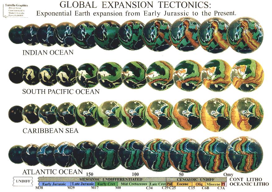
Ancient Geography

The ancient geography of the Earth forms the basis for defining the inter-relationships of exposed continents, intervening seaways, mountains and crustal movements, and enables the conventional Pangaea, Gondwana, Laurentia, Baltica, Laurussia and Rodinia supercontinents to be quantified on an Expansion Tectonic Earth.

The ancient coastlines, when plotted on Expansion Tectonic models, show that large Panthallassa, Tethys and Iapetus Oceans are not required during reconstruction. This is because on an Expansion Tectonic Earth all modern oceans are removed and continents are assembled as a single continental crust. These inferred oceans are instead replaced by smaller Panthallassa, Tethys and Iapetus Seas located on or between the ancient continents.

The early Panthallassa and Iapetus Seas developed during the Early Permian to Early Jurassic periods (260 to 165 million years ago) and initiated as shallow sedimentary basins within the present north-west Pacific and North Atlantic Ocean regions respectively. These then progressively opened and extended throughout the Mesozoic and Cenozoic Eras as the modern Pacific and Atlantic Oceans. In contrast, the Tethys Sea had its origins during the Early Precambrian Era as a continental sea located within what is now Europe and Asia. This sea then progressively enlarged and extended in area during the Precambrian, Paleozoic and Mesozoic Eras during crustal extension and subsequent opening of the modern oceans.

Changes in sea-level on an Expansion Tectonic Earth is then shown to occur in response to climatic change, as well as a shift in the distribution of continental seas, to crustal movements, mountain building, erosion, opening of the post-Permian modern oceans and production of new water at the mid-ocean-ridges. These changes all modified the ancient coastal outlines and resulted in a change in the exposed continental land areas. This is confirmed by the distribution of climate-dependant sedimentary rocks such as limestone reefs, and the distribution of climate-dependant marine and terrestrial fossil species.

Reconstructions of the conventional Pangaea, Gondwana and Rodinia supercontinents and smaller sub-continents on an Expansion Tectonic Earth demonstrate that, instead of being the result of random dispersion-amalgamation or collisional events, each continental assemblage is progressive, and represents an evolutionary crustal-forming process. The distinguishing feature of continents constructed on each Expansion Tectonic model is the inter-relationship of continental sedimentary basins, the network of continental seas and network of crustal movements. The variation of each of these in time has resulted in changes to the distribution of exposed continental land. Supercontinent configuration is then defined by a progressive extension of continental sedimentary basins, by ongoing crustal movements, and changes in sea-levels as the modern oceans opened and rapidly increased in area to the present-day.

Ancient Biogeography

On an Expansion Tectonic Earth the locations of fossilized fauna and flora can be used to illustrate their distribution in relation to the ancient lands and seas, and once again to confirm the established climatic zones as well as the poles and equator.

The distribution of various marine fauna, such as the Cambrian and Ordovician trilobites for instance, on an Expansion Tectonic Earth demonstrates the ease and simplification of migration routes and their development during the Palaeozoic Era. Barriers to the migration of trilobites, as well as other related species on an Expansion Tectonic Earth are then simply seen as limited to deep-marine restrictions and, to a limited extent, on latitude and climate extremes.

Triassic to Cretaceous dinosaurs, when plotted on Expansion Tectonic Earth models show dinosaur distributions are clustered within three distinct provinces, which coincide with the distribution of ancestral Permian reptiles; their ancient ancestors. These include distributions clustered in the European to Mediterranean region, distributions clustered in central and eastern North America and, distributions clustered in adjacent South Africa and southern South American regions, with links to India. Isolated related distributions also occur in east Australia, south China, and western South America.

The distribution of dinosaurs and ancestral Permian reptiles on an Expansion Tectonic Earth demonstrates the close links between Permian, Triassic and Jurassic species. This link was then disrupted during the early Permian during the initiation of continental break-up, and similarly during the Cretaceous as the various seas merged and sea levels began to rise. As the continents progressively broke up and dispersed there was a marked disruption of established climatic zones, as well as the feeding habitats and migration routes of each endemic species.

The extinction of the dinosaurs is a contentious issue. On an Expansion Tectonic Earth the Cretaceous period coincides with a period of enlargement of continental seas accompanied by a rise in sea-level, an increase in the size of the modern oceans and progressive disruption to climate. Sea levels peaked on the continents during the Late Cretaceous followed by a rapid draining of continental seas as the modern oceans continued to open.

Expansion Tectonic Earth models suggest there may have been two or more separate oceans existing during the Mesozoic era, with the possibility of separate sea levels. Rifting and merging of these oceans coincides precisely with faunal and floral extinction events at the end of both the Triassic and Cretaceous periods. This suggests the cause of the dinosaur extinction, which incidentally occurred over a period of 8 to 10 million years, may be linked with periods of relatively rapid sea level change some 65 million years ago, rather than a speculated asteroidal impact event as currently proposed.

The ancient Permian Glossopteris fern is a common fossil in coals throughout the southern hemisphere and has traditionally been used to define the ancient Gondwana supercontinent. The known distribution of Glossopteris ferns is centred on localities in South Africa and adjacent India. During the Permian period East Antarctica straddled the equator adjacent to South Africa, which was surrounded by occurrences of Glossopteris flora in Australia, West Antarctica and India, suggesting Glossopteris flora may have also been extensive beneath the present East Antarctica ice-cap.

The distribution of Permian Glossopteris ferns, when plotted on Expansion Tectonic models, straddles the ancient equator and ranges from high-northern to high-southern latitudes. This suggests Glossopteris ferns were tropical to cool temperate species, confirmed by the fossil evidence, which shows a Gondwana climate commencing with an ice-age and passing through a cold, but wet temperate to warm temperate climate during the Late Paleozoic Era.

These ancient biogeographic examples, while limited, briefly illustrate the ease and simplification of migration and development of all faunal and floral species on an Expansion Tectonic Earth. The inter-relationships of global and provincial distributions are then intimately maintained without the need for complex conventional continental assemblage-dispersal requirements.

During continental break-up and opening of the modern oceans on an Expansion Tectonic Earth, the distributions of species and migration routes were disrupted, forcing species endemic to the various regions to interact, extend their boundaries, fragment or simply become extinct with time. The timing of ocean development in many of these areas is also reflected in the changes in sea-level, facilitating marine faunal migration by extending and expanding immigration routes and moderating climatic differences.

Ancient Climate

The ancient climate on Expansion Tectonic Earth models can be investigated by plotting the distribution of selected climate-dependant rocks and comparing the distribution patterns with the location of established ancient poles and equators. Correlation of coal swamps, thick sandstone sequences and glacial rocks are excellent indicators of wet climates, while dry climates are indicated by evaporates, such as salt deposits, and equatorial regions by limestone reefs.

The glacial record shows four major glacial eras, including the Early Proterozoic Era, the Late Proterozoic Era, the Early and Late Paleozoic Era and the Late Cenozoic Era. The distribution of glacial deposits on an Expansion Tectonic Earth is also useful in checking the location of established magnetic poles and equators plotted from magnetic data.

The distribution of many of these Precambrian marine glacial deposits, many of which occur in conjunction with equatorial limestone and iron-rich rocks, is an enigma for Plate Tectonic reconstructions. In contrast, on an Expansion Tectonic Earth the relatively short pole to equator distances existing during this time allowed sea-ice to readily float into equatorial regions, depositing glacial rock debris amongst the existing warm climatic rocks as it melted.

The distribution of Early and Late Paleozoic glacial deposits coincides with a South Pole located in west central Africa, with isolated mountainous ice-centres located in Europe, Australia and South America. A northward shift in climate zonation and an absence of a permanent north polar ice-cap is a prominent feature of glacial, carbonate and coal distributions at that time. This northward shift suggests an Earth rotational axis, inclined to the pole of the ecliptic, was well established by the beginning of the Paleozoic Era and has remained at a similar inclination to the present-day.

The distribution of Paleozoic, Mesozoic and Cenozoic oil and gas resources coincides with the development of major continental and marginal basin settings. A broad zonation of deposits is evident from this distribution which straddles the established ancient equator and extends from low-southern to mid-northern latitudes. This distribution again suggests a northward shift in climatic zonation.

When viewed in context with global and local sea-level changes, oil and gas development coincides with periods of rising sea-levels and maximum surficial areas of continental seas. The Cretaceous in particular coincides with a period of post-Late Paleozoic glacial melting, a rapid opening of the modern oceans, generally warm climatic conditions and rapid biotic diversification.

The Early to Late Cretaceous distribution of coal shows two broad temperate belts located north and south of the ancient equator. On an Expansion Tectonic Earth a latitudinal shift in coal deposition through time is reflected in the rapid opening of each of the modern oceans, and similarly in the northward migration of continents during the Mesozoic and Cenozoic Eras. The predominance of coal deposits in the northern hemisphere is here attributed to the greater extent of landmass influencing rainfall and to the extent of remnant continental basins suitable for coal formation.

The distribution of all latitude dependent rocks on Expansion Tectonic Earth models is shown to coincide precisely with the ancient equators established from magnetic pole data. In each case a distinct latitudinal zonation paralleling the palaeoequator is evident, and a distinct northward shift in climatic zonation consistently suggests that an inclined Earth rotational axis, inclined to the pole of the ecliptic, was well established during the Palaeozoic persisting to the Recent.

Further Considerations

When presenting Expansion Tectonics a number of very valid and pertinent questions invariably arise which must be addressed. In doing so, however, it must be remembered Expansion Tectonics is based solely on the best explanation of existing empirical geological evidence. It is not a theory seeking physical support. It is rather a concept proposed which best fits all existing physical geologic data in a much superior manner than does the Plate Tectonic approach. To some extent it’s like a laboratory experiment wherein an unexpected observation is made that is not explained using existing physics. It then begs for extended theoretical models to explain the newly discovered physical facts.

What is causing the Earth to expand?

The entire question as to where the additional mass comes from to explain an increase in Earth radius is a very important core issue to Expansion Tectonics, but a very difficult question to answer. Because the Earth has always been considered the same size since creation; from either a cosmological or religious point of view, it has not been necessary to ask this question. Because the question has not been asked, or taken seriously, where the additional mass comes from remains speculative.

Since the theory of Earth expansion was first proposed in the late 1890s, five main re-occurring themes for the cause of Earth expansion have been suggested. These can be summarized as:
  • A pulsating Earth, where cyclic expansion of the Earth is said to have opened the oceans and contractions have caused orogenesis (mountain building). This proposal fails to satisfy exponential expansion, as shown by modern oceanic mapping, and Professor Carey considered the theme to have arisen from the false misconception that mountain building implies crustal contraction. In addition, Carey saw no compelling evidence for intermittent contractions of the Earth.

    Meteoric and asteroid accretion. This is currently a popular theory, proposed also to explain some of the various extinction events that have plagued the Earth. It basically says expansion is caused by an accumulation of extraterrestrial debris over time. This theme was rejected by Carey as the primary cause of Earth expansion, since expansion should then decrease exponentially with time, not increase as shown by the oceanic mapping. Nor does it explain ocean floor spreading, or the distribution of oceanic crust or covering sediments.

    Constant Earth mass, with phase changes of an originally super-dense core. This was again rejected by Carey as the main cause of Earth expansion because the theme implied too large a surface gravity throughout the Precambrian to Late Paleozoic Eras. A large Precambrian surface gravity was not evident from studies carried out during the 1970s. For a constant Earth mass, density would have also been unacceptably high during the Precambrian.

    Secular reduction of the universal gravitation constant G. Such a decline of G was said to cause expansion through the release of elastic compressional energy throughout the Earth, and phase changes to lower densities in the mantle. Carey rejected this proposal as the main cause of expansion for three reasons: (a) formerly the surface gravity would have been unacceptably high, (b) the magnitude of expansion is probably too small, and (c) the arguments for such a reduction in G were considered not to indicate an exponential rate of increase in radius.

    A cosmological cause involving a secular increase in the mass of the Earth. This suggestion remains the most popular theme.
Where the required excess mass came from was considered at length by Professor Carey. Knowing Einstein’s equation E=mc2 implies that matter and energy are inter-convertible. Matter is therefore the antithesis of energy where matter is created from energy and vise versa. Carey further considered that new mass added to the Earth must appear deep within the core. But, he also considered the ultimate cause of Earth expansion must be sought in the cosmological expansion and complementary generation of new matter processes within the entire Universe.

The proposed causal model for Expansion Tectonics, while still largely speculative, involves an increase in mass by condensation, or segregation of new matter from energy within the Earths core. This new matter accumulates at the core-mantle interface and the increase in volume results in swelling of the mantle. Mantle swell is then manifested in the outer crust as crustal extension and is currently occurring as extension along the mid-ocean-rift zones. Matter generation within the Earths core is seen as an endothermic reaction, which will ultimately result in a decay of matter formation in the core and cessation of expansion with time.

What about the Supercontinents?

On an Expansion Tectonic Earth, prior to the Triassic period, about 200 million years ago, the modern deep oceans did not exist. All continental crust was united to form a single supercontinent called Pangaea, enclosing the entire ancient Earth at about 3,200 kilometres radius – approximately 52% of the present Earth radius. Geographical studies show oceans prior to the Triassic period were then represented by a network of continental seas, with sediments deposited within continental basins masking all evidence of sea floor spreading. Exposed lands and varying coastal outlines prior to this time were similarly represented by the ancient Gondwana, Laurentia, Baltica and Laurussia supercontinents, and prior to that again by the ancient Rodinia supercontinent and smaller sub-continents.

What about the ocean water and atmosphere?

Researchers elsewhere have argued that before the Triassic period a small ancient Earth with a continuous continental crust would be covered by an ocean with an average depth of 6.3 kilometres. If this were the case terrestrial life forms would not have evolved, and continents would have only been exposed to erosion fairly recently in Earth history.

This argument assumes that the volume of the ocean waters has been constant throughout geological history. On an Expansion Tectonic Earth the sea floor crust, ocean water and atmosphere all originate from deep within the Earths mantle and have been added to the surface crust at an accelerating rate throughout geological time. This increase in new ocean water and atmosphere is considered to have resulted by a process of mantle out-gassing, as a natural response to a decrease in mantle temperature and pressure conditions with time.

What about subduction?

As previously mentioned subduction of crusts beneath continents is an artifact of the basic Plate Tectonic requirement for a static radius Earth. To maintain a Plate Tectonic static radius Earth the new oceanic crusts accumulating along the mid-ocean-spreading ridges must then be continuously disposed of elsewhere, displacing and recycling pre-existing crusts into the mantle by subduction. Modern planetary studies have shown this process to be unique to planet Earth, and hence without subduction Plate Tectonics cannot exist.

In Plate Tectonic theory, subduction zones mark sites of convective down welling of the Earths crust as well as part of the upper mantle. Subduction zones are postulated to exist at convergent plate boundaries around the margins of the Pacific Ocean, where oceanic and continental crustal plates converge with other plates and sink below to depths of approximately 100 kilometres, thereby recycling crust, sediment and trapped water into the deep mantle.

On an Expansion Tectonic Earth subduction of between 5,000 to 15,000 kilometres of Pacific oceanic crust beneath North America, for instance, is unnecessary. All subduction-related observational data simply record the crustal interaction between adjoining thick continental crusts, and relatively thin oceanic crusts during ongoing change in surface curvature. As Earth radius increases with time the surface curvature of the Earth flattens, giving rise to crustal interaction and jostling of plates along their margins as they stretch and distort during gravity-induced flattening.

What about mountain building?

In Plate Tectonics it is generally assumed that mountain building results from collision between ancient plates as they randomly move over the Earths surface under the influence of mantle convection currents. Researchers elsewhere have therefore concluded because Earth expansion is a radial process, and hence extensional, the process cannot explain the compression required for mountain building.

While seemingly logical from a Plate Tectonic perspective, it is illogical from an Expansion Tectonic perspective. As the Earth radius increases the continental crust must distort, bend, twist and turn as it continuously flattens and adjusts during change in surface curvature. During this ongoing gravity-induced crustal flattening process compression causes folding of the soft sediments within sedimentary basins, as well as faulting, volcanic intrusion and metamorphism (heating and compression of the rocks).

When the continents began to break-up and disperse 200 million years ago, the edges of the newly formed continents then flexed and rose vertically to form the great escarpments and mountain ranges as the interiors collapse during ongoing changing surface curvature. This process is cyclical during ongoing increase in Earth radius, resulting in multiple and overlapping phases of mountain building, planation, sedimentation, uplift and erosion.

What about past measurements of Earth radius?

Palaeomagnetic measurements were first used during the 1960s to early 1970s to establish an ancient Earth radius. This information was then used in an attempt to resolve debate once and for all on whether the Earth radius is increasing or not. The outcome of this research was the conclusion that Earth radius is not increasing and this has of course since swayed popular opinion towards Plate Tectonics, without fully appreciating the implications of the outcome.

While the various researchers went to great lengths to present quality data and sound methodology, it should be realized at that time there was very little agreement as to what a potential Earth expansion may or may not have been. What the researchers failed to comprehend was the significance of magnetic pole locations determined from conventional palaeomagnetic formulae. These are virtual pole locations, not actual locations. Because of this oversight they then made incorrect assumptions regarding application of the ancient latitude and colatitude to determine radius.

When the Expansion Tectonic magnetic pole locations for Africa are correctly used, the palaeomagnetic data, in contrast to published conclusions, conclusively quantify a Triassic Expansion Tectonic Earth radius. This, in conjunction with the diametrically opposed North and South Pole plots, represents definitive proof in support of an expanding Earth.

What about space geodetic measurements?

Space geodetics is modern technology that uses satellites and radio telescopes to routinely measure the dimensions of the Earth and plate motions of the continents to sub-centimetre accuracy. During the early 1990s, when enough ground stations were established to form a global network, the global excess in radius was found to be 18 mm/year – i.e. the measurements showed that the Earth was expanding by 18 mm/year.

This value was considered to be “extremely high” when compared to expected deglaciation rates during melting of the polar ice-caps, estimated at less than 10 mm/year. The researchers in fact "expected that most … stations will have up-down motions of only a few mm/yr" and went on to recommend the vertical motion be "restricted to zero, because this is closer to the true situation than an average motion of 18 mm/yr". This recommendation is now reflected in current mathematical solutions to the global radius, where global solutions are effectively constrained to zero.

These recommendations are justified from a constant Earth radius Plate Tectonic perspective. The 18 mm/year excess was considered to be an error in atmospheric correction, so was simply zeroed out. What must be appreciated is that without an acknowledgment of a potential increase in Earth radius NASA had no option but to correct this value to zero, and hence adopt a static Earth radius premise. From an Expansion Tectonic Earth perspective, however, the 18 mm/year excess equates with a present day value of 22 mm/year increase in Earth radius, determined independently from measurements of areas of sea floor spreading.

Expansion Tectonics as a viable scientific fact

Put simply, the process of Expansion Tectonics, from the beginning of geological time to the present can now be accurately constrained. This has never been achieved before and in itself quantifies Expansion Tectonics. By using modern global geological and geophysical data our Earth is shown to have undergone a steady expansion throughout the Precambrian Eras, prior to a rapidly accelerating expansion during the more recent eras, and continental break-up and opening of the modern oceans during the past 200 million years to the present.

With this modern geological and geophysical data we now have the means to accurately quantify an Earth expansion process, making the evidence in favour of expansion very favourable. In order to accept Expansion Tectonics as a viable global tectonic concept, we must, however, be prepared to remove the constant Earth radius premise in order to encourage active research into alternatives too currently accepted global theories.

allynh
Posts: 919
Joined: Fri Aug 22, 2008 5:51 pm

Re: Are the planets growing?

Unread post by allynh » Fri Aug 27, 2010 3:14 pm

I finally saw GaryN's thread which appears to answer the question of what mechanism is pumping energy into a planet/star/galaxy/quasar to power the growth.

The EM Universe
http://www.thunderbolts.info/wp/forum/phpB ... 16&start=0

allynh
Posts: 919
Joined: Fri Aug 22, 2008 5:51 pm

Re: Are the planets growing?

Unread post by allynh » Fri Sep 10, 2010 1:43 pm

I just finished watching the new DVD set from Mikamar, the 1994 Velikovsky Symposium.

About a third of the lectures where great the rest needed audio visual help bad. All of the numbers and dates being argued back and forth, glug, give me pictures.

There were a number of lectures where the people were begging to see something to answer some of the major issues still unresolved in 1994. Some mechanism for moving the planets other than gravity. Or how to explain the obvious gravity changes on Earth. Since then, the Electric Universe has filled in some, and the Growing Earth Theory others.

I would love to see the Team start doing TED style videos, from a few minutes to twenty minutes in length.

Watch any TED video. The stage, the audience applauding, voice and visuals clear, focused, all add to the power of the presentation. Save me from people standing at a lectern, mumbling into a microphone, with no way to see badly made slides. I suffered through 20+ years of that because of work. Give me TED any day. For those who watch the symposium, the camera man was clearly bored out of his gourd most of the time. Filming the dogs rear end! OMG!!!

Most cities have movie theaters built with a stage and rent themselves out for business meetings, so the TED look can be achieved at small expense. Instead of badly produced symposiums, that only a hand full of people can attend, have people show up, do a few quick TEd style lectures, then you can build up a library of videos on Youtube that make sense. Once you guys have enough to fit on a DVD, sell it as a lecture series.

The TED style lectures on Youtube would not just educate the public, but it would let investigators see what others are doing, and add to that conversation. Right now, everybody is too isolated, and using bad tools to communicate.

David McCandless: The beauty of data visualization

Elaine Morgan says we evolved from aquatic apes

TED style videos are doable, today, at reasonable cost. Please save me from watching another dog's tail wiggle. Please, please, please,....

SpanishLion
Posts: 1
Joined: Wed Sep 15, 2010 2:40 am

Re: Are the planets growing?

Unread post by SpanishLion » Wed Sep 15, 2010 2:44 am

We don't know a lot of this.

For example:

http://www.space.com/scienceastronomy/f ... ne+Feed%29

What if cosmic constant was not constant above the time?
Perhaps, changing on electromagnetic "constant" change the relation of density of dense and light elements, so the relation of size of the crust and the core has change.

sureshbansal342
Posts: 148
Joined: Thu Sep 16, 2010 1:06 am

Re: Are the planets growing?

Unread post by sureshbansal342 » Fri Sep 17, 2010 4:07 am

dear all,
yes i agreed that planets are growing and expanding like trees.infect planets are living things like tree and plants and born from meteoroids only.as meteoroids contains organic amino acid and proteins (main properties of seeds) are seeds of planets produced by an old cosmic object. one planet is a result of one meteoroid only . as few meteoroids only can be successful to convert in big planets and rest dies in this process.our universe is like a big natural forest where different different planets are growing and dieing.this is only mechanism of planet formation. pls see attached docs

allynh
Posts: 919
Joined: Fri Aug 22, 2008 5:51 pm

Re: Are the planets growing?

Unread post by allynh » Tue Sep 21, 2010 8:55 am

This is the video that sureshbansal342 is talking about.

How Earth/Planets are formed ?
http://www.youtube.com/watch?v=_Hnq87afXWI

The video is essentially right. I'd only add that the planets probably start out inside a gas giant then are spit out when they reach a certain size.

One of the related links shows a video of Plate Tectonics. It looks like it was shot at a museum where they had a spherical projector showing continent drift on a constant size Earth.

earth
http://www.youtube.com/watch?v=nDTd_tbxK1s

I love Youtube.

Locked

Who is online

Users browsing this forum: No registered users and 9 guests