Hydrocarbons in the Deep Earth?

Historic planetary instability and catastrophe. Evidence for electrical scarring on planets and moons. Electrical events in today's solar system. Electric Earth.

Moderators: MGmirkin, bboyer

Locked
Chromium6
Posts: 537
Joined: Mon Nov 07, 2011 5:48 pm

Re: Hydrocarbons in the Deep Earth?

Unread post by Chromium6 » Wed May 29, 2013 7:02 pm

Found this on Cavitation in Hydrocarbons. Plasma and Cavitation has been mentioned here at Thunderbolts before.
Cavitation is usually produced by Ultrasound (quartz crystals):
http://www.thunderbolts.info/wp/forum/phpB ... 6&start=30


http://www.quantum-vortex.com/Cavitatio ... acking.pdf

2012 Quantum Potential Corporation

Background

Crude Oil

Refining Crude oil is a natural mixture of a wide variety of light and heavy hydrocarbons such as paraffins, naphthenes, aromatics, and asphaltenes, which must be separated (e. g. distilled ) from the crude. Distillation based oil refining to this day remains to be the main step in petroleum processing and the core process of every refinery operation. Distillation amounts to heating of crude with subsequent evaporated fraction condensation in a distillation tower. Light fractions such as gasoline, kerosene, and diesel are given higher priority due to their immense economical importance since they form the basis of virtually all motor fuels. Unfortunately, straight run distillation yields only 25-35% gasoline while transportation demands alone require at least 50% yield of gasoline from crude [1]. To recover additional gasoline the distilled heavier fractions (heavy oil to bitumen) are subjected to thermal or catalytic cracking, which amounts to heating to 450-650°C in the presence of catalyst powder (such as alumina) with subsequent vapor condensation in a distillation tower. The catalytic cracking (or its variations such as hydrocracking or steam cracking) allows boosting gasoline yield to 50% with the remaining fractions corresponding to kerosene (~5%), light & heavy fuel oil (~34%), and ~10% of the residuals such as bitumen, asphalt and coke [2]. In most cases the catalytic cracking allows recovering all but 5-10% of useful hydrocarbons locked in crude oil. However, not all refineries are equipped with the state of the art catalytic cracking systems as companies often lack capital or incentives to upgrade to the latest technological process. For instance, in Russia only 43% of refineries are outfitted with the lat est catalytic cracking technology versus 58% of the U.S. and 76% of Japanese refineries [3]. Typical capital expenditures associated with the construction of state of the art refinery outfitted with catalytic cracking could be in excess of $1 billion USD. Clearly, large capital expenditures required for catalytic cracking equipment as well as substantial energy requirements for powering of the catalytic cracking process and high maintenance costs (e.g. the catalyst and the furnaces are susceptible to coking) negatively impact the economics of the light fraction recovery. Moreover the worldwide depletion of light sweet crude reserves forces petroleum companies to extract more and more of heavier crude, which in turn either yields less light fractions during the refining process or requires larger energy input and more expensive technology to recover the same amount of light fractions as from the light crude. Clearly, other economically viable alternatives for boosting the light fraction yield from crude and other opportunities to maximizing the efficiency of the tower bottom residue processing ( such as heavy fuel oil, bitumen and asphalt ) must be explored. Hydrodynamic cavitation cracking is one such alternative.

Cavitation and Sonochemistry

Cavitation induced chemical processing was originally developed in Russia in the early 1960s [4]. Cavitation is a process of bubble formation in liquids subjected to variable pressure. Cavitation occurs when pressure of the liquid falls below its vapor pressure and is characterized by a high temperature (104 K typical, 105 K and higher possible) and high pressure ( 10-100MPa) occurring with in the cavitation induced collapsing bubbles [5,6]. Cavitation forms the basis of sonoluminescence – the process by which cavitation bubbles give off visible light, and sonochemistry, the discipline for studying acoustically induced chemical reactions [7]. The physics and chemistry of ultrasound induced inorganic chemical reactions is well understood and amounts to reaction activation due to locally increased temperature and pressure and molecular radicalization due to molecular disassociation that occurs within the cores of the collapsing cavitation bubbles. While sonochemistry of inorganic liquids is well studied, sonolysis of hydrocarbons is less studied and the sonochemistry of solutes dissolved in organic liquids remains largely unexplored [7]. Ironically, because of the rising energy costs applications of sonochemistry to hydrocarbon resource processing corresponds to the area of science with the largest practical importance. Regardless of the type of the processed liquid (or a mixture of liquids) these are the most common effects of cavitation [4, 7, 8]:

-Homogenization of liquids (important for emulsion preparation);
-Breakage of solid particles (important for suspension preparation);
-Radicalization of molecules (important for depolymerization, lysis);
-Chemical reaction acceleration (due to the locally increased temperature in collapsing bubbles and the availability of radicals).

All of these effects have a numerous commercial application from waste water treatment and sterilization to cement and food processing.

For the remainder of the discussion we will focus on petrochemical and hydrocarbon applications
of cavitation.

Application of Cavitation to Hydrocarbons

Depolymerization

As far as the established petrochemical and the emerging biofuel industry concerned depolymerization and hydrocarbon cracking are the most important effects that follow directly from the process of cavitation. Naturally occurring crude oil is characterized not only by the composition of the compounding hydrocarbons but also by the van der Waals interaction between the molecules, which gives oil elastic polymer like structure that negatively impacts the viscosity. Thick viscous oil requires more energy for transportation and processing (e.g. in terms of pump station power and heating necessary to prevent oil from solidifying in winter). In the same time heavy polymerized fuels burn less efficiently and produce more pollutants [9]. Therefore depolymerization of crude or the resulting petroleum products (such as diesel and fuel oil) due to the breakage of van der Waals forces between the molecules is an important use of cavitation – Fig. 1 . E.g. according to Kavitus [9] fuel oil deploymerization used by heavy trucks results in smoother engine operation, increased fuel economy ( up to 18% ) , and reduced emission of ash and soot (reduction of up to 50%) . The cavitation induced depolymerization also impacts crude oil rheology. E.g. [10] reports 5 fold reduction of viscosity in crude oil at room temperature after 5 hour cavitation processing.
Also:
http://www.scs.illinois.edu/suslick/doc ... alysis.pdf

------------

Just a thought, but this could possibly be related to a natural form of Catagenesis (crystalline quartz):
Unusual Animal Behavior & Earthquake Prediction

by David Jay Brown

These strange behaviors generally occur anywhere from moments to weeks in advance of a quake. Most of the people I have spoken with who have witnessed this phenomenon, observed the strange behavior within twenty-four hours of a quake, although some observations occurred more than a week before the quake struck. Berkland has suggested that there are possibly two primary precursory earthquake signals-- one several weeks before, and the other one just moments before the quake. A lot of reports appear to confirm this.

A number of theories have been proposed to explain this phenomenon, and what the precursory signals that the animals are picking up on might be. Because many animals possess auditory capacities beyond the human range, it has been suggested that some animals may be reacting to ultrasound emitted as microseisms from fracturing rock (Armstrong, 1969).

Another candidate is fluctuations in the earth's magnetic field. Because some animals have a sensitivity to variations in the earth's magnetic field (usually as a means of orientation), and since variations in the magnetic field occur near the epicenters of earthquakes (Chapman and Bartels, 1940), it has been suggested that this is what the animals are picking up on.

Marsha Adams, an independent earthquake researcher in San Francisco, claims to have developed sensors that measure low-frequency electromagnetic signals which allow her to predict earthquakes with over 90% accuracy. Adams suspects that low-frequency electromagnetic signals-- created by the fracturing of crystalline rock deep in the earth along fault lines-- are "biologically active", and that her instruments are picking up the same signals that sensitive animals do. As a result of this technology (whose details are a corporate secret), she says that her system makes unusual animal behavior observations obsolete.

Fish have a high degree of sensitivity to variations in electric fields, and because telluric current variations have also been noted before some earthquakes, Ulomov and Malashev have suggested that this is what the fish may be reacting to. Some organisms respond to changes in the polarity and concentration of atmospheric ions, and they suspect that this sensitivity enables some animals to detect the air-ionizing effects of radon released from the ground in advance of certain earthquakes.

Tributsch has suggested that a piezoelectric effect may be at work here. When certain crystals, such as quartz, are arranged in such a way that pressure is applied along certain of the crystal's axes, the distribution of positive and negative ions can shift slightly. In this way pressure changes produce electrical charging of the crystal's surfaces. On the average, the earth's crust consists of 15% quartz, and in certain areas it can be as high as 55%.

According to Tributsch, the piezoelectric effect of the quartz is capable of generating enough electrical energy to account for the creation of airborne ions before and during an earthquake. This electrostatic charging of aerosol particles may be what the animals are reacting to. Animals, also observed acting unusual in similar ways prior to thunderstorms, may have evolved a sensitivity to electrical changes in their environment (Tributsch, 1982).
http://www.lycaeum.org/~maverick/quake.htm

---------

Also related is the Bowen Reaction:
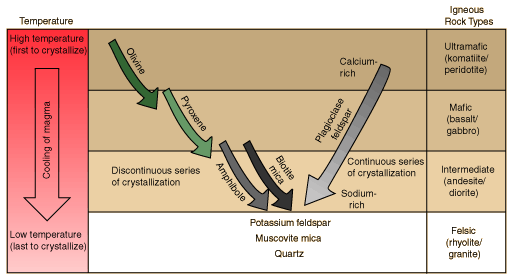
Bowen's Reaction Series

In the early part of the 20th century, N. L. Bowen carried out experiments to characterize the process of crystallization of igneous rocks from magma. The illustration below is patterned after Lutgens and Tarbuck's perspective of that reaction series.
Image

http://hyperphysics.phy-astr.gsu.edu/hb ... en.html#c1
On the Windhexe: ''An engineer could not have invented this,'' Winsness says. ''As an engineer, you don't try anything that's theoretically impossible.''

Chromium6
Posts: 537
Joined: Mon Nov 07, 2011 5:48 pm

Re: Hydrocarbons in the Deep Earth?

Unread post by Chromium6 » Sat Jun 01, 2013 11:59 am

Some more coverage of hydrocarbon formation from below:

---------------------------------------
Mineralogical Magazine

http://www.minersoc.org

Dolomitization of serpentinized harzburgite from the Atlantis Massif

FRIEDER KLEIN

Woods Hole Oceanographic Institution, ( fklein@whoi.edu )

Ophicarbonate breccias consisting of fragments of serpentinized peridotite and carbonate cement have been reported from outcrops at the Atlantis Massif, MAR 1 . While the carbonate cement precipitates due to mixing of high - pH, Ca - rich serpentinization fluids with seawater, the direct replacement of serpentinite by dolomite is more difficult to explain. Here, I report on observations made in a dolomite - altered, strongly serpentinized, partly steatitized harzburgite, from the IODP Leg 304, Hole 1309B at the Atlantis Massif. Dolomite appears in mesh and hourglass texture of completely serpentinized olivine adjacent to a talc - tremolite altered shear zone. The dolomite in these samples is surrounded by a zone of serpentine (Mg# 98), and magnetite, which traces the former (sub-) grain boundaries of olivine. Orthopyroxene is partly serpentinized to bastite, which subsequently underwent partial steatitization but not dolomitization. Both clinopyroxene and Cr-spinel are unaltered. Dolomite in serpentinite can form by conductive heating of seawater 2; however, in samples from Hole 1309B petrographic observations and microprobe analyses suggest a direct replacement of brucite and serpentine by dolomite. Phase relations in the system MgO-CaO-SiO2 -H2O-CO2 indicate that brucite is the first mineral being replaced by dolomite at relatively low CO2 , aq actvities, while dolomitization of serpentine and talc requires higher CO2, aq activities. However, it remains to be resolved whether the CO2 is of magmatic or of seawater origin. The Mg needed for the formation of dolomite is likely contributed by brucite and/or serpentine themselves, whereas Ca may have been transported from the adjacent talc - tremolite shear zone. Alternatively, the Ca may have been contributed by the dissolution of the Ca-Tschermaks component of partly serpentinized orthopyroxene. This pilot study indicates that serpentine and brucite can act as a sink for CO2 in the oceanic lithosphere, in particular where seawater and/or magmatic fluids interact with hybrid mafic/ultramafic lithologies.

[1 ] Kelley, D.S. et al. (2005 ) Science 307 , 1428 – 1434 . [ 2 ] Eickmann, B. et al. (2009) Chemical Geology 268 (1-2 ) 97 – 106

---------------------------------

Hydrocarbons and oxidized organic compounds in hydrothermal fluids from Rainbow and Lost City ultramafic-hosted vents


http://archimer.ifremer.fr/doc/00067/17828/15576.pdf

Hydrocarbons in the oceanic lithosphere

Carbon geochemistry of serpentinites at Lost City


http://www.lostcity.washington.edu/file ... n.2008.pdf

Image

-------------------------------

Might have bearing on the EU perspective:

http://www.open.ac.uk/personalpages/s.p ... 117020.jpg

Impact-generated hydrothermal systems on Earth and Mars

http://oro.open.ac.uk/34513/1/Osinski%2 ... 202012.pdf
On the Windhexe: ''An engineer could not have invented this,'' Winsness says. ''As an engineer, you don't try anything that's theoretically impossible.''

Chromium6
Posts: 537
Joined: Mon Nov 07, 2011 5:48 pm

Re: Hydrocarbons in the Deep Earth?

Unread post by Chromium6 » Sat Jun 01, 2013 12:28 pm

Another article that appears to hedge the biotic/abiotic angle:


The GC/MS of the n-alkanes shows a decrease in intensity with increasing carbon number, which seems to be a characteristic of abiotic synthesis . Recently, an abiogenic hydrocarbon production by FTT at Lost City hydrothermal field has been proposed wherever warm ultramafic rocks are in contact with water However, as discussed for the Suiyo Seamount, Izu-Bonin Arc, Pacific Ocean hydrothermal systems, it is difficult to differentiate biotic/abiotic sources. An experimental analysis of the isotopic fractionation of the stable carbon-13 and carbon-12 elements in the organic compounds detected in the Ashadze and Logatchev samples would, as it is widely thought, indicate if these organic compounds derive from microbial decomposition or from an abiotic synthesis. However, it has been demonstrated in laboratory experiments conducted at 250 °C and 350 bar, that organic products, synthesized abiotically in FTT reactions, are depleted in 13C to a degree typically ascribed to biological processes.

These experiments indicate that the analysis of the carbon isotopic fractionation is an ineffective diagnostic to distinguish between abiotic and biotic origin of organic compounds. Consequently, we will not proceed to the carbon isotopic analysis of the rocks and we do not conclude yet in a biotic or abiotic origin for the identified n-alkanes.

4. Conclusions

This preliminary analysis of the organic composition of two peridotite rock samples dredged on the ocean floor of the Logatchev and Ashadze hydrothermal sites on the Mid-Atlantic Ridge allows the identification of amino acids and long-chain n-alkanes. Many peaks of the amino acid gas chromatograms remain unidentified. Further analyses need to be made with non terrestrial amino acids as references. Signals of abiotically formed organic compounds may be present with negligible intensity compared to the intensities of the identified biotical signals. Consequently, we conclude in a biotic origin for the identified amino acids but we do not exclude an abiotic origin for some amino acids which correspond to the not yet identified peaks. Especially because it is difficult to conclude anything about a biotic/abiotic origin for the n-alkanes, since carbon isotopic fractionation is inefficient in distinguishing these sources. It would be more appropriate to analyze samples which are drilled far beneath the ocean floor and which would be less exposed to biological contamination. That could be one goal of a next IODP (Integrated Ocean Drilling Program) cruise.

http://www.ncbi.nlm.nih.gov/pmc/articles/PMC2738907/
On the Windhexe: ''An engineer could not have invented this,'' Winsness says. ''As an engineer, you don't try anything that's theoretically impossible.''

seasmith
Posts: 2815
Joined: Thu Mar 27, 2008 6:59 pm

Re: Hydrocarbons in the Deep Earth?

Unread post by seasmith » Sun Jun 02, 2013 11:27 am

by Chromium6 » Sat Jun 01,

“ “ …because it is difficult to conclude anything about a biotic/abiotic origin for the n-alkanes, since carbon isotopic fractionation is inefficient in distinguishing these sources.”

Using a purely organic hematomanalogy (for the adherents of biotic only oil),
i would suggest that some abiotic component is always present, in any vein of oil; being the ‘plasma’ fraction of the whole-fluid hydrocarbon reservoir.

Chromium6
Posts: 537
Joined: Mon Nov 07, 2011 5:48 pm

Re: Hydrocarbons in the Deep Earth?

Unread post by Chromium6 » Mon Jun 03, 2013 8:33 pm

seasmith wrote:
by Chromium6 » Sat Jun 01,

“ “ …because it is difficult to conclude anything about a biotic/abiotic origin for the n-alkanes, since carbon isotopic fractionation is inefficient in distinguishing these sources.”

Using a purely organic hematomanalogy (for the adherents of biotic only oil),
i would suggest that some abiotic component is always present, in any vein of oil; being the ‘plasma’ fraction of the whole-fluid hydrocarbon reservoir.
Nice analogy seasmith... :)


Image

History of Atmospheric CO2 through geological time (past 550 million years: from Berner, Science, 1997). The parameter RCO2 is defined as the ratio of the mass of CO2 in the atmosphere at some time in the past to that at present (with a pre-industrial value of 300 parts per million). The heavier line joining small squares represents the best estimate of past atmospheric CO2 levels based on geochemical modeling and updated to have the effect of land plants on weathering introduced 380 to 350 million years ago. The shaded area encloses the approximate range of error of the modeling based on sensitivity analysis. Vertical bars represent independent estimates of CO2 level based on the study of ancient soils.
Carbon Cycling, Plate Tectonics and Organic Matter Burial

Most scientists agree that carbon dioxide has decreased over the last 200 million years because of speeding up of the passage of carbon atoms from their volcanic sources into sediments. As we learned in the last section, to lower the CO2 content one needs fresh rocks to provide calcium, and it also helps to bury organic matter.

Fresh rocks are provided through plate collisions and mountain building, that is, uplift of land and a drop in sea level. On the whole, there has been a trend to make more mountains during the last 100 million years, and especially since the last 40 million years. This is seen in the strontium isotope content of marine carbonates. The type of strontium derived from igneous rocks on land has increased relative to the type of strontium from other sources.

Organic matter is buried in swamps (plant remains turn into coal) and in continental margins (marine algal remains become hydrocarbons). The climate cooled as the planet acquired mountain ranges (like the Himalayas) and as sea level dropped. Trade winds became more vigorous. Coastal upwelling of nutrients in coastal waters increased. Thus, more organic matter was buried along the coasts of continents. Also, an increase in the amount of mud from the rising mountains helped to bury the organic matter.

As time went on carbon dioxide was more readily turned into sedimentary carbon and the planet cooled some more. Methane hydrate could have formed on the sea floor, trapping methane and denying another source of carbon to the ocean-atmosphere system. (The exception might perhaps have been during sporadic release of this methane, followed by strange jumps in climate.)

Carbon Cycle and Computer Models

So many processes have to be considered in the carbon cycle that it is extremely difficult to keep them in mind, and impossible to calculate without building a computer model to simulate them. Scientists interested in the carbon cycle have built a number of such models over the years. Such models can have between 50 and 100 interacting equations describing all the different processes of the carbon cycle that are relevant to the problem of how carbon dioxide changes through geologic time.

To what extent should the answers generated from such models be trusted? All one can say is this: Models are the best we can do, everything else is ballpark back-of the envelope stuff. This means we should use models to educate ourselves about possibilities, realizing that their output produces probabilities not measurements.
http://earthguide.ucsd.edu/virtualmuseu ... 07_1.shtml

----------
More coverage of Oil Shale in the Green River Formation and elsewhere.

Is an EU lithology/stratigraphy possible?

http://pubs.usgs.gov/sir/2005/5294/pdf/sir5294_508.pdf
http://en.wikipedia.org/wiki/Oil_shale_geology
On the Windhexe: ''An engineer could not have invented this,'' Winsness says. ''As an engineer, you don't try anything that's theoretically impossible.''

karanbansal342
Posts: 6
Joined: Mon Nov 05, 2012 11:25 pm

Re: Hydrocarbons in the Deep Earth?

Unread post by karanbansal342 » Tue Jun 04, 2013 11:46 pm

I am preparing the Giant mailing list of followers of abiotic origin of petroleum. anyone beleeive in abiotic theory can send me a mail at sureshbansal342@gmail.com

regs
suresh

Chromium6
Posts: 537
Joined: Mon Nov 07, 2011 5:48 pm

Re: Hydrocarbons in the Deep Earth?

Unread post by Chromium6 » Wed Jun 05, 2013 6:19 pm

Found this on Gilsonite which is only found in the Green River Formation and Iran:

----------

What is Gilsonite?

Gilsonite, or North American Asphaltum is a natural, resinous hydrocarbon found in the Uintah Basin in northeastern Utah. This natural asphalt is similar to a hard petroleum asphalt and is often called a natural asphalt, asphaltite, uintaite, or asphaltum. Gilsonite is soluble in aromatic and aliphatic solvents, as well as petroleum asphalt. Due to its unique compatibility, gilsonite is frequently used to harden softer petroleum products. Gilsonite in mass is a shiny, black substance similar in appearance to the mineral obsidian. It is brittle and can be easily crushed into a dark brown powder.

Gilsonite is found below the earth's surface in vertical veins or seams that are generally between two and six feet in width, but can be as wide as 28 feet. The veins are nearly parallel to each other and are oriented in a northwest to southeast direction. They extend many miles in length and as deep as 1500 feet. The vein will show up on the surface as a thin outcropping and gradually widen as it goes deeper. Due to the narrow mining face, Gilsonite is mined today, much like it was 50 or 100 years ago. The primary difference is that modern miners use pneumatic chipping hammers and mechanical hoists.

Gilsonite is included in a class of solid bitumens known as asphaltites. Gilsonite deposits are located in eastern Utah in the United States. They are different from other asphaltites because of their:

- high asphaltene content
- high solubility in organic solvents
- high purity and consistent properties
- high molecular weight
- high nitrogen content

Gilsonite is available in different grades categorized by softening point. Softening point is used as an approximate guide to melt viscosity and behavior in solution. The chemical differences are small between Gilsonite grades, with only subtle variations in average molecular weight and asphaltene/resin-oil ratios.

The precursor of Gilsonite is believed to be kerogen from the Green River formation deep below the Uintah Basin in eastern Utah. Mild thermal reductive degradation of this kerogen and subsequent fractionation as it was geologically squeezed to the surface are believed to be responsible for the formation of the unique deposits we mine today.

http://www.zieglerchemical.com/gilsonit.htm
Mining Gilsonite during World War II was by hand, using a six pound pick and then shoveling the ore into 200 pound sacks, which were sewn by hand. In 1949 at the Parriette Gilsonite mine near Myton, Utah, Reed Smoot McConkie set the world record for ore mined by hand. Using his pick and shovel, he mined 175 bags of ore in an 8 hour day, 950 bags in a six day week, 1925 bags in a month and 15,000 bags in one year.[5]
:!: (Now that's a real American!)

http://en.wikipedia.org/wiki/Gilsonite
On the Windhexe: ''An engineer could not have invented this,'' Winsness says. ''As an engineer, you don't try anything that's theoretically impossible.''

Chromium6
Posts: 537
Joined: Mon Nov 07, 2011 5:48 pm

Re: Hydrocarbons in the Deep Earth?

Unread post by Chromium6 » Sat Jun 08, 2013 11:49 am

More on abiotic oil formation:
--------------------------------------

http://ars.els-cdn.com/content/image/1- ... 7-gr16.jpg

Thin section photomicrograph, transmitted light — crossed polarizers, of TSR dolomite cement and solid bitumen shown in Fig. 15. Note that most of the bitumen displays round/convex surfaces toward the center of the pore, mimicking formerly liquid oil droplets that clung to the margins of this pore. This bitumen may have formed as a by-product of thermal cracking or from TSR. Saddle dolomite appears as large crystal with undulous extinction

http://www.sciencedirect.com/science/ar ... 3800001767


(a nice article)

http://journals.hil.unb.ca/journalimage ... _fig12.jpg

Figure 11. Generalized relationships between oil and gas generation, temperature, thermal maturity, and bacterial and thermochemical sulfate reduction (BSR and TSR, respectively), assuming normal geothermal gradients of 25 to 30°C/km (diagram is modified from Machel et al., 1995a). Solid arrows indicate the normal thermal regimes for BSR and TSR; hollow arrows denote extreme and geologically unusual conditions. Note that the upper part of the BSR temperature range overlaps with the lower part of the liquid oil window.
Dolomitization

65 One of the most important effects of groundwater flow on carbonate aquifers and potential reservoir rocks is pervasive replacive dolomitization, which commonly but not necessarily results in a concomitant increase in porosity and permeability. Mass balance calculations indicate that large fluid fluxes are necessary for extensive, pervasive dolomitization, because of the generally low Mg-content of natural waters. From 6,500 to 10,000 m3 of brackish to fresh groundwaters (the former containing about 10% seawater) would be required to dolomitize one cubic metre of limestone with an initial porosity of 40%, or 650 m3 of seawater, the most common Mg-rich water in nature, would be required (Land, 1985). Porosity generally increases during dolomitization because generally about two moles of calcite are replaced by one mole of dolomite, with a concomitant decrease in the molar volume by about 13%. Other reaction stoichiometries, however, may result in little porosity change or in porosity loss during dolomitization (e.g., Machel and Mountjoy, 1986). Also, continued flux of fluids supersaturated with respect to dolomite may lead to cementation of pore spaces with dolomite after complete matrix replacement, a process termed "overdolomitization "(Lucia 2000). In extreme cases, the resulting dolostones are essentially non-porous and impermeable.

66 Massive dolostones with enhanced porosity and permeability relative to their limestone precursors are common all over the world. Popular dolomitization models (Fig. 12) typically depict limestones embedded in some type of local, intermediate, or regional groundwater flow system that is invoked to pump the necessary amounts of Mg through the rocks (various articles in Purser et al., 1994; Mountjoy et al., 1997; Machel, 2004). Thereby, the distribution, texture, and geochemical composition of the dolostones are fitted to perceived or possible models, in an attempt to obtain a viable genetic interpretation. Such models span all diagenetic settings from near-surface to the metamorphic realm, as well as almost any type of hydrologic flow system and geochemical composition

(My only thought about biogenic gas above 2000m is whether the biogenic CH markers are from bacteria feeding on the CH4 abiotic gas percolating upwards?)

http://journals.hil.unb.ca/journalimage ... _fig15.jpg

http://journals.hil.unb.ca/index.php/gc ... /2707/3145

1 Exploration for hydrocarbons is, first and foremost, the search for rocks with high porosity and permeability. These two basic petrophysical properties control almost all other hydrocarbon reservoir properties. Most importantly, the higher the porosity and permeability, the higher the chances for economically viable oil and gas storage, and for high flow rates during exploitation.

2 Porosity and permeability are originally controlled by sedimentary conditions at the time of deposition, and then modified by diagenetic alteration. In rocks that have not been buried deeply and/or that are relatively young, the reservoir properties are governed largely by depositional and facies parameters, such as water energy, grain size distribution, grain packing density, sorting and rounding, reef framework, etc. Overall, however, such reservoir rocks are in a minority. Most sediments and sedimentary rocks have been buried to several hundreds or thousands of meters for millions of years, with or without subsequent uplift. Commonly, the reservoir properties of such rocks are controlled by diagenesis because, with few exceptions, the effects of diagenesis increase with burial depth and time. Hence, investigations of diagenesis are instrumental for hydrocarbon exploration and exploitation, especially in deep basins.

3 Regardless of depth, investigations of diagenesis must take into account the conditions during and right after deposition, which determine the types and amounts of primary porosity and the chemistry of the pore water that may or may not have been buried with the sediments/rocks. These conditions are encompassed by the concept of "primary aquastratigraphy", as defined further below. The focus of this article, however, is on burial diagenesis, and especially on carbonates that may act as petroleum reservoir rocks. Fortunately, many if not most of the phenomena covered herein are valid for and/or applicable to both carbonates and clastics. Moreover, carbonate diagenesis cannot be treated fully without considering other rock types because of the chemical intercommunication of all rock types via hydrologic flow.

4 This article is geared primarily to individuals, students as well as professionals, who are relatively new to carbonate diagenesis and petroleum reservoir rocks. It provides an overview of the most relevant investigative methods and provides a ‘ cookbook recipe' for investigations of diagenesis (the so-called "6 - Step Process"). The ultimate goal of this paper is to aid reservoir characterization, especially the present porosity and permeability distribution that can be used in the development of hydrocarbon reservoirs by production engineers, as well as in exploration in terms of prediction of porosity and permeability.
------------------------------------

Deep gas at Luna:

http://www.pierocasero.it/dowload/V-Str ... etting.pdf

P.192
Exploration plays

The important Luna gas fields, and its satellites, were
discovered within this complex geological setting. They
are the largest gas pools outside the Po Plain and the
Northern Adriatic. There are different producing pools,
the most important of which is by far the thermogenic
dry gas ones (Luna). Issued from an unknown, possibly
Tertiary source, situated at great depth, in excess to
5000m
(SCHLUMBERGER, 1987) the gas migrated
laterally/updip through the porous conglomerate/sandy S.
Nicola Formation to be trapped at the top of truncated
beds at the crest of the thrust fold, sealed by either the
Tortonian marls or Pliocene clays. Minor accumulations
of thermal and biogenic gas were also found in sandstone
interbeds of the Ponda marls or in lower Pliocene sandy
levels.

In the recent past an important exploration effort was
made, particularly by Agip in the deeper water belt, with
the acquisition of a large amount of seismic data and the
drilling of several wildcats. No commercial discovery is
reported. Nevertheless, one can say that this is one of the
very few areas in Italy still poorly explored and
evaluated.
On the Windhexe: ''An engineer could not have invented this,'' Winsness says. ''As an engineer, you don't try anything that's theoretically impossible.''

Chromium6
Posts: 537
Joined: Mon Nov 07, 2011 5:48 pm

Re: Hydrocarbons in the Deep Earth?

Unread post by Chromium6 » Sat Jun 08, 2013 12:22 pm

Here's a theory for "rapid" oil/gas deposits in a young earth scenario with an examination of several inconsistencies in current geological theories. Overall interesting:

http://www.answersingenesis.org/article ... gin-of-oil

Some of the interesting points could be leveraged for an "EU lithography-stratiography" after ancient EU style cataclysmic world events (i.e., collisions/pole flips/planetary interactions/Worlds in Collision/etc.).

Image
In summary, we have managed to generate an unusual set of molecules which have some characteristics of crude oil. However, in comparison with real reservoir oil, the bulk of the hydrocarbons are missing. And they are the ones most useful for human life (heating, plastics, petrol, and diesel). This part of the model, as for other parts, therefore fails the sufficiency test.
Primary migration

Assuming that oil has been produced from organic matter, it now has to leave the source rock. Five mechanisms have been suggested, but each suffers from problems. Hunt (1979, p. 207ff) lists and comments on the first four.

Surfactants. Surfactants15 have been suggested as a way of swelling the oil so that it flows naturally out of the source rock. Explaining where the surfactants came from, and where they went after the oil has left the source rock, simply replaces one problem with another two.16

Migration in water. Migration of oil in solution of water has been suggested. However, the solubilities are low, especially for molecules heavier than methane.

Migration in gas. Migration of oil in the gas phase has been suggested. However, the problem is then explaining why large volumes of oil are found independently of large volumes of gas.

Single phase movement. Oil phase migration as a single phase has also been suggested. However, source rocks have very low permeabilities (Okui, Siebert, and Matsubayashi 1998, p. 46), and the oil does not move in any of the laboratory experiments that have been set up to check this mechanism.

What Okui, Siebert, and Matsubayashi (1998) have found is not unexpected. The author was involved (Matthews et al, 1988) in experimental and mathematical modelling studies to determine how internally generated phase saturations could flow. Even within highly permeable rock, large volumes have first to be created. There would also be large quantities of oil and gas left in the source rocks if this biogenic model were correct.

Migration by diffusion. Migration by diffusion has also been suggested, but Hunt (1979) offers no comments for or against. In a young-earth scenario it certainly would not work when timescales have been reduced by around five orders of magnitude.

Perhaps the fact that these ideas have all hit unmovable barriers suggests that primary migration did not happen, though the Hedberg Conference summary said euphemistically that “migration is inefficient.”
Secondary migration

This section on secondary migration will be one of the longest. This is because there is extensive literature on the subject and it has a closer association with Flood geology. When a new oil reservoir is found, apart from asking the engineers how to get the oil out, one of the next questions will be to ask how it got there. If the petroleum geologists can understand the tracks and conduits by which the oil moved from the source rock to the reservoir, they may have a handle on where else oil from those source rocks went, and this in turn gives them a clue as to where to explore for that oil. However, as we shall see, it does not work that way.

At the end of an American Association of Petroleum Geologists conference on secondary migration (1980), the chairmen (Roberts and Cordell 1980) said that there was “honest agnosticism and confessions of ignorance” on how secondary migration occurred. Models had been based on “interpretation of factual observations sponsored and enhanced by imagination.”

One looks for enlightenment in the proceedings of an equivalent conference 10 years later (England and Fleet 1992) and finds nothing except for a reiteration of the problems of 1980. Even after a further 12 years, nothing substantive was offered at a follow-up conference.17 The suite of papers has since been published (Cubitt, England, and Larter 2004), and papers rather steered away from the identifying the conduits and tracks of the supposed migration except by oblique methods. To that extent, the studies have a questionable value.

We will first examine some slightly less general statements about secondary migration to show that it is a worldwide problem. We will then examine some of the reservoirs that have been described above.

In a desired model of secondary migration, faults appear to be conduits for migration at some times and barriers at others (Barker 1996, p. 384). There is no logic to this, other than to get the petroleum into the reservoir by a secondary migration model, and then keep it there.
Oil cracking to gas leaves bitumen. Since in west Africa (Barker 1996, p. 288ff) bitumen is found above gas reservoirs, irrespective of where the supposed source rocks were, the lighter gas should be above the heavier bitumen. We do not have that.
In the North Sea, oil has to penetrate Heather shales in a downward movement to enter the huge Brent reservoir on the basis of the assumed source rocks above the reservoir (Barnard and Bastow 1992, p. 177). The same would be true of many of the other Brent-type reservoirs, such as Statfjord (Morton et al. 1992). We don’t have a mechanism.
A catalog of other North Sea reservoirs (Alba, Gullfaks, Ekofisk, Frigg, and Fulmar) where, in spite of major commercial activity in the areas, no understanding of secondary migration has been obtained (Matthews 2004).
On the Windhexe: ''An engineer could not have invented this,'' Winsness says. ''As an engineer, you don't try anything that's theoretically impossible.''

User avatar
starbiter
Posts: 1445
Joined: Mon Mar 17, 2008 9:11 am
Location: Antelope CA
Contact:

Re: Hydrocarbons in the Deep Earth?

Unread post by starbiter » Sat Jun 08, 2013 1:12 pm

Thanks for posting the above article Cr6. It does a good job of showing the problems with existing oil theories.

The conclusion confirms my position that creationists ignore Exodus, the second book of the Torah. Amazing. I might start a new group. Creationists for Exodus.

michael
I Ching #49 The Image
Fire in the lake: the image of REVOLUTION
Thus the superior man
Sets the calender in order
And makes the seasons clear

www.EU-geology.com

http://www.michaelsteinbacher.com

Chromium6
Posts: 537
Joined: Mon Nov 07, 2011 5:48 pm

Re: Hydrocarbons in the Deep Earth?

Unread post by Chromium6 » Sun Jun 09, 2013 9:25 pm

starbiter wrote:Thanks for posting the above article Cr6. It does a good job of showing the problems with existing oil theories.

The conclusion confirms my position that creationists ignore Exodus, the second book of the Torah. Amazing. I might start a new group. Creationists for Exodus.

michael
Not a problem starbiter. Just thought that some items on their site kind of tied with your abstract:

http://www.worldsci.org/pdf/abstracts/a ... s_6299.pdf

BTW, this site is pretty good for seeing how the O&G industry does mapping for the Upstream. They do need a Geological "Framework" for exploration.
http://www.aapg.org/slide_resources/sch ... /index.cfm

Hedberg Conferences:

http://www.aapg.org/education/hedberg/past/index.cfm


How to build an EU style lithography/stratigraphy?

http://www.earth-time.org/trollart.html

-------------

Image


As promised, I’ll now explain what is meant by structural styles
This is a methodology developed in the mid 1970s
It is a 2D matrix

One axis is the tectonic setting – extension, contraction, lateral or strike-slip, or regional uplift/subsidence
The second axis is the depth of faulting – do faults offset basement rocks (basement involved) or do they detach within the sedimentary section?

So what is the value of this matrix?
Historically we know of many types of traps – probably more than 40 (e.g.) high-side traps on rotated fault blocks, anticline with 4-way dip closure
This matrix gives me 8 “pigeon-holes”
There is a limited number of trap types associated with each
Thus if I know I am working in an area characterized by extension and the faults offset basement, I can be on the lookout for perhaps 8 types of traps instead of 40+ trap types
It is simply a tool to help me focus on the trap types that I should expect to see


-------------


Image

Both examples here are for basins under extension
On the left, we have basement involved faults - they offset basement (red)
One type of trap I’d be looking for in this case would be closures along the high side of the faults
The seismic comes from the data set you will look at in the exercise
On the right, the faults are basement detached
The seismic comes from the US Gulf Coast
These types of faults are commonly called listric normal faults or slump faults
The detachment plane is in “weak” marine shales, thousands of feet above basement
Note how on the reflections above the fault curve into the fault plane – these are called “roll-over” structures
A lot of oil & gas have been produced from this type of trap in Texas, Louisiana, Mississippi and Alabama – both onshore and offshore
So this is one of a handful trap types I’d be looking for if I know I am in the extension/basement detached pigeon-hole

-------------

Image

Diapirs – both salt and shale – provide large trapping potential
Here the magenta ‘blobs’ are intended to represent salt
In the upper right, there are traps above the salt on the high side of normal faults
The more significant traps are along the flanks of the salt dome where reservoir rocks dip into the salt body
Salt has extremely low permeability – fluids do not flow through them even on a geologic time scale
Oil & gas that get into the sands migrate updip; if there is a top seal, a large to giant field can form
In the lower left the salt has formed a ledge/sill/canopy
We can drill through 100s to 1000s of feet of salt and tap into super giant fields
This is the big play in the deep Gulf of Mexico
The challenge here is to image the sediments below the salt, which is very difficult since the salt body severely distorts the seismic ray paths

-------------

Image

Once we have an interpretation, we should ask “is the interpretation admissible – is the implied deformation reasonable?”
The example comes from a fold & thrust belt (highly compressive) environment
The top figure is the interpretation of the present day structuring
This example is rather old – probably in the mid 1980s
At that time, we had software that could only restore 2D cross-sections – now we have 3D restoration software
As we go down through the images, we are seeing the implied structuring back through time
The lowest image is a 2D restoration before the compression began
There are several “gaps” in the layers and a couple of overlaps
That indicates potential problems with the interpretation (we’ll ignore errors due to not working in 3D)
For example, there is a gap on the far left of the restored cross-section
This indicates that either the fault plane in the present-day interpretation is not at the correct angle or the way the layers curve into the fault is not correct.
If we plan to drill the “left” structure, this could mean either more or less oil.
Here is a KEY – if we would still drill the well given the uncertainty in the oil volume, we would not do more refinement of the interpretation
However, if we thought there would not be enough oil in the “left” structure to make a profit if the fault was (say) 5 degrees steeper; then we would test the likelihood that the fault is that steep
That means reinterpreting the fault (making it steeper), doing the restoration, and seeing if the gap is much smaller (interpretation possible closer to the truth) or much larger (less likely to be true)
Work that impacts a business decision is carried out; work that will not significantly change a business decision will not be done – makes dollars & cents?
On the Windhexe: ''An engineer could not have invented this,'' Winsness says. ''As an engineer, you don't try anything that's theoretically impossible.''

User avatar
starbiter
Posts: 1445
Joined: Mon Mar 17, 2008 9:11 am
Location: Antelope CA
Contact:

Re: Hydrocarbons in the Deep Earth?

Unread post by starbiter » Mon Jun 10, 2013 8:42 am

Interesting material Cr6.

The salt and shale domes are thought provoking. My Worlds in Collision model would have saltwater basins evaporating, leaving behind plugs of salt over oil that was deposited from above. Shale could be layers of clay from above [comets have clay in their comas] that was concentrated by equatorial sloshing.

http://www.nasa.gov/mission_pages/deepi ... 90705.html

"These solid ingredients include many standard comet components, such as silicates, or sand. And like any good recipe, there are also surprise ingredients, such as clay and chemicals in seashells called carbonates. These compounds were unexpected because they are thought to require liquid water to form."

me again,

Dr Velikovsky proposed earthquakes large enough to level every city on the planet during these events. This might explain all of the faulting in the layers of sediment Your charts show. Especially if the sediments were fresh and soft.

It would be helpful if petroleum experts considered a catastrophic scenario, as described in WiC. If oil flowed down rivers into lakes it might be possible to find extra oil and gas by going up or down stream.

The Covenant Field seems like a perfect example. I believe it was Anaconda who claimed many oil deposits in Asia are similar.

http://www.searchanddiscovery.com/docum ... 70chidsey/

Cores from the Navajo Sandstone display a variety of eolian lithofacies (dune, interdune, lake/playa, fluvial/wadi), fracturing, and minor faults which, in combina�tion, create reservoir heterogeneity. Res�ervoir sandstone is 97% frosted quartz grains (bimodal grain size), with some quartz overgrowths and illite. The net reservoir thickness is 424 ft (129 m) over a 960 acres (390 ha) area. Porosity averages 12%; permeability is ≤100 mD. The drive mechanism is a strong water drive; water saturation is 38%. A thorough understanding of all the components that created Covenant field will determine whether it is a harbinger of additional, large oil discoveries in this vast, under-explored region.

michael
I Ching #49 The Image
Fire in the lake: the image of REVOLUTION
Thus the superior man
Sets the calender in order
And makes the seasons clear

www.EU-geology.com

http://www.michaelsteinbacher.com

Chromium6
Posts: 537
Joined: Mon Nov 07, 2011 5:48 pm

Re: Hydrocarbons in the Deep Earth?

Unread post by Chromium6 » Mon Jun 24, 2013 9:32 pm

Coverage of current gas deposits:

---------
Israel approves export of 40 percent of its gas
Associated PressBy MAX J. ROSENTHAL | Associated Press – Sun, Jun 23, 2013
JERUSALEM (AP) — The Israeli Cabinet on Sunday approved exporting 40 percent of Israel's newfound natural gas reserves, keeping a larger amount for local consumption than originally expected.

Prime Minister Benjamin Netanyahu told his Cabinet the decision struck a balance between domestic needs and the concerns of the exploration companies that will drill for gas underneath the Mediterranean Sea.

"It ensures the needs of the citizens of the state of Israel, both by filling the state coffers with considerable funds from exports and by supplying the local market with cheap energy," Netanyahu said.

Last year, an advisory panel proposed exporting just over half of the country's gas, sparking protests by Israelis who said the country should keep most of its reserves to reduce energy prices at home.
Israel began pumping gas from the large Tamar field off its coast earlier this year. It is expected to begin exporting when a second, larger field goes online in 2016.
The consortium that has developed the fields, led by U.S. company Noble Energy, did not immediately comment on Sunday's decision. In the past, it has said it would have preferred the larger export levels.

Hebrew University professor Eytan Sheshinski, an expert on energy policy, said that despite the export numbers, he expected the energy companies to be satisfied with Sunday's decision.

"When the dust settles, they can live with this decision, and I think it didn't cross their red line," said Sheshinski, who headed a committee that gave policy recommendations to the Israeli government in 2010 on taxing natural gas exports.

Sunday's decision reserved 540 billion cubic meters of natural gas for the domestic market. Netanyahu said that amount would supply Israelis with natural gas for at least 25 years, a figure that Sheshinski said was largely accurate.

Earlier in the month, Environment Minister Amir Peretz said he wanted at least 600 billion cubic meters set aside for local use.

Last week, Netanyahu said that Israel seeks to earn $60 billion over the next two decades from the exports.
http://news.yahoo.com/israel-approves-e ... 22171.html

http://intellihub.com/2013/05/07/israel ... othschild/
Last edited by Chromium6 on Mon Jun 24, 2013 10:19 pm, edited 2 times in total.
On the Windhexe: ''An engineer could not have invented this,'' Winsness says. ''As an engineer, you don't try anything that's theoretically impossible.''

Chromium6
Posts: 537
Joined: Mon Nov 07, 2011 5:48 pm

Re: Hydrocarbons in the Deep Earth?

Unread post by Chromium6 » Mon Jun 24, 2013 9:35 pm

Natural Gas Futures Decline on Bigger-Than-Forecast Supply Gain
By Naureen S. Malik - 2013-06-20T19:40:39Z
Natural gas futures fell in New York for the first time in four days after U.S. stockpiles rose more than forecast.

Gas dropped 2.2 percent as the Energy Information Administration said inventories expanded by 91 billion cubic feet in the week ended June 14 to 2.438 trillion cubic feet. Analyst estimates compiled by Bloomberg showed an expected gain of 89 billion. Supply increases have exceeded the five-year average for three consecutive weeks as mild weather reduced demand from power plants.

“We are certainly getting outsized injections at this point and that is a function of a lack of demand,” said Stephen Schork, president of Schork Group Inc., a consulting group in Villanova, Pennsylvania. “As we go into the hottest part of the summer, people in New York, Chicago and Boston are finally going to turn on their air conditioners next week. You are going to see injections over the next two months start to pull back.”

Natural gas for July delivery fell 8.6 cents to settle $3.877 per million British thermal units on the New York Mercantile Exchange. Trading was 2.8 percent below the 100-day average at 2:40 p.m. Gas is up 16 percent this year.

The discount of July to October futures widened 0.6 cent from yesterday to 3.1 cents.
Gas Options

July $3.85 puts were the most active options in electronic trading. They were 1.2 cents higher at 2.6 cents per million Btu on volume of 1,391 at 3:08 p.m. Puts accounted for 55 percent of trading volume. Implied volatility for at-the-money options expiring in August was 28.74 percent at 3 p.m., compared with 29.59 percent yesterday.

The stockpile increase was bigger than the five-year average gain for the week of 80 billion cubic feet, department data show. A deficit to the five-year average narrowed to 1.9 percent from 2.4 percent the previous week. Supplies were 18.7 percent below year-earlier inventories, down from 20 percent in last week’s report.

“We are now seeing that build in cooling demand, and that will likely curb the industry’s restocking ability,” said Teri Viswanath, director of commodities strategy at BNP Paribas SA in New York.

Gas futures had rebounded since dropping to a three-month low last week on the outlook for hotter weather that would boost demand for the power-plant fuel to run air conditioners.
Hotter Weather

Temperatures across most of the lower 48 states will be above normal from June 25 through July 14, according to MDA Weather Services in Gaithersburg, Maryland. The high in Boston on June 24 may be 90 degrees Fahrenheit (32 Celsius), 11 higher than usual, and Houston may reach 99 degrees on July 2, 8 above normal, said AccuWeather Inc. in State College, Pennsylvania.

Electricity generators, the largest consumers of U.S. gas, will account for 32 percent of demand in 2013, according to the EIA.

U.S. gas output will rise to an all-time high for the sixth straight year as new wells come online at shale formations, such as the Marcellus in the Northeast. Marketed gas production will average a record 70.01 billion cubic feet a day this year, up 1.2 percent from 69.18 billion in 2012, the EIA said June 11 in its monthly Short-Term Energy Outlook.

“After stabilizing in 2013, gas output will rise strongly” from 2014 through 2018 as higher prices spur drilling and expanded infrastructure allows more shale supplies to reach the market, the International Energy Agency said in its Medium-Term Market Report, released today.
http://www.bloomberg.com/news/2013-06-2 ... trade.html

----------
Wednesday, February 22, 2012

PA Joins 1 Trillion Cubic Feet Club
In 2011, Pennsylvania produces 1.042 trillion cubic feet of gas, making the Commonwealth one of the nation's biggest and most important gas producing states. Pennsylvania gas production has increased more than five-fold since 2006.

In the last 6 months of 2011, Pennsylvania produced 607 billion cubic feet of gas, a significant increase over the 435 billion cubic feet of gas produced in the first 6 months of 2011.

Production in 2012 will likely increase again, despite a slow down in drilling of new wells in dry gas areas, because more wells already drilled will be connected to pipelines and more gas will flow to market. But the reduction of gas rigs in Pennsylvania by companies like Chesapeake Energy and Talisman will have an impact this year. The 2012 production will be lower than it would have been had gas prices remained at $4 or higher for a thousand cubic feet.

How long can gas prices remain below $4? Since few people even 12 months ago forecast gas prices falling to $2.50, answering that question requires humility and heads into the unknown. External factors like weather and possible shocks to the US economy from a war with Iran or a deep European recession impact gas prices. I would only say prices are going to rise and not in the distant future.
More clear is that Pennsylvania production gains are a major reason that gas prices have crashed, and why gas and electricity consumers around the country have seen substantial savings in the last 24 months.
http://johnhanger.blogspot.com/2012/02/ ... -club.html
On the Windhexe: ''An engineer could not have invented this,'' Winsness says. ''As an engineer, you don't try anything that's theoretically impossible.''

Chromium6
Posts: 537
Joined: Mon Nov 07, 2011 5:48 pm

Re: Hydrocarbons in the Deep Earth?

Unread post by Chromium6 » Mon Jun 24, 2013 9:51 pm

1,000 trillion cubic feet of offshore shale gas? “Don’t believe the figures,” says geologist

19 Apr 2012, 17:00
Ros Donald

Reports emerged yesterday that the UK might have around 1,000 trillion cubic feet of offshore shale gas, a figure the Times and Wall Street Journal are attributing to the British Geological Survey (BGS). But when we asked BGS, it told us it doesn't recognise the estimate, or think that much gas will be recoverable. So what's going on?

The Times wrote:

"Yesterday, the British Geological Survey released estimates of Britain's offshore shale gas reserves, which could exceed one trillion cubic feet, more than five times the estimated onshore deposits, it said. This would catapult the UK into the top ranks of worldwide producers of shale gas."

In 2011, BGS estimated the total onshore shale gas resource in the UK at 144 billion cubic metres. It is currently in the process of coming up with a new estimation for onshore resource, but we didn't know anything about a new offshore estimate. So it seemed a bit out of character for BGS to start announcing offshore reserves of 1,000 trillion cubic feet off UK shores.

On investigation, it appears this figure stems from a Reuters report on Tuesday: Exclusive: UK has vast shale gas reserves, geologists say. Reuters quotes a BGS geologist, Nigel Smith, saying:

"'There will be a lot more offshore shale gas and oil resources than onshore,' [...] UK offshore reserves could be five to 10 times as high as onshore[...]."

Smith made this statement to the UK's energy and climate change committee in February 2011 during an investigation into shale gas.

But when we asked him whether he'd ever said the UK's offshore reserves equalled 1,000 trillion cubic feet, Smith told us:

"Don't believe the figures!"

Shale gas company Cuadrilla last year estimated the UK's onshore reserves at 200 trillion cubic feet. Says Smith:

"What [the reporter] has done, I think, is take Cuadrilla's 200 [trillion cubic feet] resource and multiplied by five."

The Cuadrilla figure is not uncontroversial either - an earlier article describes BGS as "sceptical" about it. Reuters seemed to realise this a bit late in the day, as a later version of their report adds the caveat:

"[S]ome experts doubt preliminary onshore reserve figures by private companies."

Smith advises further caution, saying there's big difference between theoretical reserves and the amount of shale gas ultimately recoverable:

"We would need to work out the areas of different aged source rocks offshore and plug in some gas contents and thicknesses to come up with a ball-park figure of this theoretical resource. At current technology onshore US only 10% of the resource is actually produced."

Reuters did mention this, but the Times and WSJ miss that bit out.

He added that although there are arguments in favour of UK concentrating on offshore reserves - including energy security and minimising potential harm to the public - the day when they are exploitable is still far off. The UK will have to pioneer offshore shale gas drilling because the US, the trailblazer in unconventional gas, has not needed to look further than its onshore reserves.

It is possible, of course, that there is a significant amount of shale gas offshore. A column in the Economist suggests the UK government has pulled together its own data that also suggests reserves could be significant. And Reuters also claims that energy companies are getting excited about larger than imagined shale gas reserves:

"Geologists at [...] leading energy companies spoke on condition of anonymity due to the sensitive nature of the dramatically higher estimates, but a consensus of optimism about potential European reserves has grown in the hard-headed commercial sector."

But these estimates don't come from the BGS.

There's another point that the UK will have to take into account if it wants to meet its emissions targets. A column by pro-shale gas pundit Matt Ridley in the Times illustrates the difficulty the UK faces in further cutting emissions if it goes for unconventional gas wholesale. Ridley says:

"[S]hale gas has already cut carbon emissions in a way that wind, biomass and solar power have failed to do".

He cites a 7 per cent drop in US emissions in 2009 as "caused largely by a switch to shale gas". There's an obvious problems with his argument: the UK already derives the majority of its electricity from gas, while shale gas in the US has displaced coal-fired plants - as we explain here. If, indeed, shale gas were to displace UK renewables, that won't help us meet our emissions targets.
http://www.carbonbrief.org/blog/2012/04 ... -shale-gas

-----------
Repsol Finds 1 Trillion Cubic Feet of Gas in Bolivia's Rio Grande Region
By Joao Lima - 2010-08-09T16:40:59Z

Repsol YPF SA, Spain’s biggest oil company, found a new deposit in Bolivia’s Rio Grande area that it estimates has 1 trillion cubic feet of natural gas.

The discovery was made in the RGD 22 well and production tests indicate a flow of 6 million cubic feet of gas a day, Repsol said. The Madrid-based company made the discovery as a partner in the YPFB Andina venture, in which it owns a 49 percent stake while the Bolivian government holds 50 percent. This field has been in production since 1968, Repsol said.

“As the Rio Grande area already has the necessary infrastructure, these resources can be put into production in a short period of time,” Repsol said in an e-mailed statement. “With this discovery, YPFB Andina consolidates its position as the largest hydrocarbon producer in Bolivia.”

The Spanish company is investing in exploration in Brazil’s offshore Santos Basin, Bolivia and elsewhere to increase reserves and output, while trying to reduce exposure to mature fields in Argentina. Bolivia has the second-biggest natural-gas reserves in South America.

Repsol added 1.9 percent to close at 18.96 euros in Madrid. The stock has climbed 1.3 percent this year, valuing the company at 23.1 billion euros ($30.6 billion).

Repsol on April 29 said it forecasts annual production growth of as much as 4 percent through 2014 as projects in Brazil and Peru come on stream. The company plans to invest 28.5 billion euros in the period. It will develop projects such as the Guara and Piracuca fields in Brazil, Kinteroni in Peru, Cardon IV in Venezuela and Margarita-Huacaya in Bolivia.

To contact the reporter on this story: Joao Lima in Lisbon at jlima1@bloomberg.net
http://www.bloomberg.com/news/2010-08-0 ... egion.html


-----------

Petrolia: Estimates of 1 Tcf of Wet Natural Gas in Bourque
by Petrolia Inc.

Press Release
Wednesday, April 10, 2013

Pétrolia disclosed the results of a resource evaluation carried out by Sproule Associates Limited (Sproule) which estimates more than 1 trillion cubic feet (Tcf) or 1 thousand billion cubic feet of volume initially-in-place of wet natural gas of four prospects within the Bourque project. This project is located in forested Crown land, where Petrolia drilled two wells in 2012. This independent evaluation, was carried out at Petrolia's request, for the purpose of evaluating the Company's resource volumes according to the Canadian Oil and Gas Evaluation Handbook (COGEH) reserve and resource definitions that are consistent with the standards of National Instrument 51-101.

During drilling and testing operations, wet natural gas and traces of light oil have been recovered. This wet natural gas is rich in liquid petroleum gases (propane and butane), condensate (pentane, hexane, etc.). Log evaluation indicates the presence of a reservoir with vuggy type porosity associated with open fracture networks (Jan. 30 press release). Analyses of the tests show a conventional low permeability carbonate reservoir (tight gas carbonate reservoir). Carbonates of the Forillon Formation, which extend over large areas, and located close to major faults, such as the North West Arm Fault, constitute for Petrolia a promising exploration play in the Gaspé Peninsula.

To carry out its estimation, Sproule conducted an analysis of the petrophysical properties measured in both wells, and reviewed the interpretation of Petrolia's 3D seismic data. Sproule also generated various 3D seismic attribute volumes in order to identify possible zones of hydrothermal alteration "prospective" for porosity development. The territory between wells Bourque 1 and Bourque 2 has not, for the time being, been considered in the resource estimate carried out by Sproule.

Resources of four prospects in the low permeability carbonates of the Forillon Formation have been evaluated. Results for each of these prospects are shown in the following table. The report indicates that the data do not allow an estimation of the liquid hydrocarbon volumes (condensate and light oil) whose commercial value is higher than that of dry gas.

Petrolia is presently in the process of preparing a production test program for these two wells, based on Sproule's recommendations. The objective of these production tests will be to quantify the production characteristics of the Forillon Formation and better delineate the in-place resources and potential recoverable volumes.
http://www.rigzone.com/news/oil_gas/a/1 ... in_Bourque

-------------

And of course-- known since before the attack in 2006:


Energy minister: Lebanon has over 30 trillion cubic feet offshore gas

Friday, 31 May 2013

Lebanon has selected 46 international oil companies to bid to explore for gas off its coast, where survey ships have been assessing prospects after discoveries in waters off neighboring Israel and Cyprus. (File photo: Reuters)


Laila Bassam, Reuters

Offshore seismic surveys suggest Lebanon has at least 30 trillion cubic feet in just a small fraction of its Mediterranean waters, Energy Minister Gebran Bassil said.

Lebanon has selected 46 international oil companies to bid to explore for gas off its coast, where survey ships have been assessing prospects after discoveries in waters off neighboring Israel and Cyprus.

“The numbers are likely to increase ... but the latest is 30trillion cubic feet in only 10 percent of Lebanon’s waters,” Bassil told Reuters on board a vessel carrying journalist to one of the survey ships.

He said nearly three quarters of more than 22,000 square km of sea waters had been surveyed, but did not give a figure for the overall potential reserves.

“We’re talking about big commercial quantities,” he said.

Neil Hodgson of survey firm Spectrum said he believed one southern area of around 3,000 square km might hold between 17and 50 trillion cubic feet of gas, while total deep-water reserves could be up to 80 trillion cubic feet.

“In the northern area, if we find the same sort of prospectively, we should see another 20 or 30 trillion cubic feet of gas,” he told Reuters.

“So in total, the resources should be in the order of 40 to80 trillion cubic feet of gas offshore Lebanon in that deep-water area.”

Bassil said the deadline for companies to submit bids for exploration in the 10 offshore blocs was in October and first contracts should be signed in February.

The minister, acting in a caretaker capacity since the resignation of Prime Minister Najib Mikati in late March, has sought to play down concerns that the political deadlock preventing formation of a new cabinet will delay any gas deals.

Any gas exploration contracts would need cabinet endorsement, but Prime Minister designate Tammam Salam has yet to form his government.

“This will need to be done in February 2014 and I don’t think Lebanon will remain without a government (for) all that time,” Bassil said.

Lebanon selected 46 companies last month to bid for gas exploration, 12 of them as operators and 34 as non-operators.

http://english.alarabiya.net/en/busines ... -gas-.html
On the Windhexe: ''An engineer could not have invented this,'' Winsness says. ''As an engineer, you don't try anything that's theoretically impossible.''

Locked

Who is online

Users browsing this forum: No registered users and 28 guests