Cave 'breathing' regulates growth of stalactites
STALACTITES are formed by the drip, drip of water, right? Not entirely. The way caves "breathe" is the true controller, a finding which pours doubt on ancient climate records derived from these structures.
Philip Froelich of Florida State University in Tallahassee and colleagues recorded air circulation in the Hollow Ridge cave near Marianna by measuring airborne radon, a naturally occurring radioactive gas. They found that levels were lowest in the winter, when cold, moist air at higher pressure rushes into the cave and flushes out stale, radon-rich air (Earth and Planetary Science Letters, DOI: 10.1016/j.epsl.2009.11.010).
The team suggest that stagnant summer air is hindering the precipitation of calcium carbonate from groundwater. That's because carbon dioxide is given off during the reaction, and if C02 levels in the surrounding air get too high, precipitation ceases. "If caves don't breathe they don't produce stalagmites," says Froelich.
Some records of ancient rainfall may be skewed, as estimates based on stalactite formation assume year-round mineral deposition.
http://www.newscientist.com/article/mg2 ... tites.html
Possible electrical scars on Planet Earth...
-
MattEU

- Posts: 367
- Joined: Sun Jun 29, 2008 8:00 am
- Contact:
new scientist article on Cave 'breathing' and stalactites
What are the odds? Just found this through twitter, released today!
-
nick c

- Site Admin
- Posts: 2483
- Joined: Sun Mar 16, 2008 8:12 pm
- Location: connecticut
Re: outdoor stalagmites and Death Coral
Hi MattEU,
Nice work, very interesting.
It has been suggested in the TPOD [url2=http://www.thunderbolts.info/tpod/2007/ ... averns.htm]Electric Caverns[/url2] that stalactites and stalagmites are the remains of a [url2=http://www.minresco.com/fulgurites/fulgurites.htm]fulgurite[/url2] type of formation that water then drips from or upon, after their formation.
Nick
Nice work, very interesting.
It has been suggested in the TPOD [url2=http://www.thunderbolts.info/tpod/2007/ ... averns.htm]Electric Caverns[/url2] that stalactites and stalagmites are the remains of a [url2=http://www.minresco.com/fulgurites/fulgurites.htm]fulgurite[/url2] type of formation that water then drips from or upon, after their formation.
If water dripping inside a cavern is not the only requirement for the formation of all stalagmites, then some of the mystery of outdoor locations is removed.Fulgurites, or the fused trackway of lightning bolts through refractory minerals, are common in Jenolan and in most other caverns. Could stalactites and stalagmites found therein actually be the remains of fulgurites? As we have suggested in the past, some geographical features, like rivers, may have "adopted" discharge channels after they were excavated by a plasma blast. Perhaps drops of water roll down stalactites after their formation as fulgurites?
Nick
-
MattEU
- Posts: 367
- Joined: Sun Jun 29, 2008 8:00 am
- Contact:
Re: outdoor stalagmites and Death Coral
thanks and also cheers to seasmith for his input that helped my output and also for you mentioning that article. And what an article it is, so much info and photos.
I think i must have read the article back in the day because when i visited our local famous cave, Ghar Dalam, with another EU person we discussed the issue of the strange stalagmites there. Either I did read the article or the common sense and logic of the EU Theory meant that it was a basic idea that others have or will also come to.
The shapes of the stalagmites in Ghar Dalam are a little weird and there are horizontal layers going across the floor of the cave and through the stalagmites that make no sense from a geology point of view but could perhaps be explained by the EU. We wondered if a large flow of current had transformed those certain layers that go across the whole floor and through the stalagmites. Of course we might have just been looking for mystery and it could be easily explained by normal things.
I should find my photos of them and post them but here are a couple of links to some, you can see the layers jutting out of them. http://outdoors.webshots.com/photo/2074 ... 2508kyBIYC http://www.panoramio.com/photo/2160701
It might be one of those you have got to be there things though from looking at it now
The thing with Ghar Dalam is that it has an amazing amount of smashed up fossil remains, Giant Swans to mini normally large stuff (hippopotamus, elephants). Some are fossilised, others are not and some seem to be half of each type. Also the cave has layers of pebbles, which is strange again on a limestone island. It all smells of EU to me
-
MattEU
- Posts: 367
- Joined: Sun Jun 29, 2008 8:00 am
- Contact:
man made global warming?
Man made global warming and climate change?
"Each climate regime lasted from a few hundred years to more than one thousand years, she said. In many cases, the transition from wet to dry or vice versa took less than 200 years.
"These changes are part of a global pattern of abrupt changes that were first documented in Greenland ice cores," she said. "No one had documented those changes in the Southwest before."
Does anyone know more about oxygen-18 from an EU point of view? How it may effect the water or chemicals in the stalagmites already grown? Could it be used to date catastrophes etc?
I got the quote below from Wiki about Oxygen-18
"Each climate regime lasted from a few hundred years to more than one thousand years, she said. In many cases, the transition from wet to dry or vice versa took less than 200 years.
"These changes are part of a global pattern of abrupt changes that were first documented in Greenland ice cores," she said. "No one had documented those changes in the Southwest before."
Limestone cave reveals Southwest climate change swingsThe finding is the first to document that the abrupt changes in Ice Age climate known from Greenland also occurred in the southwestern U.S., said co-author Julia E. Cole of the University of Arizona in Tucson.
"It's a new picture of the climate in the Southwest during the last Ice Age," said Cole, a UA professor of geosciences. "When it was cold in Greenland, it was wet here, and when it was warm in Greenland, it was dry here."
The researchers tapped into the natural climate archives recorded in a stalagmite from a limestone cave in southern Arizona. Stalagmites grow up from cave floors.
The stalagmite yielded an almost continuous, century-by-century climate record spanning 55,000 to 11,000 years ago. During that time ice sheets covered much of North America, and the Southwest was cooler and wetter than it is now.
Cole and her colleagues found the Southwest flip-flopped between wet and dry periods during the period studied.
Each climate regime lasted from a few hundred years to more than one thousand years, she said. In many cases, the transition from wet to dry or vice versa took less than 200 years.
"These changes are part of a global pattern of abrupt changes that were first documented in Greenland ice cores," she said. "No one had documented those changes in the Southwest before."
Scientists suggest that changes in the northern Atlantic Ocean's circulation drove the changes in Greenland's Ice Age climate, Cole said. "Those changes resulted in atmospheric changes that pushed around the Southwest's climate."
Limestone cave reveals Southwest climate change swingsA rare form of oxygen, oxygen-18, is more common in the calcium carbonate deposited during dry years. By seeing how much oxygen-18 was present in each layer, the scientists could reconstruct the region's pattern of wet and dry climate.
To assign dates to each wet and dry period, Wagner used another slice of the core for an analysis called uranium-thorium dating.
The radioactive element uranium is present in minute amounts in the water dripping onto a stalagmite. The uranium then becomes part of the formation.
Uranium decays into the element thorium at a steady and known rate, so its decay rate can be used to construct a timeline of a stalagmite's growth.
Does anyone know more about oxygen-18 from an EU point of view? How it may effect the water or chemicals in the stalagmites already grown? Could it be used to date catastrophes etc?
I got the quote below from Wiki about Oxygen-18
I find it stange that one part of science mention all these meteor and volcanic catastrophes, how the worlds climate has changed so much and then climate people seem to ignore it when it comes to dating processes. Or have i got it wrong and our atmospheric conditions dont change during "ice ages" etc or in the last 55k years?Paleoclimatology
In ice cores, mainly Arctic and Antarctic, the ratio O-18/O-16 (δ18O) can be used to determine the temperature of precipitation through time. Assuming that atmospheric circulation and elevation has not changed significantly over the poles, the temperature of ice formation can be calculated as equilibrium fractionation between phases of water is known for different temperatures.
-
MattEU
- Posts: 367
- Joined: Sun Jun 29, 2008 8:00 am
- Contact:
Abrubt climate change affects hypogenic caves also
The Cave of Bells
The previous report is about the "Cave of Bells", a living or wet cave as they describe it. It has a breeze flowing through it or coming from it, is this the same as the breathing in the other caves discussed above? The Cave of Bells also has a indoor heated swimming pool, or, as the geologist boringly describe it a lake heated from below. The report quoted before is entitled "Moisture Variability in the Southwestern U.S. Linked to Abrupt Glacial Climate Change" which has to be another nail in the coffin to man made Global Warming.
The Cave of Bells is a fragile environment.
The Giant Crystal Cave
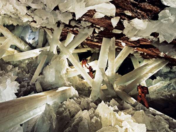
Caves (Cueva de los Cristales, Cueva de las Velas, Cueva de las Espadas?) near Naica mine (Chihuahua, Mexico)
The Cave of the Bells are perhaps as opposite to the giant crystal caves mentioned and shown in the image as you can get. The Giant Crystal Cave and the others around it are "hypogenic caves" which seems to mean they are not connected directly to the outside world. Yet it appears to show similar flip flop changes, due to Climate Change, as the Cave of Bells.
So are the changes not due directly to atmospheric Climate Change? But to the changes in the Earths natural energy, electromagnetic fields, flow of "Telluric Currents" etc. The changes in the exchange between the Earth and the Electric Universe that "Climate Change" or "Energy Change" seem to suggest. Both caves could of course be the result of Climate Change filtering down and affecting deep inside the Earth but this is an EU forum so we can discuss the possibility that they are not
Please can someone check what I have said about the caves from the reports to make sure I have got the "facts" right about the differences and similaritries of the caves and the reports.
Even if you dont read or click on any other link you need to click on this one and see the photographs and descripition of "The Deadliest place on Earth? Surviving Cueva de los Cristales - The Giant Crystal Cave". The reporter says that conditions in the The Giant Crystal Cave are
The previous report is about the "Cave of Bells", a living or wet cave as they describe it. It has a breeze flowing through it or coming from it, is this the same as the breathing in the other caves discussed above? The Cave of Bells also has a indoor heated swimming pool, or, as the geologist boringly describe it a lake heated from below. The report quoted before is entitled "Moisture Variability in the Southwestern U.S. Linked to Abrupt Glacial Climate Change" which has to be another nail in the coffin to man made Global Warming.
SANTA RITA CAVES - CAVE OF THE BELLSHodgson was first made aware of the cave in 1941 by miners working the nearby Snyder Mines who warned him that there was deadly mine gas in the cave. He found the 3-foot diameter entrance described by the miners and noticed air flowing from it. He surmised that the presence of circulating air minimized the threat of mine gas and boldly entered the cave he would come to know like the back of his hand.
CAVE OF THE BELLS – The Cave of the Bells is located in Sawmill Canyon on the
eastern slope of the Santa Rita Mountains. Lake Tunnel, one of its most notable and accessible passages, leads through a large room to a permanent lake about 250 feet below the entrance level. The air in this area of the cave is unusual in that it is warmer than the air at the entrance of the cave instead of cooler. The temperature of the water in the lake has been measured at 76 degrees Fahrenheit which indicates that the lake may be heated by sources below it.
...He called one of his discoveries the Cathedral Dome Room. In it he found some stalactites that were of a much lighter color than the others. He found that if you gently struck them, they produced a sound that was similar to that of bells. These phenomena eventually gave the cave its name, The Cave of the Bells.
The Cave of Bells is a fragile environment.
CAVE OF THE BELLSThe Cave of the Bells is a fascinating and fragile underground wilderness. Though this subterranean gallery of rock -- known for its unique and varied suite of minerals and formations -- has been thousands of years forming, it is nevertheless extremely fragile.
The Giant Crystal Cave
Caves (Cueva de los Cristales, Cueva de las Velas, Cueva de las Espadas?) near Naica mine (Chihuahua, Mexico)
The Cave of the Bells are perhaps as opposite to the giant crystal caves mentioned and shown in the image as you can get. The Giant Crystal Cave and the others around it are "hypogenic caves" which seems to mean they are not connected directly to the outside world. Yet it appears to show similar flip flop changes, due to Climate Change, as the Cave of Bells.
So are the changes not due directly to atmospheric Climate Change? But to the changes in the Earths natural energy, electromagnetic fields, flow of "Telluric Currents" etc. The changes in the exchange between the Earth and the Electric Universe that "Climate Change" or "Energy Change" seem to suggest. Both caves could of course be the result of Climate Change filtering down and affecting deep inside the Earth but this is an EU forum so we can discuss the possibility that they are not
Please can someone check what I have said about the caves from the reports to make sure I have got the "facts" right about the differences and similaritries of the caves and the reports.
Even if you dont read or click on any other link you need to click on this one and see the photographs and descripition of "The Deadliest place on Earth? Surviving Cueva de los Cristales - The Giant Crystal Cave". The reporter says that conditions in the The Giant Crystal Cave are
The caves in the photogaph and quoted below are found in Mexico and contain giant Gypsum crystals. They also seem to have been affected by the abrubt climate changes that hit this part of the globe.It's 50oC and has a humidity of 100%, less than a hundred people have been inside and it's so deadly that even with respirators and suits of ice you can only survive for 20 minutes before your body starts to fail. It’s the nearest thing to visiting another planet – it’s going deep inside our own.
Mexican megacrystals formed by climate back-and-forth (newscientist.com)WHY are these crystals so huge? The answer is ancient climate swings.
Gypsum crystals up to 11 metres long were found a decade ago in caves next to the Naica mine near Chihuahua, Mexico. Over the past 200,000 years the regional climate has swung from wet to dry, suggests water trapped in the crystal. Ground level evaporation during the dry period concentrated calcium in salty surface water flowing into the caves. The evaporation repeated as the climate switched back and forth, providing enough calcium to build such big crystals, say Paolo Garofalo of the University of Bologna, Italy, and colleagues (Earth and Planetary Science Letters, vol 289, p 560).
Giant Crystal Cave Comes to Light (nationalgeographic.com)How did the crystals reach such superheroic proportions?
In the new issue of the journal Geology, García-Ruiz reports that for millennia the crystals thrived in the cave's extremely rare and stable natural environment. Temperatures hovered consistently around a steamy 136 degrees Fahrenheit (58 degrees Celsius), and the cave was filled with mineral-rich water that drove the crystals' growth.
Modern-day mining operations exposed the natural wonder by pumping water out of the 30-by-90-foot (10-by-30-meter) cave, which was found in 2000 near the town of Delicias.
Climatic control on the growth of gigantic gypsum crystals within hypogenic caves (Naica mine, Mexico)?Climatic control on the growth of gigantic gypsum crystals within hypogenic caves (Naica mine, Mexico)?
Abstract
Three hypogenic caves within the Naica mine of Mexico (Cueva de los Cristales — CLC, Ojo de la Reina — OR, and Cueva de las Velas — CLV) host spectacular gypsum crystals up to 11 m in length. These caves are close to another shallow cave of the area (Cueva de las Espadas — CLE), with which they cover a 160 m-deep vertical section of the local drainage basin. Similar to other hypogenic caves, all these caves lack a direct connection with the land surface and should be unrelated with climate.
A record of multi-technique fluid inclusion data and pollen spectra from cave and mine gypsum indicates surprisingly that climatic changes occurring at Naica could have controlled fluid composition in these caves, and hence crystal growth. Microthermometry and LA-ICP-Mass Spectrometry of fluid inclusions indicate that the shallow, chemically peculiar, saline fluid (up to 7.7 eq. wt.%NaCl) of CLE could have formed from evaporation, during a dry and hot climatic period. The fluid of the deep caves was instead of low salinity (not, vert, similar 3.5 eq. wt.% NaCl) and chemically homogeneous, and was poorly affected by evaporation. We propose that mixing of these two fluids, generated at different depths of the Naica drainage basin, determined the stable supersaturation conditions for the gigantic gypsum crystals to grow. Fluid mixing was controlled by the hydraulic communication between CLE and the other deep caves, and must have taken place during cycles of warm-dry and fresh-wet climatic periods, which are known to have occurred in the region. Pollen grains from a 35 ka-old gypsum crystal of CLC corresponds to a fairly homogenous catchment basin made of a mixed broadleaf wet forest, which suggests precipitation during a fresh-wet climatic period and confirms our interpretation of the fluid inclusion data.
The unusual combination of geological and geochemical factors of Naica suggests that other hypogenic caves found elsewhere may not host similar crystals. However, this work shows that fluid inclusions and pollen spectra represent a useful tool for cave studies in general, and if used in future studies might be essential to unravel the mechanisms of hypogenic deposition.
-
mharratsc
- Posts: 1405
- Joined: Mon Jan 26, 2009 7:37 am
Re: outdoor stalagmites and Death Coral
I'm not a geologist, but... 
So- there seems to be some corrolation with these formations and the going from a 'wet-to-dry' environment.
In a wet environment, currents in the local strata would go from diffuse, to concentrated on paths of least resistance (heavily governed not only by actual impedance, but also affected by areas permitting best formation of EM fields). Materials would draw towards these pathways if they were aqueous suspensions, eventually 'crystallizing' in hexagonal patterns (for the most part) much as we see with all those cave formations. I would guess that those horizontally-fanned formations were probably made as water tables dropped in those caverns, by minerals that had a high flotation (trapped air/high water repulsion). They probably were 'floaters' that crystallized in sheets as the water tables in the caverns dropped incrementally over time.
As for the outdoor stuff on Malta- interestingly enough, Matt posted in one of his articles on his site that even while most of Europe was freezing, they were wearing t-shirts and shorts on Malta. Where was the extra energy coming from that was keeping it so warm there? How does one account for the high levels of lightning seen on the island? How do you explain the bizarre terrain found on Malta (cart ruts, holes in rocks, fulgurites everywhere)?
To me, it seems that Malta remains to this day a major component in the telluric-to-atmospheric bridge in the Earth-to-Sun circuit. Coupled with Malta's high humidity and windblown ocean spray, you have a very good air-to-ground conductive medium. You probably won't see as many transmutation or crystallization effects as you will in a hot, wet cavern, but you should still see some- the death coral as a case in point.
Mike H.
"I have no fear to shout out my ignorance and let the Wise correct me, for every instance of such narrows the gulf between them and me." -- Michael A. Harrington
"I have no fear to shout out my ignorance and let the Wise correct me, for every instance of such narrows the gulf between them and me." -- Michael A. Harrington
-
MattEU
- Posts: 367
- Joined: Sun Jun 29, 2008 8:00 am
- Contact:
Re: outdoor stalagmites and Death Coral
many thanks for the reply mharratsc, it all sounds good to me
Malta does seem to be a real focal point in the Earths Electric Circuit, the locals even say that the trade winds start here or that the islands start the process of powering them up!
i have been trying to find my photos of Ghar Dalam cave but i just can not find them. I was going to reply showing what might be the layers across the stalagmites and the whole cave floor. Thankfully Malta aint to large (car rentals here dont even have a mileage per day limit : ) so I guess i will visit them again and then i can hopefully post some photos showing this.
-
tolenio

- Posts: 244
- Joined: Mon Mar 17, 2008 5:17 am
Ames Structure Oklahoma?
Hello All,
Is the Ames Structure in Oklahoma a meteor impact site or the result of another electric universe discharge event?
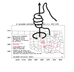
GRAVITY AND MAGNETIC INVESTIGATION OF THE AMES STRUCTURE, NORTH CENTRAL OKLAHOMA
http://principles.ou.edu/ames/index.html

Is the Ames Structure in Oklahoma a meteor impact site or the result of another electric universe discharge event?
GRAVITY AND MAGNETIC INVESTIGATION OF THE AMES STRUCTURE, NORTH CENTRAL OKLAHOMA
http://principles.ou.edu/ames/index.html
TomMagnetic Data
Although there is a large (~100 nT) negative anomaly centered about 8 km NE of the center of the Ames structure, its position suggests it may not directly relate to the Ames structure. On the other hand, the residual reduced-to-pole magnetic field reveals a 60 nT low nearly coincident with the gravity low and Sylvan structural low (Fig. 4). The radius of the magnetic anomaly is similar to the radius of the subsurface structural feature, and the radius of the gravity anomaly.
The magnitude and shape of the magnetic low over the Ames structure is similar to the magnitudes and shapes of negative magnetic anomalies observed over other impact craters, generally between tens to hundreds of nT, and may be due to shock demagnetization, shock remagnetization, and thermal and chemical remanent magnetization (TRM, CRM) effects (Pilkington and Grieve, 1992). However, the magnetic field associated with impact craters is more variable and typically less diagnostic than their gravity field (Grieve and Pesonen, 1992).
"The Pharisees and the scholars have taken the keys of knowledge and have hidden them. They have not entered nor have they allowed those who want to enter to do so. As for you, be as sly as snakes and as simple as doves." Gospel of Thomas http://www.gnosis.org/naghamm/gthlamb.html
-
MattEU
- Posts: 367
- Joined: Sun Jun 29, 2008 8:00 am
- Contact:
Re: Ames Structure Oklahoma?
that article gave the location of Ames Crater as 36.260 N 98.187 W, Earth Impact Database (http://www.unb.ca/passc/ImpactDatabase/images/ames.html) gave it as N 36° 15 W 98° 12

the one thing i can see clearly in this image that i can not in others is a central inner circle or (mound or central mini crater) inside Ames Crater and the opening into or out of the crater (the entry/exist point of the Birkeland Current that created if it is EU). Also it is near a river, is the Ames Crater the result of EDM spotting? Does the "tail" or little valley on the rim of Ames Crater shown above point towards the river?
Any other geological evidence in the area? if it is EU then you normally get other gEUlogy stuff. My first thought was its Oklahoma so Great Plains area so pretty flat but a quick look around the area gives off lots of EU stuff.
Glass Mountains (Gloss Mountains)
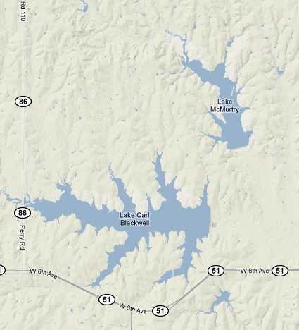
lake carl blackwell and lake mcmurty oklahoma - sharp erosion or lichtenberg figures?
Little Sahara State Park
And if sand is created suddenly by EU events then these perhaps strangely located sand dunes may be more evidence of EU
Great Salt Plains Lake
This other stuff does not prove Ames Crater is formed by the Electric Universe, as the beauty of craters is in the eye of the beholder, but from an EU eye they suggest that something happened in the area, and is perhaps still happening.
Ames Crater looks like it is either an impact crater or if its not then most impact craters are not by meteorites but possibly by EUFurthermore, the gravity signature of impact craters is relatively distinctive and the relationship between impact effects and density is somewhat straightforward. In fact, it is estimated that about one fifth of the known impact craters on Earth are covered with sediments, and gravity has been the major tool for investigation of these. The amplitude, shape, and character of gravity over the Ames Structure (Figure 8), for example, are consistent with observations from other structures believed to be caused by meteorite impact. Impact craters formed in sedimentary rocks with a diameter similar to the Ames structure (~15 km) generally produce negative gravity anomalies that extend to or slightly beyond the rim of the crater. The amplitude of the Ames gravity anomaly, about 1 mgal, is similar to that of other similar-sized astroblemes, when upward continuation of the buried structure's gravity field, from 3000 m to the surface, is accounted for.
http://geophysics.ou.edu/solid_earth/no ... /Ames3.htm
the one thing i can see clearly in this image that i can not in others is a central inner circle or (mound or central mini crater) inside Ames Crater and the opening into or out of the crater (the entry/exist point of the Birkeland Current that created if it is EU). Also it is near a river, is the Ames Crater the result of EDM spotting? Does the "tail" or little valley on the rim of Ames Crater shown above point towards the river?
Any other geological evidence in the area? if it is EU then you normally get other gEUlogy stuff. My first thought was its Oklahoma so Great Plains area so pretty flat but a quick look around the area gives off lots of EU stuff.
Glass Mountains (Gloss Mountains)
lake carl blackwell lake mcmurtyGloss Mountain State Park is located in the heart of a sporadic chain of red flat top mesas that meander across western Major County, Oklahoma.
SPARKLY STUFF
Whether you’re hiking or driving by on the highway, you’ll notice at various times that broken mirrors or glass seems to be reflecting light back at you. Actually, it is Selenite or what is often referred to as Isinglass that you are seeing. Three things cause you to see the Selenite better at certain times: rain, clouds, and the sun. The rain tends to wash the red dust or dirt off, and the clouds in combination with the sun seem to create spot light effects. If you take photos, you will notice how the clouds cause all types of effects. Sorry, but we haven’t figured any method for photographing the mountains and capturing the sparkly stuff.
http://www.okmajordev.org/gloss%20mount ... 20park.htm
lake carl blackwell and lake mcmurty oklahoma - sharp erosion or lichtenberg figures?
Little Sahara State Park
And if sand is created suddenly by EU events then these perhaps strangely located sand dunes may be more evidence of EU
Fasten your seat belts for one of Oklahoma’s most exciting state park adventures! Little Sahara State Park, with 1,450 acres of sand dunes ranging in height from 25 to 75 feet, offers the perfect playground for off-road vehicle enthusiasts, mixed in with some fascinating history.
The dunes originated over 11,000 years ago from terrace deposits and quartz left by the Cimarron River when it flowed across this area during the Pleistocene Age. Floodplain deposits left by the present-day river also contribute to the changing formations. This makes for a very, very fine quartz sand.
Early explorers of the area once called the dunes "walking hills." You can visit Little Sahara over and over again and never see the dunes exactly the same as the last trip. The wind and weather play an important part in the dunes shape and placement in Oklahoma’s geography- sand blows and reforms. These sand dunes "walk" about a foot north westward every year. In some cases in other states or countries, where the sand dune is today, won’t be where it is tomorrow. Little Sahara isn’t quite that bad, but you get the picture!
http://www.woodwardok.com/parks/littlesahara.htm
Great Salt Plains Lake
Great Salt Plains Lake is a reservoir in Alfalfa County, Oklahoma in the United States named because of the salt flats in the area and for the Salt Fork Arkansas River, which is dammed to form the lake. The average depth of the lake is only 3 feet (1 m) at normal pool. There is a location for digging selenite crystals in the salt flats which lie on the west edge of the lake.
This refuge is the only place in the world where selenite crystals with hourglass sand inclusions are found and are sought annually by thousands of visitors. Nowhere else in the world do crystals form with hourglass shapes inside and crystal fanatics can mine these "hourglass selenite" crystals, a seldom found and delicate form of selenite, which is a form of gypsum.
http://en.wikipedia.org/wiki/Great_Salt_Plains_Lake
This other stuff does not prove Ames Crater is formed by the Electric Universe, as the beauty of craters is in the eye of the beholder, but from an EU eye they suggest that something happened in the area, and is perhaps still happening.
-
tolenio
- Posts: 244
- Joined: Mon Mar 17, 2008 5:17 am
Re: Ames Structure Oklahoma?
Hello,
I believe that the Ames structure and its EU qualities explain a lot of the Oklahoma earthquakes. They have no tectonic fault to cause such events.


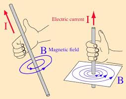
If the Ames structure creates an improved ground for charged particles, the negative qualities of the anomaly acting as a lightning rod, the magnetic force of periodic grounding would create magnetic force following the right hand rule. Over time this magnetic force builds up geologic pressure and periodically the geologic force is released when a good sized grounding of particles gives the area a magnetic force shove.
Canadian County and Garvin County both sotheast of Major County where the Ames structure is located, are earthquake seats for the area.
For me the question beomes will there be a sufficient discharge on ~February 2nd for such a geologic event.
Tom
I believe that the Ames structure and its EU qualities explain a lot of the Oklahoma earthquakes. They have no tectonic fault to cause such events.
If the Ames structure creates an improved ground for charged particles, the negative qualities of the anomaly acting as a lightning rod, the magnetic force of periodic grounding would create magnetic force following the right hand rule. Over time this magnetic force builds up geologic pressure and periodically the geologic force is released when a good sized grounding of particles gives the area a magnetic force shove.
Canadian County and Garvin County both sotheast of Major County where the Ames structure is located, are earthquake seats for the area.
For me the question beomes will there be a sufficient discharge on ~February 2nd for such a geologic event.
Tom
"The Pharisees and the scholars have taken the keys of knowledge and have hidden them. They have not entered nor have they allowed those who want to enter to do so. As for you, be as sly as snakes and as simple as doves." Gospel of Thomas http://www.gnosis.org/naghamm/gthlamb.html
-
MattEU
- Posts: 367
- Joined: Sun Jun 29, 2008 8:00 am
- Contact:
Re: Ames Structure Oklahoma?
can you put on that map where Ames Crater is and explain 2nd of Feb? is it to do with the full moon or something else?
have you got any other places where you think this happens or what evidence there will be showing that this is building up or releases? its an interesting idea and you always got to hand it to fleming for observing those rules
have you got any other places where you think this happens or what evidence there will be showing that this is building up or releases? its an interesting idea and you always got to hand it to fleming for observing those rules
-
tolenio
- Posts: 244
- Joined: Mon Mar 17, 2008 5:17 am
Re: Ames Structure Oklahoma?
Hello,
The Ames structure is located in Major County. The right hand rule is planted directly on top of Major County.
It all has to do with plasma grounding out. When high level plasma grounds out it creates a magnetic field and the right hand rule and a magnetic force is applied to the Earth in the area.
I sent this eamil to friend on Jan 30, 2010;
With my data if I knew particle density of these plasma bubbles I could predict elevated earthquake potenial dates at various locations and possibly magnitudes.
NASA is looking at the other end of these plasma grounding events with their Firefly mission investigating why the Earth has gamma ray emissions. On one end of the grounding you have gamma ray emissions and at ground level geologic pressure is applied due to the right hand rule.
Earthquake poetential should be able to be predicted with a 45 day lead time to areas with geologic pressure already at critical levels. That amounts to two Carrington rotations of the sun.
Tom
The Ames structure is located in Major County. The right hand rule is planted directly on top of Major County.
It all has to do with plasma grounding out. When high level plasma grounds out it creates a magnetic field and the right hand rule and a magnetic force is applied to the Earth in the area.
I sent this eamil to friend on Jan 30, 2010;
Today there is this news Feb 1, 2010;Hi Jamie,
I want to correct myself… The earthquake risk for California and Alaska rises starting tonight, and peaks on February 1st.
You can monitor here looking for red squares.
Latest Earthquakes in the USA - Last 7 days
USA earthquakes with M1+ located by USGS and Contributing Agencies.
http://earthquake.usgs.gov/earthquakes/recenteqsus/
There is a potential of an earthquake in Oklahoma State on February 2nd. Not a huge one, just a little one.
Haiti will get another shove on approximately February 4th. If there is stored geologic energy (built up plate pressure) it could be released.
I just counted wrong. Silly oversight. You are simply my advance witness.Later,
Tom
It is all about plasma grounding out to earth.Earthquake Felt in San Diego
San Diego 6 - 39 minutes ago
SAN DIEGO - An earthquake was felt over a wide area of San Diego Monday morning. The 5.0 magnitude earthquake struck at 6:20 am It was centered in the ...
5.0 Quake Hits Baja California KGTV, 10News.com
With my data if I knew particle density of these plasma bubbles I could predict elevated earthquake potenial dates at various locations and possibly magnitudes.
NASA is looking at the other end of these plasma grounding events with their Firefly mission investigating why the Earth has gamma ray emissions. On one end of the grounding you have gamma ray emissions and at ground level geologic pressure is applied due to the right hand rule.
Earthquake poetential should be able to be predicted with a 45 day lead time to areas with geologic pressure already at critical levels. That amounts to two Carrington rotations of the sun.
Tom
"The Pharisees and the scholars have taken the keys of knowledge and have hidden them. They have not entered nor have they allowed those who want to enter to do so. As for you, be as sly as snakes and as simple as doves." Gospel of Thomas http://www.gnosis.org/naghamm/gthlamb.html
-
tolenio
- Posts: 244
- Joined: Mon Mar 17, 2008 5:17 am
Re: Ames Structure Oklahoma?
Hi,
Just as NASA has an association with Earth's gamma ray emissions at the top end, lightning in the middle I say the bottom end has geologic activity;

In between all that is a moving bubble of solar plasma trapped within the magnetosphere and moving eastwards, moving towards weaker magnetic field areas.
Tectonic plate faults make EXCELLENT grounding points for the plasma bubbles to discharge when they cross them. Oklahoma has no tectonic fault, but it does have a large negative magnetic anomaly.
This could be the birth place of tornado alley. Air would also experience a right hand rule rotation.
Rain and low barometric pressure seems to trail these plasma bubbles. I would guess that the plasma is making the air denser in the vincinity of the plasma bubble, creating a trailing low.
Tom
Just as NASA has an association with Earth's gamma ray emissions at the top end, lightning in the middle I say the bottom end has geologic activity;
In between all that is a moving bubble of solar plasma trapped within the magnetosphere and moving eastwards, moving towards weaker magnetic field areas.
Tectonic plate faults make EXCELLENT grounding points for the plasma bubbles to discharge when they cross them. Oklahoma has no tectonic fault, but it does have a large negative magnetic anomaly.
This could be the birth place of tornado alley. Air would also experience a right hand rule rotation.
Rain and low barometric pressure seems to trail these plasma bubbles. I would guess that the plasma is making the air denser in the vincinity of the plasma bubble, creating a trailing low.
Tom
"The Pharisees and the scholars have taken the keys of knowledge and have hidden them. They have not entered nor have they allowed those who want to enter to do so. As for you, be as sly as snakes and as simple as doves." Gospel of Thomas http://www.gnosis.org/naghamm/gthlamb.html
-
tolenio
- Posts: 244
- Joined: Mon Mar 17, 2008 5:17 am
Re: Ames Structure Oklahoma?
Hello,
I would assume that the grounding events I mention would be accompanied by ball lightning. Luckily ball lightning is often reported by the average person for it is so unusual. It makes for good anecdotal reporting.
Ball Lighning reports Oklahoma;
Topographically the elevations drop off towards the east in Oklahoma.
Tom
I would assume that the grounding events I mention would be accompanied by ball lightning. Luckily ball lightning is often reported by the average person for it is so unusual. It makes for good anecdotal reporting.
Ball Lighning reports Oklahoma;
Spook Light road runs through the village of Hornet, OK and is located in the northeast corner in the state.This light has appeared seemingly as a ball of fire for almost 140 years, varying in size from a basketball to larger. It spins down the center of this gravel road (Spook Light Road) at great speed, rises up high, bobs and weaves to the right and left. It appears to be a large lantern, but there is never anyone carrying it. The light has appeared inside of vehicles, seems to retreat when it is pursued and never allows anyone to get to close to it. Does the light have some sort of intelligence? That remains just one of the many mysteries connected to this light.
No one has ever been injured by the light but many claim to have been frightened by it while walking down this road at night. Sometimes it just seems to come from nowhere and a few witnesses claim they have felt the heat from it as it passed close by them. Occasionally, some observer will even take a shot or two at the light, like Franklin Rossman, who lived near the Devil’s Promenade for years. He twice attempted to shoot the light with a “30-30” rifle but the shots had no effect whatsoever. He told an investigator to the site that he was unable to judge the distance to the light as it had such an odd look to it.

Topographically the elevations drop off towards the east in Oklahoma.
The Ames structure appears to be a plasma discharge point.Tornadoes and Ball Lightning
http://www.padrak.com/ine/ELEWIS3.html
Copyright 1995, 1996 by Edward Lewis
Abstract
Tornadoes and ball lightning are identified, and described as plasmoid phenomena. Certain anomalous characteristics of tornadoes and ball lightning are described and shown to be similar to the behavior of the plasmoid phenomena produced by electrolysis and discharge apparatus; in part, as evidenced by certain kinds of micrometer sized traces in nuclear emulsions and marks in materials.
I suspect that all phenomena is plasmoid phenomena, and that galaxies, atoms, and particles are plasmoids. Plasmoids seem to be basically an electrical-magnetic phenomena. In other articles(1,2), I've described plasmoids and plasmoid behavior extensively, and shown that plasmoids are responsible for the excess energy and transmutation effects observed in various kinds of "cold fusion" apparatus. In order to understand plasmoids and plasmoids effects, such as the micrometer size traces(3) Matsumoto has produced by the types of electrolysis and discharge apparatus(4,5,6) that researchers have most commonly been using, it is important to know about reported ball lightning and tornado behavior. In early 1993, I began to read extensively about anomalous reports of luminous tornadoes. There are many reports of this phenomena, including reports of people who have been inside tornadoes or seen into them from underneath. Those who have seen them from the inside or underneath report bright clouds, or light, or that the funnel was bright inside from much continuous lightning which "zigzagged" from side to side inside(7,8). According to Dessens(9) who catalogued tornadoes in France, about one-half of the tornadoes that he catalogued were either "furrowed by lightning, or the bottom of the tornado "vomits" balls of fire, or in short the tornado is luminescent at one place or another." The purpose of this article is to show evidence for identifying tornadoes and ball lightning as plasmoid pheomena.
Atmospheric Plasmoid Phenomena
A weather observer for the U. S. Weather Service named F. Montgomery(10) who was stationed in Blackwell, Oklahoma in May of 1955 reported a tornado that passed by in the evening at 9:27 P.M. that had a deep blue section that was near the top near the cloud layer and that was "very much brighter" than an arc welder and too bright for him to look at, though the tornado was 9 blocks or 3600 feet away from him. I suspect that the bright section may have been toroid shaped. He reported that the air from the tornado felt hot and that the temperature as recorded by a thermometer at his instrument shelter rose from 74 degrees Fahrenheit to 80 degrees Fahrenheit when the storm struck. This is evidence of a spectacular rate of radiation. And he reported:
Tom
"The Pharisees and the scholars have taken the keys of knowledge and have hidden them. They have not entered nor have they allowed those who want to enter to do so. As for you, be as sly as snakes and as simple as doves." Gospel of Thomas http://www.gnosis.org/naghamm/gthlamb.html
-
seasmith
- Posts: 2815
- Joined: Thu Mar 27, 2008 6:59 pm
Re: Ames Structure Oklahoma?
“ Just as NASA has an association with Earth's gamma ray emissions at the top end, lightning in the middle I say the bottom end has geologic activity;
In between all that is a moving bubble of solar plasma trapped within the magnetosphere and moving eastwards, moving towards weaker magnetic field areas.
Tectonic plate faults make EXCELLENT grounding points for the plasma bubbles to discharge when they cross them.
Hi Tolenio,
That is perfect example of earlier comments on completed
" aetheric circuits and cycles".
http://www.thunderbolts.info/wp/forum/phpB ... ?f=4&t=415
Your observations that geologic “faults make EXCELLENT grounding points” and of plasmoids as charge carriers are also EXCELLENT.
s
Who is online
Users browsing this forum: No registered users and 41 guests