There was an article about "Martian Blueberries in the Lab" that I think Wal mentioned, including pics of these little spherules that this gentleman created in some hematite powder with an electric arc.
I wonder if I could look him up on the web and ask if he ever dissected any of them to see if they were merely hollow, or if there was any crystalization inside? It's possible that he conducted similar experiments with other compounds, like perhaps sand. I wonder if he was able to create silica dioxide spherules that formed like a geode, or whether they simply glassified?
I would think that his work is probably closest to answering the question than anyones.
Mike H.
Earth - tectonics and geology
-
mharratsc
- Posts: 1405
- Joined: Mon Jan 26, 2009 7:37 am
Re: Huge Chunk Of Beach Uplifts 20' For No Reason
Mike H.
"I have no fear to shout out my ignorance and let the Wise correct me, for every instance of such narrows the gulf between them and me." -- Michael A. Harrington
"I have no fear to shout out my ignorance and let the Wise correct me, for every instance of such narrows the gulf between them and me." -- Michael A. Harrington
-
davesmith_au

- Site Admin
- Posts: 840
- Joined: Thu Mar 13, 2008 7:29 pm
- Location: Adelaide, the great land of Oz
- Contact:
Re: Huge Chunk Of Beach Uplifts 20' For No Reason
The lab-produced blueberries were made by Cj Ransom, a plasma physicist associated with our crowd. I don't think he cut any open, but I'll see if he will and get back here with the results, if possible.
Cheers, Dave.
Cheers, Dave.
"Those who fail to think outside the square will always be confined within it" - Dave Smith 2007
Please visit PlasmaResources
Please visit Thunderblogs
Please visit ColumbiaDisaster
Please visit PlasmaResources
Please visit Thunderblogs
Please visit ColumbiaDisaster
-
Osmosis
- Posts: 423
- Joined: Wed Mar 19, 2008 3:52 pm
- Location: San Jose, California
Re: Huge Chunk Of Beach Uplifts 20' For No Reason
I wonder of CJ Ransom tried just plain dirt? I have a nice arc welder-- Hmmm-- 
-
Florian
- Posts: 57
- Joined: Wed Jun 03, 2009 9:59 am
- Location: France
- Contact:
Re: Huge Chunk Of Beach Uplifts 20' For No Reason
Nothing mysterious in that news. This uplift is simply the product of a landslide. The bottom edge moved up pushed by the upper part, like on a ramp.I know many of us believe that a lot of the geologic formations we see are not a product of erosion or moving tectonic plates. This seems to provide proof of that.
--
Florian
All truth passes through three stages. First, it is ridiculed. Second, it is violently opposed. Third, it is accepted as being self-evident. Arthur Schopenhauer.
Florian
All truth passes through three stages. First, it is ridiculed. Second, it is violently opposed. Third, it is accepted as being self-evident. Arthur Schopenhauer.
-
mharratsc
- Posts: 1405
- Joined: Mon Jan 26, 2009 7:37 am
Re: Huge Chunk Of Beach Uplifts 20' For No Reason
Actually, one of the investigators suspected that it was a landslide from a fault plate below the current cliff line that slipped (they stated it was the site of a major landslide 10000+ years ago before the current cliffs were present), as the cliffs didn't go down towards the beach... the beach went UP towards the cliffs.
I suppose someone could do some soundings and see if the cove below the beach changed depth/topography at all- I would presume from the hypothesis stated above that the cove should be a bit deeper now.
However, I'm a person who believes that fault lines are also pathways for telluric currents (strange weather phenomena above fault zones, earthquake lights, etc being the prime drivers of this suspicion of mine) and thus I harbor another suspicion that perhaps increased current activity from the recent sunspot might've played an instigative part in this motion on this particular fault zone.
Time, and reading the news I surmise, will tell!
Mike H.
Mike H.
"I have no fear to shout out my ignorance and let the Wise correct me, for every instance of such narrows the gulf between them and me." -- Michael A. Harrington
"I have no fear to shout out my ignorance and let the Wise correct me, for every instance of such narrows the gulf between them and me." -- Michael A. Harrington
-
Grey Cloud
- Posts: 2477
- Joined: Sun Apr 13, 2008 5:47 am
- Location: NW UK
Re: Huge Chunk Of Beach Uplifts 20' For No Reason
Hi folks,
Here's a link to a similar(?) story:
The Durham Grand Canyon: Flooding after heavy rain carves vast trench in farm land
http://www.dailymail.co.uk/news/article ... -land.html
Ignoring the mandatory journalistic hyperbole:
Why has this 'raging torrent' only gouged a slot in the ground rather than a channel?
Okay so it was an usually heavy rain but why that spot at that time?
If I have the least bit of knowledge
I will follow the great Way alone
and fear nothing but being sidetracked.
The great Way is simple
but people delight in complexity.
Tao Te Ching, 53.
I will follow the great Way alone
and fear nothing but being sidetracked.
The great Way is simple
but people delight in complexity.
Tao Te Ching, 53.
-
mharratsc
- Posts: 1405
- Joined: Mon Jan 26, 2009 7:37 am
Re: Huge Chunk Of Beach Uplifts 20' For No Reason
Well they certainly didn't post the best pics possible of it, but nevertheless what I could see was indeed very, very interesting.
The photos from the article show a winding water path that-yes-looks like a canyon... but only 6 or so feet deep. I'm originally from Texas and very familiar with flash-flooding. Without a prior channel being there, that should've just skimmed the top off that field as all the water flowed across the "perfectly flat' terrain. If there had been even a small gully there it would've certainly got dug out deeper by the flow, but without the depth/width necessary to contain the volume of water, it would've washed out quite a swath to either side of it's banks.
Here's what I saw from the photos:
1. Steep walls of an almost even height,
2. Very little undercutting of the outer banks of curves, little or no slope on the inner curves,
Items 1 & 2 make me think of some kind of electrical excavation or rille, but...
3. The trickle of water down the middle of the ravine is meandering from inside curve to outside following 'path of least resistance' rather than following a deep cut down the center like you would expect of a rille,
4. The walls were collapsing, indicative that the surrounding earth became extremely saturated to quite a depth. A flash flood would not do that, so the ground had to have been pre-saturated. Water flowing over muddy ground will certainly behave differently than water flowing over dry ground with higher adhesion characteristics.
I think the jury is out on this one, as odd as it sounds. I'm not about to completely rule out electromagnetic effects, however. As many people have stated- water behaves as a sort of pseudo-plasma. It's entirely possible that the flow of the water through this area was affected by telluric currents in the field which might've caused more cohesion of the flow of the water itself, even if electric currents didn't do a big batch of excavating prior to the torrent running through that field. I noted in one of the pictures in the article that there was an irrigation pipe buried perpendicularly to the ravine at about half it's depth. On the right side of the picture you'll see that there is a cutout in the channel that heads in the direction of the pipe itself. Could the iron piple have affected the electromagnetic field and pulled some of the volume along it'se length?
Difficult to tell from the perspectives of the few pictures presented in the article. It's worth keeping in the file drawer tho, I think!
Mike H.
(Emphasis added by me)'I heard this rushing like Niagara Falls,' he said. 'And I could see this water wearing away the land. The field was perfectly flat 25 acres before. Now there's only about 18 acres left.
'It's an amazing phenomenon, but I estimate it's the result of water from up to 120 acres of flooded land.'
The photos from the article show a winding water path that-yes-looks like a canyon... but only 6 or so feet deep. I'm originally from Texas and very familiar with flash-flooding. Without a prior channel being there, that should've just skimmed the top off that field as all the water flowed across the "perfectly flat' terrain. If there had been even a small gully there it would've certainly got dug out deeper by the flow, but without the depth/width necessary to contain the volume of water, it would've washed out quite a swath to either side of it's banks.
Here's what I saw from the photos:
1. Steep walls of an almost even height,
2. Very little undercutting of the outer banks of curves, little or no slope on the inner curves,
Items 1 & 2 make me think of some kind of electrical excavation or rille, but...
3. The trickle of water down the middle of the ravine is meandering from inside curve to outside following 'path of least resistance' rather than following a deep cut down the center like you would expect of a rille,
4. The walls were collapsing, indicative that the surrounding earth became extremely saturated to quite a depth. A flash flood would not do that, so the ground had to have been pre-saturated. Water flowing over muddy ground will certainly behave differently than water flowing over dry ground with higher adhesion characteristics.
I think the jury is out on this one, as odd as it sounds. I'm not about to completely rule out electromagnetic effects, however. As many people have stated- water behaves as a sort of pseudo-plasma. It's entirely possible that the flow of the water through this area was affected by telluric currents in the field which might've caused more cohesion of the flow of the water itself, even if electric currents didn't do a big batch of excavating prior to the torrent running through that field. I noted in one of the pictures in the article that there was an irrigation pipe buried perpendicularly to the ravine at about half it's depth. On the right side of the picture you'll see that there is a cutout in the channel that heads in the direction of the pipe itself. Could the iron piple have affected the electromagnetic field and pulled some of the volume along it'se length?
Difficult to tell from the perspectives of the few pictures presented in the article. It's worth keeping in the file drawer tho, I think!
Mike H.
Mike H.
"I have no fear to shout out my ignorance and let the Wise correct me, for every instance of such narrows the gulf between them and me." -- Michael A. Harrington
"I have no fear to shout out my ignorance and let the Wise correct me, for every instance of such narrows the gulf between them and me." -- Michael A. Harrington
-
Grey Cloud
- Posts: 2477
- Joined: Sun Apr 13, 2008 5:47 am
- Location: NW UK
Re: Huge Chunk Of Beach Uplifts 20' For No Reason
Hi Mike,
I was thinking along similar lines to you. I would like to have seen a photo of the ends of this 'gully' as the aerial shot with the dotted lines seems to show that it closed and does not connect to the river (which must be lower than the surrounding land).
I would imagine the land was already wet to a greater or lesser degree (this is the UK not Texas ). I live in the NW and the incident was in the NE but summer hasn't been anything to write home about (we only know it's summer because the rain has got warmer).
The water at the bottom of the cut might just be the run-off that has accumulated since the event.
Also in the top image, the grass doesn't seem to be point in the direction of a flow, it' seems to be pointing inward. And how would there still be grass on the floor of the cut if there had been this raging torrent moving 'millions of gallons' of water (and that's UK gallons) and '12,000 cubic metres of soil' (shame on the Mail, mixing imperial and metric units).
Where did all this soil go if it didn't empty into the river? According to the dotted line image, the thing is running almost parallel with the river. Also there appears to be a small wood at the top end.
The article also mentions another, smaller gully 'six feet deep and 600ft long.' Funny they both do 6ft deep.
Anyone do Google Earth? It might show where the soil went (brown on green?)
I was thinking along similar lines to you. I would like to have seen a photo of the ends of this 'gully' as the aerial shot with the dotted lines seems to show that it closed and does not connect to the river (which must be lower than the surrounding land).
I would imagine the land was already wet to a greater or lesser degree (this is the UK not Texas
The water at the bottom of the cut might just be the run-off that has accumulated since the event.
Also in the top image, the grass doesn't seem to be point in the direction of a flow, it' seems to be pointing inward. And how would there still be grass on the floor of the cut if there had been this raging torrent moving 'millions of gallons' of water (and that's UK gallons) and '12,000 cubic metres of soil' (shame on the Mail, mixing imperial and metric units).
Where did all this soil go if it didn't empty into the river? According to the dotted line image, the thing is running almost parallel with the river. Also there appears to be a small wood at the top end.
The article also mentions another, smaller gully 'six feet deep and 600ft long.' Funny they both do 6ft deep.
Anyone do Google Earth? It might show where the soil went (brown on green?)
If I have the least bit of knowledge
I will follow the great Way alone
and fear nothing but being sidetracked.
The great Way is simple
but people delight in complexity.
Tao Te Ching, 53.
I will follow the great Way alone
and fear nothing but being sidetracked.
The great Way is simple
but people delight in complexity.
Tao Te Ching, 53.
-
Lloyd
- Posts: 4433
- Joined: Fri Apr 04, 2008 2:54 pm
Re: Geodes etc
* Does today's TPOD crater http://thunderbolts.info/tpod/2009/arch ... 24dome.htm ...
1.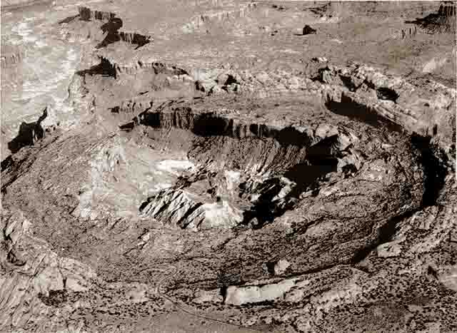
...resemble a geode much?
2.
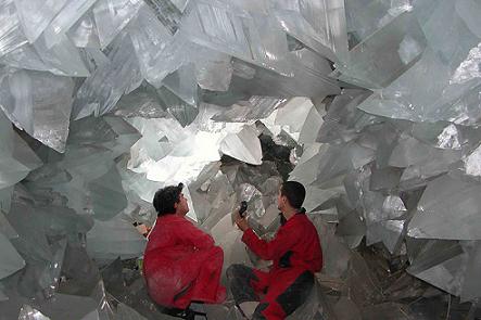
* This site http://www.unique-almeria.com/what-is-a-geode.html actually calls this cave a geode.
3.
* That's similar to this TPOD http://thunderbolts.info/tpod/2007/arch ... averns.htm
* I was pleased to note that the article with today's TPOD mentioned that electric arcs, i.e. lightning, can produce shattercones that are found at impact sites such as the above crater. Since lightning travels at extremely supersonic speeds, it's natural that, when it strikes the ground, its matter will impact the ground at tremendous speed and be able to form those shattercones. Some have been found to be magnetized, which is a giveaway that the cause is electrical, rather than mechanical.
1.
...resemble a geode much?
2.
* This site http://www.unique-almeria.com/what-is-a-geode.html actually calls this cave a geode.
3.
* That's similar to this TPOD http://thunderbolts.info/tpod/2007/arch ... averns.htm
* I was pleased to note that the article with today's TPOD mentioned that electric arcs, i.e. lightning, can produce shattercones that are found at impact sites such as the above crater. Since lightning travels at extremely supersonic speeds, it's natural that, when it strikes the ground, its matter will impact the ground at tremendous speed and be able to form those shattercones. Some have been found to be magnetized, which is a giveaway that the cause is electrical, rather than mechanical.
-
biknewb

- Posts: 59
- Joined: Tue Mar 18, 2008 7:27 am
- Location: Netherlands
Re: Huge Chunk Of Beach Uplifts 20' For No Reason
This is some puzzle!
Even though it looks like one, electrical excavations have their own rules to obey: they throw the material up in the sky, but it has to come down. Main question regardless of the mechanism: where did the soil go?
Possibly this started as an underground stream?
Even though it looks like one, electrical excavations have their own rules to obey: they throw the material up in the sky, but it has to come down. Main question regardless of the mechanism: where did the soil go?
Possibly this started as an underground stream?
-
biknewb
- Posts: 59
- Joined: Tue Mar 18, 2008 7:27 am
- Location: Netherlands
Re: Huge Chunk Of Beach Uplifts 20' For No Reason
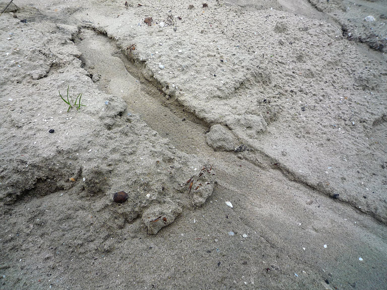
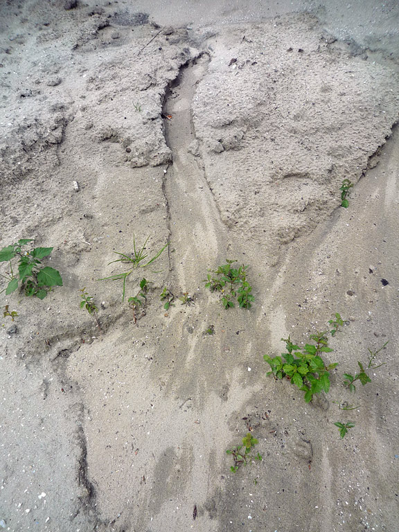
One never is too old to learn. I just came across a small scale version of The Durham Grand Canyon. See photo's here and here.
This is a small trough cut by rainwater running off a hill of sand. Notice the steep sides. The thing I learned was that it also starts with a steep sided edge. No gradual inflow.
The outflow is very obvious here; I'd love to see photo's of the outflow in Durham.
This is a small trough cut by rainwater running off a hill of sand. Notice the steep sides. The thing I learned was that it also starts with a steep sided edge. No gradual inflow.
The outflow is very obvious here; I'd love to see photo's of the outflow in Durham.
-
mharratsc
- Posts: 1405
- Joined: Mon Jan 26, 2009 7:37 am
Re: Huge Chunk Of Beach Uplifts 20' For No Reason
Very similar indeed. There is one other difference however (besides the scale)- the topography of the sand is not as flat as what was stated in the article.
An "almost perfectly flat" area of sand that gets rained on would become a sink, since sand doesn't pack as well as other soils. You would develop a subterranean water table, and the water would exit downhill from the little 'aquifer' and create a little river with much resultant erosion (much as the first link you posted shows almost a crater-like start to the small gulch just below the top of the little ride in the photograph.)
I do believe that the same thing could've happened in this field from the original article, however the key to it is understanding the topology of the terrain there... hence why I posted the emphasis on the quote about it being almost perfectly flat in that field.
I'm interested to see if anyone posts more specific info regarding the lay of the land there, inclination towards the river, etc, before I make up my mind about that one!
Mike H.
Mike H.
"I have no fear to shout out my ignorance and let the Wise correct me, for every instance of such narrows the gulf between them and me." -- Michael A. Harrington
"I have no fear to shout out my ignorance and let the Wise correct me, for every instance of such narrows the gulf between them and me." -- Michael A. Harrington
-
mharratsc
- Posts: 1405
- Joined: Mon Jan 26, 2009 7:37 am
Re: Geodes etc
Lloyd- that is freakin brilliant!
That's the first I've heard of someone comparing something like this to a cracked geode, and sure enough there's a striking similarity there!
What if that "crater" actually started out as a dome?? I remember when I was a kid in Texas- a friend of mine and I camped out at a place called Enchanted Rock:
http://www.tpwd.state.tx.us/spdest/find ... nted_rock/
Excerpt:
And more- what if that cavern down in Mexico is a big arse geode as well, and the spelunkers went inside it? Everyone is so taken by the size of the crystals inside the thing, and the intense heat, and the noxious gas- did anyone ever bother to check to see if the cavern was spherical? What the composition of the rock was adjacent to the crystal, and against the surrounding rock strata?
If they were to discover that there were actually geodes of that size in locations around the planet- I would really think twice about that Hollow Earth theory, I swear...
Mike H.
That's the first I've heard of someone comparing something like this to a cracked geode, and sure enough there's a striking similarity there!
What if that "crater" actually started out as a dome?? I remember when I was a kid in Texas- a friend of mine and I camped out at a place called Enchanted Rock:
http://www.tpwd.state.tx.us/spdest/find ... nted_rock/
Excerpt:
They say that it was the top of a lava tube that pushed up but never surfaced. What if it's not? What if it's nothing more than a friggin big geode??Tonkawa Indians believed ghost fires flickered at the top, and they heard weird creaking and groaning, which geologists now say resulted from the rock's heating by day and contracting in the cool night.
And more- what if that cavern down in Mexico is a big arse geode as well, and the spelunkers went inside it? Everyone is so taken by the size of the crystals inside the thing, and the intense heat, and the noxious gas- did anyone ever bother to check to see if the cavern was spherical? What the composition of the rock was adjacent to the crystal, and against the surrounding rock strata?
If they were to discover that there were actually geodes of that size in locations around the planet- I would really think twice about that Hollow Earth theory, I swear...
Mike H.
Mike H.
"I have no fear to shout out my ignorance and let the Wise correct me, for every instance of such narrows the gulf between them and me." -- Michael A. Harrington
"I have no fear to shout out my ignorance and let the Wise correct me, for every instance of such narrows the gulf between them and me." -- Michael A. Harrington
-
Grey Cloud
- Posts: 2477
- Joined: Sun Apr 13, 2008 5:47 am
- Location: NW UK
Re: Huge Chunk Of Beach Uplifts 20' For No Reason
Hi Mike,
Best I could come up with:
http://www.thenorthernecho.co.uk/search ... g_feeling/
http://www.sunderlandecho.com/news/Durh ... 5493639.jp
That pipe did well to survive the torrent?
This one has short video from the BBC news:
http://www.wsmweather.co.uk/?p=1610
Best I could come up with:
http://www.thenorthernecho.co.uk/search ... g_feeling/
http://www.sunderlandecho.com/news/Durh ... 5493639.jp
That pipe did well to survive the torrent?
This one has short video from the BBC news:
http://www.wsmweather.co.uk/?p=1610
If I have the least bit of knowledge
I will follow the great Way alone
and fear nothing but being sidetracked.
The great Way is simple
but people delight in complexity.
Tao Te Ching, 53.
I will follow the great Way alone
and fear nothing but being sidetracked.
The great Way is simple
but people delight in complexity.
Tao Te Ching, 53.
-
mharratsc
- Posts: 1405
- Joined: Mon Jan 26, 2009 7:37 am
Re: Huge Chunk Of Beach Uplifts 20' For No Reason
Well this one has a conventional (albeit rather surprising!) explanation then- it's a former riverbed!
Well, not all of them are going to be corroborative to EU theory, but... one thing still strikes me as pretty amazing about this:
WHO the heck was the pipefitter who did that cast iron irrigation pipe, and WHAT the heck did he use to sweat those pipes together that withstood that godawful torrent?!
Man deserves a pat on the back for that kind of quality work!
Mike H.
Mike H.
"I have no fear to shout out my ignorance and let the Wise correct me, for every instance of such narrows the gulf between them and me." -- Michael A. Harrington
"I have no fear to shout out my ignorance and let the Wise correct me, for every instance of such narrows the gulf between them and me." -- Michael A. Harrington
Who is online
Users browsing this forum: No registered users and 26 guests