Questioning the Ice Ages

Historic planetary instability and catastrophe. Evidence for electrical scarring on planets and moons. Electrical events in today's solar system. Electric Earth.

Moderators: MGmirkin, bboyer

Locked
User avatar
GaryN
Posts: 2668
Joined: Tue Apr 01, 2008 8:18 pm
Location: Sooke, BC, Canada

Re: Questioning the Ice Ages

Unread post by GaryN » Mon Jul 30, 2012 11:32 am

@webo
Kannesteinen Rock is apparently made of gneiss
Well, the geologists must have differing opinions, as my searches say it is Eclogite, and I think the Eclogite is an example of surface transformation by 'fire'. According to Wiki it is an Ultra High Pressure metemorhic rock.
Eclogites record pressures in excess of 1.2 GPa (45 km depth) at >400–1000 °C and usually in excess of 600-650 °C. This is high-pressure, medium- to high-temperature metamorphism.
http://en.wikipedia.org/wiki/Eclogite
So the rock has come from 45 Km below the surface?
We also have a good number of petroglyphs on the islands around here, and if the "squating man" is indeed a representation of events seen in the sky, then there is perhaps supporting evidence of catastrophe, but how long ago could that have been if the petroglyphs are still so pronounced?
http://qmackie.files.wordpress.com/2010 ... .jpg?w=500
A petroglyph that has taken a pounding for, how long? And it hasn't fully worn away.
http://www.svdreamchaser.net/Petroglyph.JPG
The bottom of that rock also shows how the rock is weathered by water, sand, and rocks, it is quite rough to the touch, so the glassy smooth boulders found in some beach areas would seem not to have been from weathering, but I believe, by a high temperature surface glazing.
My estimate is that it would have taken many thousands of years for the Kannestein Rock to have been worn away like that by wind and water, even if the sea level had been as high as it is now for those thousands of years.
In order to change an existing paradigm you do not struggle to try and change the problematic model. You create a new model and make the old one obsolete. -Buckminster Fuller

finno
Posts: 31
Joined: Wed Jul 18, 2012 9:18 am

Re: Questioning the Ice Ages

Unread post by finno » Tue Jul 31, 2012 12:35 am

This in very good writing from Mars hollow holes. Thanx of lot.
http://www.thunderbolts.info/wp/2012/07 ... at-a-hole/

im pretty sure, there is not long way proof, potholes on earth can be also born at same way. somekind rolling electrical pillar. Is here anybody who can explain that physically?

User avatar
webolife
Posts: 2539
Joined: Mon Mar 17, 2008 2:01 pm
Location: Seattle

Re: Questioning the Ice Ages

Unread post by webolife » Tue Jul 31, 2012 5:24 am

Some clarifications, maybe...
Descriptions of the Kannesteinen rock include that it is gneiss containing some eclogite.
Working backwards, gneiss is a high pressure/high heat metamorphic rock derived from shist which comes from slate, which comes from shale, metamorphosed mudstone, presumably of surface deposited origin.
Gneiss occurs in orogenic episodes, not just at depth below overburden, as evidenced by its high incidence in mountain ranges. At least that's where it generally originates. I pick up lots of pieces of it from the beach, which relative to this thread, probably[?] arrived there rafted upon glaciers.
Because gneiss is composed of relatively large crystals, it is subject to rapid weathering, readily provided by water, wind and exposure to rapid temperature fluctuations at the seashore.
None of this excludes the possibility of exotic electrical action, it just doesn't require it...
Compared to humans, rock is hard and seemingly enduring. Compared to physical/mechanical/chemical/biochemical/natural weathering processes, rock is fragile and malleable.
Truth extends beyond the border of self-limiting science. Free discourse among opposing viewpoints draws the open-minded away from the darkness of inevitable bias and nearer to the light of universal reality.

User avatar
GaryN
Posts: 2668
Joined: Tue Apr 01, 2008 8:18 pm
Location: Sooke, BC, Canada

Re: Questioning the Ice Ages

Unread post by GaryN » Tue Jul 31, 2012 2:19 pm

None of this excludes the possibility of exotic electrical action, it just doesn't require it...
Well of course it's always good to have challenges to any idea, especially one that claims to put the standard model of geology in grave doubt. I don't want to go off half-cocked to our local university geology department with ideas that can be shown to be preposterous, and be made to look a total fool. However, I think, as the saying goes, "look after the small stuff, and the big stuff will take care of itself", that the small stuff, the odd, very localised formations that, to me, defy a simple mechanical model based on the known properties of the rock, the abrasive properties of wind, water, sand and rock, will show that these features could not have formed given even millions of years of a gradualist model.
What has happened here is that geologists have looked at the big picture (I'm using Vancouver Island with this scenario) and reasoned that the deep canyons and valleys must have been formed by glacial action, and for that amount of material to have been removed, to such depths, there must have been X depth of ice sufficient to provide the pressure needed for the mechanism to work. The smaller features are just odd, random side effects of the main mechanism.
I propose we instead start with the smaller scale observations, and study how they could have formed, given the known properties of the materials involved. Computer simulations should be able to model these much smaller scale features quite easily, and be able to say if it is even possible for them to have been formed by any known process, and if so, how long it would have taken.
I'd bet that they could not produce the observed features with any amount of tweaking of the model, and that anything that came even close in form would require inordinate periods of time. My confidence in this matter has been boosted by having access to a retired field geologist with many years of experience, who can not offer any conventional explanation for some of the features I have pointed out to him, particularly in regards to the apparent age of the features, as they all have, geologically speaking, a very recent appearance. If the small stuff can not be explained with any degree of certainty, then surely we have to question the model of the big stuff. I'm not saying the Earth has never undergone even prolonged periods of cold, and we still have ice fields and glaciers on Vancouver Island, but rather that the ice was never so thick, and that it's movement so slow, perhaps even stationary, that the accepted erosion models could not possibly work.
I think your estimates for the rate of wear by wind and water are hugely off the mark, webo. In my own, small, seasonal creek, there is one small section in the V at the base where it is pillow lava bedrock on one side, and a 6 inch thick conglomerate capping on the bedrock on the other side. A 4 inch diameter rock is protruding almost half way out of the conglomerate, exposed to the water flow, but in 30 years there has been no apparent change in the conglomerate, the rock is no more exposed than it was when I first looked at it. This is in the very bottom of the creek, and the water moves very quickly through what is only about a 6 inch wide constriction. Also, I have been visiting some of the same beaches for over thirty years, and there has been no noticeable change to the rocky outcrops, either in the basalt or the often sharp edged sandstone and conglomerates. I do realise that time and my memory may factor into my perceptions though!

My next proposal, though perhaps not fully original, as finno pointed out with his mention of Keijo Parkkunen, extends the tornado model to the formation of the boulders found in the creeks and rivers. I do not know if Parkkunen did propose such, perhaps finno could provide clarity there?

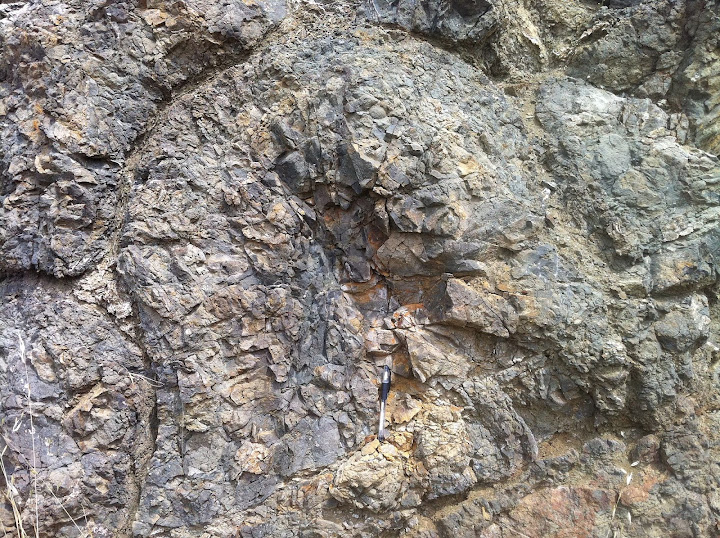
As opposed to large areas that seem to have been transformed by electricity and heat, the V shaped canyons would seem to have been torn out by an electric tornado. I have been doing some field geology, starting with my own relatively small creek, but it seems even the larger ones adhere to the same pattern. The V shaped creek bed, the almost vertical, rounded outcrop side walls, angular blocks and plates of rock that look like they have been ejected from the side walls, and the roundish pebbles, from 1/4 inch to a couple of feet diameter, of a wide variety of colour and crystal size, some having so smooth a surface they suggest vitrification.
Where the V becomes less pronounced, the valley exhibits lumpy outcrops, so there is a stepped appearance, and higher up still, the edges become sharper and the shapes more angular.
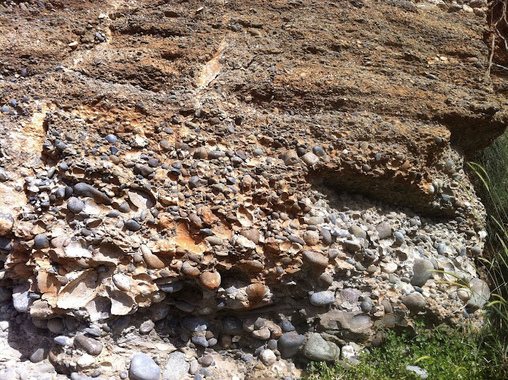
Totally covering the stepped outcrops at the lower reaches is a very fine red-ish powder, devoid of organic material, apart from about 4 inches at the surface, from organic decay of the forest flora. In the dust there are pebbles and rocks from tiny to perhaps 8 or 10 inches in diameter, and the dust almost completely hides the underling rock, filling the steps so it appears to be just a dirt slope. Further up there is less of the pebble and rock containing dust, and the outcrops are more visible. Traversing the creek bed, the amount of dust and debris gets progressively less, the pebbles smaller on average, and maybe a couple of hundred yards from the creek, we are back to the bare, mound shaped bedrock. It looks to me then, much like the debris field from a tornado, where the dust is lofted to great height, while the larger objects fall out of the funnel much nearer to the point of contact.
Image
I would have to say that it appears the pebbles and even the larger boulders, are the material that was originally a hill, melted and sucked out, shaped in a plasma/current pinch, and hurled up and away, and falling back with a reduction in both size and density of components as you get further from the creek. The angular nature of the outcrops and rock faces higher up suggests that a strong electric field caused separation along existing planes in the rock, formed in the cooling of the originally molten bedrock. The angular blocks also exhibit no change in colour or crystal size from the original rock surrounding the area, so little or much less heat was involved. In the bigger creeks or rivers, there are sometimes thousands of boulders lying in long pools along the water course, of a great variety of colours and textures. The standard model has these as being pushed down the coast by glaciers, becoming rounded over very long periods, and then being trapped in the creeks and rivers as the glaciers retreated and the Island rebounded, offering an explanation as to why the boulders are found almost to the very highest elevations.
At first glance it appears the same characteristics just scale up with the size of the creek or river canyons, including the average size and quantity of the boulders and the lateral extents of the dust and rock coverage. It would seem that the boulders are formed in a pinch at the base of a vortex where the energies are at their most powerful, and that the size, shape, colour and crystal size variations are due to the time spent in the pinch and the nature of the energies at any given moment during the process. The rocks which conventionally require a formation at great depths and pressures may have formed almost instantly.
The largest boulders remain in the creek, or close by, while the smaller ones are flung further away, and the fine dust travels the furthest. Yes, it is only conjecture, but just the fact that this fine dust is still present in large amounts on very steep slopes would indicate a very recent origin with minimal washing away considering this is a temperate rain forest with seasonally heavy downpours. I obviously need to perform more field work to see if the model is consistent, but it at least seems plausible, to my mind anyway.
Whew. Hope that all reads OK. :D
In order to change an existing paradigm you do not struggle to try and change the problematic model. You create a new model and make the old one obsolete. -Buckminster Fuller

User avatar
webolife
Posts: 2539
Joined: Mon Mar 17, 2008 2:01 pm
Location: Seattle

Re: Questioning the Ice Ages

Unread post by webolife » Wed Aug 01, 2012 8:19 am

Reads ok. We have the same intent... challenging the uniformitarian model.
We just have different suppositions about it. This is good for science, and I hope we're still around to see who's right :D
Truth extends beyond the border of self-limiting science. Free discourse among opposing viewpoints draws the open-minded away from the darkness of inevitable bias and nearer to the light of universal reality.

User avatar
GaryN
Posts: 2668
Joined: Tue Apr 01, 2008 8:18 pm
Location: Sooke, BC, Canada

Re: Questioning the Ice Ages

Unread post by GaryN » Wed Aug 01, 2012 4:10 pm

My field geologist friend sugested I look at Kellys Island, nothern Ohio, for examples of glacial grooving. Pretty impressive, and for a short while there was a shadow of a doubt in my mind about a plasma explanation.
Image
Pretty conclusive, by the looks of it. A little further image searching though brought up this image.(image too big)
http://www.funcoast.com/files/story/ima ... rooves.jpg
Doesnt the apparent U-turn at the bottom of the image beg some serious questions about the glacial method? And could anyone calculate the pressure needed for a rock or boulder to cut a groove so deep into the bedrock?
In order to change an existing paradigm you do not struggle to try and change the problematic model. You create a new model and make the old one obsolete. -Buckminster Fuller

User avatar
davesmith_au
Site Admin
Posts: 840
Joined: Thu Mar 13, 2008 7:29 pm
Location: Adelaide, the great land of Oz
Contact:

Re: Questioning the Ice Ages

Unread post by davesmith_au » Wed Aug 01, 2012 5:00 pm

GaryN wrote:... A little further image searching though brought up this image.(image too big)
http://www.funcoast.com/files/story/ima ... rooves.jpg
Here ya go:
glacial_grooves_not_258x400.jpg
Hmmmmm, I see your point ...
"Those who fail to think outside the square will always be confined within it" - Dave Smith 2007
Please visit PlasmaResources
Please visit Thunderblogs
Please visit ColumbiaDisaster

User avatar
GaryN
Posts: 2668
Joined: Tue Apr 01, 2008 8:18 pm
Location: Sooke, BC, Canada

Re: Questioning the Ice Ages

Unread post by GaryN » Thu Aug 02, 2012 11:37 am

Thanks Dave.
Hmmmmm, I see your point ...
I have a growing list of geological forms that make, to me, no mechanical sense. I'd like to have a group of experts from various disciplines look at them and offer their opinions of how they were formed, and just see how much the opinions differed. If there were to be agreement that some of them could not possibly be produced by the methods presently accepted, then we have to look at alternatives, and I can only imagine but one alternative. I think it is only by looking at the smaller details first, and then working up to the bigger ones, that the TB/EU proposals of large scale catastrophic events, on Earth and the rest of the Solar system, can gain a solid foothold.
While looking into pillow lava, I landed on this site, which seems very informative of the conventional view of geology, but even though I do not have the time to look at the site in detail just now, some of the images and descriptions raise even more questions about the standard model.
http://www.sandatlas.org/page/3/
One example. This image suggests to me a lightning strike, and I have seen very similar formations on Vancouver Island. Radial cracks, a hole blown out, and an overall 'violent' appearance to the surrounding rock.
Image
In order to change an existing paradigm you do not struggle to try and change the problematic model. You create a new model and make the old one obsolete. -Buckminster Fuller

finno
Posts: 31
Joined: Wed Jul 18, 2012 9:18 am

Re: Questioning the Ice Ages

Unread post by finno » Fri Aug 03, 2012 2:27 am

Im been thinking all this staff, what you folks gived to me. One mystery is – what is this electric wind? Where it come from?
I got grazy idea, it can be same like Aurora borealis or northern lights. If Cardona is right, and theres been supermassive electric storm at north pole, then northern light coming also strongest and strongest. And it moves ofcourse, to south when electric storm is strongest and come back to north, when its weakness.

Sometimes northern lights can touch to earth ground. That happens in here when russians blowed atombombs in Novaja Zemlija and Murmansk. Then camed so strong neutroncloud, what connected to northern lights, and lights camed down ja down – even to ground.

but how northern lights can make striations? This can be absurd idea, but today we know, aurora borealis can be noise. It keeps sound (im hearing myself too, it sounds like breaking ice in moving river..srrrrr). What makes my things to cymatics. http://en.wikipedia.org/wiki/Cymatics

In here is one picture what are done with sound. It looks like striations, right?
http://www.flickr.com/photos/13868867@N ... 3355981738
and in this is very intresting videoclip
http://www.youtube.com/watch?v=GtiSCBXb ... e=youtu.be

Electric force and resonance…what else we need?

User avatar
GaryN
Posts: 2668
Joined: Tue Apr 01, 2008 8:18 pm
Location: Sooke, BC, Canada

Re: Questioning the Ice Ages

Unread post by GaryN » Fri Aug 03, 2012 9:08 pm

Electric force and resonance…what else we need?
Cymatics has been much discussed on the TB site, and I do imagine it to have at least some role in certain formations. It seems that Dust Acoustic Waves are produced in the ionosphere by lightning, sprites and blue jets, so at a time of much greater atmospheric electrical activity the DAWs may have had a strong influence on shaping surface features, especially when the surface was most likely to have been softened or even molten from heating by electron flows through the bedrock. I think this is perhaps where wrong assumptions have been made, by thinking that the heat has always come from deep below.
I have often wondered, looking at some of the well defined layers of sandstone and rocks in exposed cliff walls just how they got like that. Were there tsunamis that deposited these layers, or huge storms, outbursts from sediment and rock loaded glacial lakes? I'm now tempted to look to the heavens for some of the answers. If we had huge amounts of material being ripped from the surface, being formed sometimes into rocks of various sizes, shapes and colours, then falling back to earth, along with the dust, might we not have an alternative explanation for these features?
This is fluvial (river-channel) deposit from the Pleistocene near the village of Kouklia in southwestern Cyprus. The large boulders are mostly gabbro and diabase. These rocks were carried here from the Troodos ophiolite which is about 30 kilometers upstream.
Image

There would appear to be grading by particle size in the deposit, to be expected I thought. Then this afternoon, I was out having a closer look at the pillow lava in my creek bed, and I stopped to look at a catchment I made to collect the rainy season sand, gravel and rocks that wash down from further upstream. I use it for grading paths and trails and building up the banks of the creek. I have dug out a cubic yard or two every year and I know for fact, that the largest rocks stay on top and grade down to sand and fine silt! This image, if not taken out of context, would seem to indicate the material came from above, by way of the same process mentioned previously of larger material not being lofted as high, thus falling out first. The dust would be the last to settle, as the image seems to show. Interestingly, I thought, is that the variety of the rock types and colours is identical to what I see around here, which makes me wonder if glaciers ever reached Cyprus?
In order to change an existing paradigm you do not struggle to try and change the problematic model. You create a new model and make the old one obsolete. -Buckminster Fuller

User avatar
GaryN
Posts: 2668
Joined: Tue Apr 01, 2008 8:18 pm
Location: Sooke, BC, Canada

Re: Questioning the Ice Ages

Unread post by GaryN » Mon Aug 06, 2012 12:43 pm

Im been thinking all this staff, what you folks gived to me. One mystery is – what is this electric wind? Where it come from?
In a major event I think it would be a proton wind from the Sun, a proton storm. A proton is a hydrogen ion, and that is the primary component to reach the Earth surface. Yes, normally they enter at the poles and de-ionise somewhere above the Earth, though as you say they can touch the ground. The other possibility is the Van Allen belts, perhaps they increase in size and energy in a solar event, and swell enough so the inner, proton belt, contacts the surface? I don't know if enough energy could be developed there to cause some of the huge features like the Grand Canyon though.
If a proton stream were to reach the earth at other locations, it would likely flow like a river over the surface, and cause disaggregation of the surface. I would say that this is the cause of the great Sand Seas around the world, as the grain size in some deserts is so consistent that it is sought out by silicon wafer producers for the electronics industry. The volume of these seas is immense, hard to image it is all from normal surface abrasion by wind, and the grain size consistency is another clue to electrical production.
Aggregation and disaggregation in electric fields, particularly pulsed fields is, I believe, very important in many ways to the Earths surface feature formations, but is not recognised by standard model geologists. Sedimentary rock may well be due to aggregation in a dielectric fluid such as water, rather than a mechanical method, with the presence of various ions affecting the crystal structure formation. I think the often very well defined layers would be better explained by the electrical mechanism too.
Particles that form a sedimentary rock by accumulating are called sediment. Before being deposited, sediment was formed by weathering and erosion in a source area, and then transported to the place of deposition by water, wind, ice, mass movement or glaciers which are called agents of denudation.
http://en.wikipedia.org/wiki/Sedimentary_rock
The erosion in the source area was more likely by electrical methods, wind no doubt helped spread it around, mass movement of glaciers, well, I'm moving away from that one as a primary cause.

Destructive processes:
The mechanisms for destructive actions of pulsed electric fields is being examined.
Breakdown and destruction of heterogeneous solid dielectrics by high voltage pulses.
A mechanism explaining the breakdown of dielectrics with high intrinsic inhomogeneity like natural rocks and concrete is proposed and proved experimentally. This work has a very promising industrial application in the drilling and demolition of natural and artificial solid materials by electric pulses.
SELFRAG is using such mechanisms.
Like natural lightning a SELFRAG plant creates repetitive electrical discharges. It applies the electrical energy to materials immersed in a process liquid. Dielectric liquids, like water, have a high dielectric strength when voltage rise time is kept below 500 ns. As a result discharges are forced through the immersed material. The introduced electrical energy is then transformed into an acoustical shockwave resulting into a huge tensile stress regime within the material.
http://www.selfrag.com/index.php

It seems to be that electrical processes should receive far greater attention than they do, in surface and near surface geology at least. I see the disaggregation process is being used to 'crush' rock in archaeology, and the process works so well that even tiny fossils are complete and undamaged after the process.
Electric pulse rock sample disaggregator
http://ieeexplore.ieee.org/xpl/login.js ... r%3D960990
In order to change an existing paradigm you do not struggle to try and change the problematic model. You create a new model and make the old one obsolete. -Buckminster Fuller

seasmith
Posts: 2815
Joined: Thu Mar 27, 2008 6:59 pm

Re: Questioning the Ice Ages

Unread post by seasmith » Mon Aug 06, 2012 5:09 pm

Pulse power offers an attractive alternative. When a sufficiently powerful, short-duration, pulsed electric field is applied to rock particles between electrodes submerged in water, extensive ionization occurs along mineral grain boundaries. Electrical breakdown of the rock occurs along the ionized paths, creating high peak current flow and high internal tensile stress between the mineral grains. The result is selective fracture, breaking up the rock along internal grain boundaries (disaggregation)
http://ieeexplore.ieee.org/xpl/login.js ... r%3D960990


Gary,

Cognizant of the tremendous power of pulsed current to disaggregate minerals (a similar diffusion and dispersion of charge along atomic and granular boundaries is at work in the carbon-arc and plasma-arc cutting of metals),
and have no doubt sky-borne electric currents are responsible for many geologic wonders here on Earth's surface.
Your comments about "sand seas" made me wonder tho: What do you think the parent Rock was that electric disaggregation rendered into the homogenous sands ?
Were there other parent constituents? If so, wherede go ?

cheers

Lloyd
Posts: 4433
Joined: Fri Apr 04, 2008 2:54 pm

Re: Questioning the Ice Ages

Unread post by Lloyd » Mon Aug 06, 2012 6:23 pm

Sand from Venus?
* I believe Gary Gilligan thinks the world's desert sands come from a close approach of Venus a few thousand years ago. Here's one of his TPODs: http://www.thunderbolts.info/tpod/2010/ ... sahara.htm
Sandstone under the Sahara
* There's some interesting info in the quote below re "How deep is the sand in the Sahara?": http://wiki.answers.com/Q/How_deep_is_t ... the_Sahara. I read that only about 28% of the Sahara is actually covered with sand. Most is barren rock etc. Note below that sandstone underlies the Sahara. That suggests to me that most of the sand was deposited and cemented together wet and the remainder on top in some areas was not cemented strongly and soon became windblown sand. The guy below says the sandstone is millions of years old, but that's based on disproven uniformitarian estimates.
- I asked a similar question of Dr. Christopher S. Swezey in 2001: Hi - I recently came across your letter to Science in the 10/8/99 issue and thought you might be able to answer a question I have had since visiting the Sahara in 1985: how deep is the sand at its deepest? Or how deep at the greatest depth that has been sampled or imaged? Are your thermoluminscence data from drilling core samples? Thanks in advance for satisfying my idle curiosity. -- Gantt Galloway Here's the answer he gave me: Much of the Sahara is characterized by bare rock, and the sand in the Sahara tends to occur in discrete groups (usually topographic basins). Large areas covered by sand are called sand seas or "ergs." Within ergs, however, the amount of sand cover is variable. Dunes take on different shapes, as a function of wind characteristics and the amount of sand available. Barchan dunes (small crescentic dunes) form where the wind is unidirectional and where there is not much sand available. The interdune areas associated with barchan dunes consist of bare rock or some other non-sandy substrate. In contrast, star dunes form where the winds are multidirectional and where there is a lot of sand available. I am most familiar with the Grand Erg Oriental (Great Eastern Sand Sea) of Tunisia and Algeria. This erg is characterized by barchan dunes and other small linear dunes in the north, larger dunes with various linear and grid-like shapes further south, and star dunes at the extreme southeastern part of the erg. The tallest star dunes of this erg are 320 m high, and the interdune areas around the star dunes are filled with sand (Star dunes in most other regions of the Sahara are not as tall as the star dunes of the Grand Erg Oriental, so I assume that the sand cover is less thick in these other regions). I am not certain how thick the sand would be if you drilled a well in the middle of an interdune area among the Erg Oriental star dunes (maybe 150 m, maximum?). I do know that the dunes of the Erg Oriental rest on top of sandstones of Miocene age (~5-23 million years old), that these sandstones are exposed in the interdune areas to the north. Some oil companies have drilled wells in the southern part of the sand sea, but their targets are very deep and they rarely report the thicknesses of the younger sediments near the surface. My thermoluminescence dates from the Grand Erg Oriental were from small outcrops on the northern margin of the erg, where wind-blown sand deposits interfinger with lake and river deposits. I chose this area because it is a basin that lies below sea level, and is still subsiding. I thought that this might have the oldest record of wind-blown sediments in the Sahara. I found out, however, that most of these sediments are relatively young (<18,000 years old), and that these relatively young sediments rest directly on top of much older Miocene sandstones. This pattern of relatively young sediments (thousands of years old) resting on top of much older sandstones (millions of years old) is consistent with what is observed in most of the rest of the Sahara. If I were to go back to the Sahara today and look for the oldest record of wind-blown sand, I would probably look in the area of Lake Chad (another basin that is subsiding, and filling up with sediments). Anyway, that may be more information tha[n] you wanted. I did most of my work in the Sahara when I was in graduate school (Univ. of Texas at Austin, and Univ. Louis Pasteur in Strasbourg - France). When I wrote the letter to Science, I was employed by British Petroleum in Texas, but about a year and a half ago I quit BP and took a job with the U. S. Geological Survey. I am currently working on putting together a story on the origin of the Sahara Desert, and I am also working on various projects associated with the Appalachians. Thanks for contacting me, and let me know if you have any other questions. - Chris.
- Read more: http://wiki.answers.com/Q/How_deep_is_t ... z22oiuaHpK

Sand from Saturn between Ice Ages
* I don't see much hard data in this thread. I think it's mostly speculation. Cardona has gathered lots of data on which he bases his Saturn Theory. See the Cardona Interview thread, or read his books. He found that, when Earth was apparently a moon of Saturn, its periodic flares left lots of dust in the atmosphere, which tended to collect in the northern auroras and it shaded the north temperate zone from Saturn's light and heat, causing glaciation at those latitudes. There's one or more TPODs with that theme. The glaciation lowered the sea level by a mile or more over hundreds or thousands of years, so peoples inhabited lands that are now well below sea level. That's when the Hudson River and other rivers were able to carve canyons in the continental shelves. That can't happen below sea level.
- When Saturn entered areas of the galaxy with very different electric charge, it would flare brightly and rain detritus on its satellites, including water, sand, hydrocarbons etc. It also heated them considerably, so conflagrations tended to occur on the Earth. Earth's rotation was also slowed by the electrical forces from the flares, so huge tidal waves occurred, which removed any glaciation that hadn't already melted on the land. The slowing and re-accelerating of Earth's rotation also caused the continents to break up and slide over the plasma Moho layer, producing continental drift effects. Fred Jueneman thinks Earth could also have been magnetically squeezed into an egg shape and when the magnetic forces relaxed, its shape circularized, producing the continental drift effects.

seasmith
Posts: 2815
Joined: Thu Mar 27, 2008 6:59 pm

Re: Questioning the Ice Ages

Unread post by seasmith » Mon Aug 06, 2012 7:25 pm

The guy below says the sandstone is millions of years old, but that's based on disproven uniformitarian estimates.

Lloyd,

"The guy" (Dr. Christopher S. Swezey) in his words:


Abstract
This paper presents an overview of the Cenozoic stratigraphic record in the Sahara, and shows that the strata display some remarkably similar characteristics across much of the region. In fact, some lithologies of certain ages are exceptionally widespread and persistent, and many of the changes from one lithology to another appear to have been relatively synchronous across the Sahara. The general stratigraphic succession is that of a transition from early Cenozoic carbonate strata to late Cenozoic siliciclastic strata. This transition in lithology coincides with a long-term eustatic fall in sea level since the middle Cretaceous and with a global climate transition from a Late Cretaceous–Early Eocene “warm mode” to a Late Eocene–Quaternary “cool mode”. Much of the shorter-term stratigraphic variability in the Sahara (and even the regional unconformities) also can be correlated with specific changes in sea level, climate, and tectonic activity during the Cenozoic. Specifically, Paleocene and Eocene carbonate strata and phosphate are suggestive of a warm and humid climate, whereas latest Eocene evaporitic strata (and an end-Eocene regional unconformity) are correlated with a eustatic fall in sea level, the build-up of ice in Antarctica, and the appearance of relatively arid climates in the Sahara. The absence of Oligocene strata throughout much of the Sahara is attributed to the effects of generally low eustatic sea level during the Oligocene and tectonic uplift in certain areas during the Late Eocene and Oligocene. Miocene sandstone and conglomerate are attributed to the effects of continued tectonic uplift around the Sahara, generally low eustatic sea level, and enough rainfall to support the development of extensive fluvial systems. Middle–Upper Miocene carbonate strata accumulated in northern Libya in response to a eustatic rise in sea level, whereas Upper Miocene mudstone accumulated along the south side of the Atlas Mountains because uplift of the mountains blocked fluvial access to the Mediterranean Sea. Uppermost Miocene evaporites (and an end-Miocene regional unconformity) in the northern Sahara are correlated with the Messinian desiccation of the Mediterranean Sea. Abundant and widespread Pliocene paleosols are attributed to the onset of relatively arid climate conditions and (or) greater variability of climate conditions, and the appearance of persistent and widespread eolian sediments in the Sahara is coincident with the major glaciation in the northern hemisphere during the Pliocene.
Cenozoic stratigraphy of the Sahara, Northern Africa
Christopher S. Swezey
Journal of African Earth Sciences 2009

finno
Posts: 31
Joined: Wed Jul 18, 2012 9:18 am

Re: Questioning the Ice Ages

Unread post by finno » Tue Aug 07, 2012 9:02 am

I got to say first, this is hard topic, because this can be first time, when somebody ask, was there glacial iceage at all. You folks doing history right now. :o

Cardona has been giving many answers. Better, he gives alternative scenario. Im been study him (if im right, in Finland is now only one Cardonas book, some my friend have it) and I sign his story from dust ring. It makes sense. Where is plasma, there´s dust. What means if atmosphere have dust, it goes where aurora borealis is.
But how strong this northern lights has been, if it can make striations, and who knows if aurora borealis are done plasmatornadoes, what burned potholes? That’s why mostly them are under northern lights, when it was bigger like today. It makes sense.

What means – if I understand Cardona at right – shadow what come from cosmic dust are done really bad winter. Aurora borealis themselves is been “killzone” and everything inside northern hemisphere are somekind microdiamond-zone.
What all ended to big catastrophe.

I don’t know. Right now I waiting Allan&DeClair book Compelling Evidence of a Cosmic Catastrophe in 9500 B. C. Beacause im not sure, was reason to terrible earthquake in scandinavia from rebound or cosmic catastrophe?

By the wway, if you wanna know more that earthquake, under this page is intresting pdf-book:
http://www.sgu.se/sgu/eng/produkter-tja ... 836_e.html

Locked

Who is online

Users browsing this forum: No registered users and 8 guests