Electric Clouds
-
Sparky
- Posts: 3517
- Joined: Tue Jul 20, 2010 2:20 pm
Re: Electric Clouds
beekeeper, good photo post of unusual lightning! Do you have a HD image you could provide a link to? My old eyes can't see this one too well...and i'd like Charles to see a HD image to interpret...does that say 16 second exposure ?...thanks
"It is dangerous to be right in matters where established men are wrong."
"Doubt is not an agreeable condition, but certainty is an absurd one."
"Those who can make you believe absurdities, can make you commit atrocities." Voltaire
"Doubt is not an agreeable condition, but certainty is an absurd one."
"Those who can make you believe absurdities, can make you commit atrocities." Voltaire
-
CharlesChandler

- Posts: 1802
- Joined: Tue Aug 19, 2008 6:25 am
- Location: Baltimore, MD, USA
- Contact:
Re: Electric Clouds
Jim -- well put, and thanks.
beekeeper -- this is a one-of-a-kind photo. My guess is that this is a product of the long exposure time, plus some over-saturation. So it could have been a normal lightning strike, that branched into a tree-like structure entering the cloud, but what we're seeing is all of the branches smeared into a cone.
First, the shelf cloud. Here's the standard explanation:
http://en.wikipedia.org/wiki/File:Rolli ... -cloud.jpg
There's just no way that these horizontal structures are the result of turbulent outflow elevating warm, moist ambient air.
In my opinion, this is an EM phenomenon. Rain is usually electrically charged. A huge mass of it falling out of the cloud will generate a magnetic field (by Ampere's Law). Since water molecules are diamagnetic, they align themselves in a magnetic field. And molecular alignment is one of the prerequisites for condensation. (The alignment means than in molecular collisions, multiple covalent bonds are formed, increasing the chance that the molecules will stick together.) So I agree with the consensus that that there is a body of warm, moist air around the rain shaft, that is getting undercut and elevated by the downdraft. This sets the stage for condensation. But what actually triggers the condensation is the magnetic force generated by the rain shaft, as this is the only force present with the form and the extents that match the actual condensation.
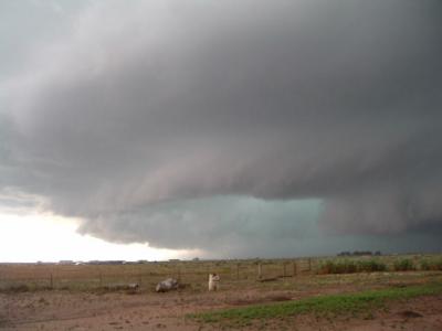
The blue-green color is an interesting issue. Here are a couple other (less dramatic) images of the same color under a thunderstorm.
http://charles-chandler.org/Geophysics/ ... rcell).jpg
http://charles-chandler.org/Geophysics/ ... rnado).jpg
The color has never been adequately explained. (There are theories, but they are all easily dismissed.) Here's my take:
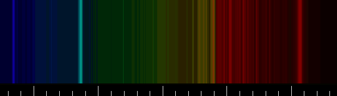
Studies have shown that while the precipitation that falls to the ground originates from a region in the cloud that is predominantly negative, outside of the cloud the precipitation has a predominantly positive charge. This means that something is stripping the electrons from the precipitation as it falls. What could do that? There's really only one possibility -- the precipitation would have to pass through positively-charged air, losing electrons in particle collisions. And when transferred, an electron is going to emit a photon when it enters into orbit around the destination. By the color of the photon, we can determine the nature of the destination. Of the molecules present, (N2, O2, and H2O), the blue-green color, with a wavelength of 486 nm, is an emission frequency only of water molecules.
http://charles-chandler.org/Geophysics/ ... 0Water.png
So we know from the color that positively-charged water molecules in the ambient air are picking up electrons from the negatively-charged rain.
The brilliance of the color in the image is very unusual, and perhaps is a result of the contrast enhancement that was applied.
beekeeper -- this is a one-of-a-kind photo. My guess is that this is a product of the long exposure time, plus some over-saturation. So it could have been a normal lightning strike, that branched into a tree-like structure entering the cloud, but what we're seeing is all of the branches smeared into a cone.
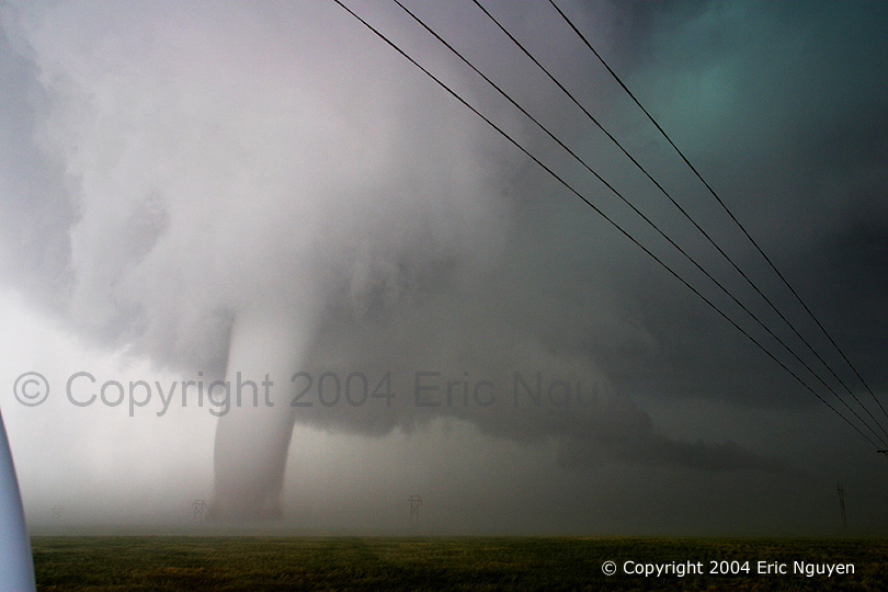
Yup. This is an extreme example, but not unknown. The bell-shaped cloud formation is called a shelf cloud, which surrounds a rain shaft. (The rain shaft is just a concentrated downpour in a relatively small area.) The website said that contrast enhancement was applied to the photo. I want to study it some more -- it looks like there are some artifacts from stitching together panoramic shots, but otherwise, it looks like an authentic image.601L1n9FR09 wrote:Is this an electric cloud or what?
First, the shelf cloud. Here's the standard explanation:
That sorta makes sense. But shelf clouds are a little too well organized for that to be a complete explanation. When a downdraft hits the ground, the outflow is turbulent, and turbulent flows are very irregular. So we'd expect the downdraft to produce a random assortment of puffy, cotton-ball clumps of condensation in the warm, moist ambient air that the downdraft is undercutting. We wouldn't expect a smooth, consistent wall of condensation wrapping around the rain shaft. Furthermore, shelf clouds often have horizontal striations, such as in this image on Wikipedia:Wikipedia wrote:Cool, sinking air from a storm cloud's downdraft spreads out across the surface with the leading edge called a gust front. This outflow undercuts warm air being drawn into the storm's updraft. As the cool air lifts the warm moist air, water condenses creating a cloud which often rolls with the different winds above and below (wind shear).
http://en.wikipedia.org/wiki/File:Rolli ... -cloud.jpg
There's just no way that these horizontal structures are the result of turbulent outflow elevating warm, moist ambient air.
In my opinion, this is an EM phenomenon. Rain is usually electrically charged. A huge mass of it falling out of the cloud will generate a magnetic field (by Ampere's Law). Since water molecules are diamagnetic, they align themselves in a magnetic field. And molecular alignment is one of the prerequisites for condensation. (The alignment means than in molecular collisions, multiple covalent bonds are formed, increasing the chance that the molecules will stick together.) So I agree with the consensus that that there is a body of warm, moist air around the rain shaft, that is getting undercut and elevated by the downdraft. This sets the stage for condensation. But what actually triggers the condensation is the magnetic force generated by the rain shaft, as this is the only force present with the form and the extents that match the actual condensation.
The blue-green color is an interesting issue. Here are a couple other (less dramatic) images of the same color under a thunderstorm.
http://charles-chandler.org/Geophysics/ ... rcell).jpg
http://charles-chandler.org/Geophysics/ ... rnado).jpg
The color has never been adequately explained. (There are theories, but they are all easily dismissed.) Here's my take:
Studies have shown that while the precipitation that falls to the ground originates from a region in the cloud that is predominantly negative, outside of the cloud the precipitation has a predominantly positive charge. This means that something is stripping the electrons from the precipitation as it falls. What could do that? There's really only one possibility -- the precipitation would have to pass through positively-charged air, losing electrons in particle collisions. And when transferred, an electron is going to emit a photon when it enters into orbit around the destination. By the color of the photon, we can determine the nature of the destination. Of the molecules present, (N2, O2, and H2O), the blue-green color, with a wavelength of 486 nm, is an emission frequency only of water molecules.
http://charles-chandler.org/Geophysics/ ... 0Water.png
So we know from the color that positively-charged water molecules in the ambient air are picking up electrons from the negatively-charged rain.
The brilliance of the color in the image is very unusual, and perhaps is a result of the contrast enhancement that was applied.
Give a man a fish and you feed him for a day. Teach a man to fish and he'll spend the rest of the day sitting in a small boat, drinking beer and telling dirty jokes.
Volcanoes
Astrophysics wants its physics back.
The Electromagnetic Nature of Tornadic Supercell Thunderstorms
Volcanoes
Astrophysics wants its physics back.
The Electromagnetic Nature of Tornadic Supercell Thunderstorms
-
jjohnson
- Posts: 1147
- Joined: Mon Feb 16, 2009 11:24 am
- Location: Thurston County WA
Re: Electric Clouds
Thanks, Charles. Re. The green color sometimes associated with thunderstorms. Part of the academic training of a military pilot is a course in aviation weather. It's pretty specific and pragmatic; not much theory to clutter up our focused little minds! Lapse rates, altimeter settings, cloud types, reading charts and progs and weather codes, etc.
Some time was spent discussing thunderstorms, as one is particularly interested in potentially lethal situations. Short of flying into terrain while in a cloud ("cumulo-granite" is the term in favor), a thunderstorm is a particularly dangerous weather phenomenon. We mostly learned avoidance - the cheap solution, but we also learned about how to penetrate a thunderstorm if it was absolutely necessary or too late, how to read them on radar, how to adjust airspeed for least stress from vertical shear, etc., and particularly to watch for greenish light in the vicinity of a growing or a mature anvil, or "thunderhead". The rationale for the green light was that it was caused by sunlight refracting through hail that was being ejected from near the top of the storm. I don't think, in retrospect, that any research had been done on the source of the color - it sounded plausible and gave a pilot one more cue as where not to fly, regardless of reason. Hail, of course, would make for a good reason. Flight through rocks is discouraged.
I like your explanation better, particularly for the near-ground and intra-cloud cases where there is little direct sunlight and the sheer vertical depth of cloud makes for a dark field against which a blue-greenish light emission would be more visible than against open sky. I have seen that light at altitude, but usually when it was near dusk, and the clouds were dark and back-lit. Not sure what's going on that high up (6-8 miles MSL).
Jim
-
mharratsc
- Posts: 1405
- Joined: Mon Jan 26, 2009 7:37 am
Re: Electric Clouds
Wow Frog, that is amazing! There's no way that the glow under that cloud is being caused by sunlight. That is one big plasma beam! 
Mike H.
"I have no fear to shout out my ignorance and let the Wise correct me, for every instance of such narrows the gulf between them and me." -- Michael A. Harrington
"I have no fear to shout out my ignorance and let the Wise correct me, for every instance of such narrows the gulf between them and me." -- Michael A. Harrington
-
CharlesChandler
- Posts: 1802
- Joined: Tue Aug 19, 2008 6:25 am
- Location: Baltimore, MD, USA
- Contact:
Re: Electric Clouds
This reminded me of an anecdote, which I tracked down and added to my website...jjohnson wrote:...least stress from vertical shear...
Here's my analysis.Another case comes from the "Thunderstorm Project" (1946-1949), in which pilots flew WWII fighters (P-61's) fitted with weather instruments into thunderstorms. One pilot reported that the interior of the storm suddenly changed from jet black to bright yellow, accompanied by constant electrical activity. At the same time, personnel on the ground observed a tornado descending from the wall cloud that had formed. When the pilot returned to base and the plane was inspected, it was found that rivet heads had been peeled off of the wings. Interestingly, the pilot did not report experiencing G forces sufficient to cause such damage.
The bright yellow color can only be reasonably explained as a glow discharge in highly-ionized air. Other reports of cavernous voids inside thunderstorms suggest that this was not a fluke, while the colors are more typically blue~green, which would be emissions from ionized nitrogen and/or water molecules. In the EMHD model, positive double-layers build up around recirculating negative charge streams. Being positively-charged, the water content will be entirely gaseous, explaining the emptiness in the middle of a storm. A positive double-layer on the inside of the recirculation could be especially charged, and could support a glow discharge between it and the negative charge stream around it. And flying through air with a strong positive charge could have resulted in rivet heads being weakened. Ionization loosens the covalent bonds that give solids their strength, hence positively-charged rivet heads might pop off even in conditions that were otherwise well within their rated strength. Later that evening at the nearest canteen, the pilot might have gotten toasted for being tough enough to pop rivets on a P-61 without passing out, but perhaps the storm electrification should have gotten the credit.
Little has been done to this day.jjohnson wrote:I don't think, in retrospect, that any research had been done on the source of the color.
That was probably just the sunlight filtering through the water vapor and/or ice crystals. You can see the same color, for the same reasons, in the winter, if you wait for a sunny day and then plunge a broom handle a couple of feet into a snow bank and then look in the hole. The blue-green color is light that fell elsewhere on the snow, and bounced around for a while inside the snow bank until finally illuminating the broom-stick hole. This is simply one of the emission frequencies of water molecules.jjohnson wrote:I have seen that light at altitude, but usually when it was near dusk, and the clouds were dark and back-lit. Not sure what's going on that high up (6-8 miles MSL).
Because of this, the various "explanations" of this color under a thunderstorm are all based on absorption/emission of sunlight, but this is hard to believe where the rest of the underside of the cloud is pitch black, as you said.
Give a man a fish and you feed him for a day. Teach a man to fish and he'll spend the rest of the day sitting in a small boat, drinking beer and telling dirty jokes.
Volcanoes
Astrophysics wants its physics back.
The Electromagnetic Nature of Tornadic Supercell Thunderstorms
Volcanoes
Astrophysics wants its physics back.
The Electromagnetic Nature of Tornadic Supercell Thunderstorms
-
mharratsc
- Posts: 1405
- Joined: Mon Jan 26, 2009 7:37 am
Re: Electric Clouds
Charles, you said that these voids inside these things are gaseous. Is it possible that perhaps these voids are areas that have had matter scavenged from them by Marklund convection going on in the very center of the cell? Couldn't that contribute to rain/hail formation in such tight areas in these storms?
I know I'm going off on tangents again, but consider that one shelf cloud picture with the high contrast. Why is it that these things show up with such a tight circular morphology so frequently? Why not just rain all over the damn place in chaotic patterns?
I know I'm quick to jump to conclusions, but I can't get the idea of a really low-density plasmoid/pinch out of my head in regards to some of this discussion. :\
Mike H.
"I have no fear to shout out my ignorance and let the Wise correct me, for every instance of such narrows the gulf between them and me." -- Michael A. Harrington
"I have no fear to shout out my ignorance and let the Wise correct me, for every instance of such narrows the gulf between them and me." -- Michael A. Harrington
-
CharlesChandler
- Posts: 1802
- Joined: Tue Aug 19, 2008 6:25 am
- Location: Baltimore, MD, USA
- Contact:
Re: Electric Clouds
Hey Mike,
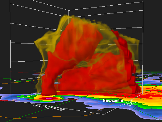
http://charles-chandler.org/Geophysics/ ... ivity).png
The hypothesis is that we don't get a radar echo from that area because it's a positive double-layer surrounding the negatively-charged precipitation (which does reflect), and positively-charged water particles break up into smaller pieces because they lack the electrons necessary for strong covalent bonds. Once they do, they don't reflect radar waves as well. This would also explain the rain-free "caverns" inside storms, as water particles broken down to the microscopic level are invisible.
If this is the case, we would just call it a positive double-layer. I "think" that Marklund convective is just another way of saying that in an electric field, particles get sorted on the basis of charge, and the sorting process can be considered to be a form of convection. So perhaps we're talking about the same thing.
The only hypothesis that couldn't be disproved one way or another is that the electric charges are lowering the viscosity of the air, which results in a fluid dynamic "channeling" effect. A lower viscosity fluid will tunnel through a higher viscosity fluid, as it experiences less friction, and therefore flows more freely. Charged gases have a lower viscosity, as electrostatic repulsion keeps everything going in the same direction, reducing friction. At the molecular level, if it was pure plasma (i.e., complete charge separation), you'd never get any particle collisions at all, as the electrostatic repulsion would keep the atoms from getting close enough to collide. With no particle collisions, you get zero friction, so pure plasma has no viscosity. At a larger scale, even if not all of the particles are charged, the ones that are charged provide a stabilizing force that helps prevent the conversion to turbulence, which would greatly slow down the flow. So I'm thinking that these structures are evidence of fluid dynamic channeling due to viscosity differences, which themselves are due to the presence of charged particles in the streams.
This could be the key to understanding lots of thunderstorm-related phenomena, such as rain/hail shafts, hook echoes, and downbursts. The significance of the last one is that it might be possible to detect downbursts on the basis of the magnetic fields that they (might) generate. Magnetometers are extremely sensitive and highly directional, so even if the field isn't strong enough to create a z-pinch, it might still be strong enough to lower the viscosity of the air, and to be detectable from a distance with a magnetometer. We know that downbursts can hit the ground (or an airplane) at nearly 80 m/s, when they shouldn't be able to exceed 40 m/s before getting randomized by turbulence. As the fluid dynamic principles in question are robust, there is no question that some other force is present, and the only other force present in the atmosphere is electromagnetism. So downbursts are an EM phenomenon. As such, they should be studied with EM instruments. It's possible that these are downdrafts that begin at the top of the storm, and that pick up speed as they fall, meaning that we might be able to detect these things several minutes in advance. Current technology (nose-cone Doppler radar) only gives pilots about 15 seconds of warning before a downburst hits, which isn't much time, and which also assumes that it's a wet downburst (which reflects radar beams). Dry downbursts are not detectable with any current technology. An airport equipped with an array of magnetometers feeding into a central server to triangulate the position, speed, and direction of moving electric charges in the storm, might be a lot cheaper and a lot more effective than nose-cone Doppler radar in detecting microbursts.
Pending the location of any data concerning where exactly these voids are occurring, my hunch is that they are between the updraft and the forward flank downdraft. In the following radar scan of a tornadic storm, you can clearly see the updraft on the left, and the forward flank downdraft feeding into the hook echo on the right. So I'm saying that the "void" is between these two.mharratsc wrote:Is it possible that perhaps these voids are areas that have had matter scavenged from them by Marklund convection going on in the very center of the cell?
http://charles-chandler.org/Geophysics/ ... ivity).png
The hypothesis is that we don't get a radar echo from that area because it's a positive double-layer surrounding the negatively-charged precipitation (which does reflect), and positively-charged water particles break up into smaller pieces because they lack the electrons necessary for strong covalent bonds. Once they do, they don't reflect radar waves as well. This would also explain the rain-free "caverns" inside storms, as water particles broken down to the microscopic level are invisible.
If this is the case, we would just call it a positive double-layer. I "think" that Marklund convective is just another way of saying that in an electric field, particles get sorted on the basis of charge, and the sorting process can be considered to be a form of convection. So perhaps we're talking about the same thing.
Excellent question! Such storms display a degree of organization that really can't be explained by fluid dynamic principles, and you're right -- all other factors being the same, there's no reason for rain to clump up the way it does. The only other possibility is that it's an EM phenomenon, but many people have told me that at the speeds in question (< 100 m/s), a magnetic field will definitely get generated, and it will be measurable, but it won't be powerful enough to exert any back-pressure on the charged particles (i.e., z-pinch). So what other EM property could cause this?mharratsc wrote:Why not just rain all over the damn place in chaotic patterns?
The only hypothesis that couldn't be disproved one way or another is that the electric charges are lowering the viscosity of the air, which results in a fluid dynamic "channeling" effect. A lower viscosity fluid will tunnel through a higher viscosity fluid, as it experiences less friction, and therefore flows more freely. Charged gases have a lower viscosity, as electrostatic repulsion keeps everything going in the same direction, reducing friction. At the molecular level, if it was pure plasma (i.e., complete charge separation), you'd never get any particle collisions at all, as the electrostatic repulsion would keep the atoms from getting close enough to collide. With no particle collisions, you get zero friction, so pure plasma has no viscosity. At a larger scale, even if not all of the particles are charged, the ones that are charged provide a stabilizing force that helps prevent the conversion to turbulence, which would greatly slow down the flow. So I'm thinking that these structures are evidence of fluid dynamic channeling due to viscosity differences, which themselves are due to the presence of charged particles in the streams.
This could be the key to understanding lots of thunderstorm-related phenomena, such as rain/hail shafts, hook echoes, and downbursts. The significance of the last one is that it might be possible to detect downbursts on the basis of the magnetic fields that they (might) generate. Magnetometers are extremely sensitive and highly directional, so even if the field isn't strong enough to create a z-pinch, it might still be strong enough to lower the viscosity of the air, and to be detectable from a distance with a magnetometer. We know that downbursts can hit the ground (or an airplane) at nearly 80 m/s, when they shouldn't be able to exceed 40 m/s before getting randomized by turbulence. As the fluid dynamic principles in question are robust, there is no question that some other force is present, and the only other force present in the atmosphere is electromagnetism. So downbursts are an EM phenomenon. As such, they should be studied with EM instruments. It's possible that these are downdrafts that begin at the top of the storm, and that pick up speed as they fall, meaning that we might be able to detect these things several minutes in advance. Current technology (nose-cone Doppler radar) only gives pilots about 15 seconds of warning before a downburst hits, which isn't much time, and which also assumes that it's a wet downburst (which reflects radar beams). Dry downbursts are not detectable with any current technology. An airport equipped with an array of magnetometers feeding into a central server to triangulate the position, speed, and direction of moving electric charges in the storm, might be a lot cheaper and a lot more effective than nose-cone Doppler radar in detecting microbursts.
Give a man a fish and you feed him for a day. Teach a man to fish and he'll spend the rest of the day sitting in a small boat, drinking beer and telling dirty jokes.
Volcanoes
Astrophysics wants its physics back.
The Electromagnetic Nature of Tornadic Supercell Thunderstorms
Volcanoes
Astrophysics wants its physics back.
The Electromagnetic Nature of Tornadic Supercell Thunderstorms
-
Osmosis
- Posts: 423
- Joined: Wed Mar 19, 2008 3:52 pm
- Location: San Jose, California
Re: Electric Clouds
Hi Charles-
I mentioned magnetometer arrays in tornado country, some time ago. I was just thinking-if this sort of array was installed, the maggies should be buried in the ground, so they are not subject to damage. Also, would total-field mags be better than vector mags, for this application?
Best regards,
Osmosis
-
jjohnson
- Posts: 1147
- Joined: Mon Feb 16, 2009 11:24 am
- Location: Thurston County WA
Re: Electric Clouds
Hi, Charles,
Another, simpler explanation for popping rivets in the P-51 example is extreme bending of the metal skin of an aircraft. I have observed a T-38 that was momentarily overstressed by a student pilot (to about 11.5 g's, probably for less than a second). Military fighter aircraft are normally rated for 8 g's or thereabouts because it is impractical for pilots, physiologically, to attempt to pull more than that.
The wings were curved slightly up because the g-load had bent the spars, and rivets had departed large areas of the lower fuselage panels. The wings were replaced, and the fuselage area rebuilt, and the aircraft was returned to service. Lucky pilot; cheated death again.
G-loads due to wind shear inside a thunderstorm is one primary reason for avoidance, one is taught. We slow down to a moderate speed to minimize such loads, if actually caught in such conditions, and use the radar to find the earliest feasible exit. It is possible to exceed the structural design limits of an aircraft in a thunderstorm, including popping rivets, delamination, and failure of primary structures like wing spars and fuselage longerons.
Jim
Jim
-
Dotini
- Posts: 315
- Joined: Wed Mar 10, 2010 7:44 am
- Location: Seattle
-
CharlesChandler
- Posts: 1802
- Joined: Tue Aug 19, 2008 6:25 am
- Location: Baltimore, MD, USA
- Contact:
Re: Electric Clouds
The total field would give a better idea of the overall EM organization of the storm. In my opinion, this might be useful for predicting tornadoes. Once a tornado touches down, verifying that there is, indeed, a tornado on the ground, and pinpointing the location, would take vector mags. So the answer is both!Osmosis wrote:Would total-field mags be better than vector mags, for this application?
This is So Cool -- great scoop, Steve!Dotini wrote:An odd cloud gets stuck in a fence!
There are some keys pieces missing, which prevent a conclusive analysis. For example, we don't know for sure that this "cloud" is water condensation. I'm willing to go on the assumption that it is. If so, this video gives us tons of information about the possible properties of water.
So what do we observe?
- This occurred in an arid climate, where the only way to get vegetation to grow is to irrigate. So we can expect the air to be dry, except for whatever moisture is evaporating from the irrigated sand.
- A puff of [what I assume to be] water condensation is moving along, about 10 meters above the ground, in a light breeze.
- There is a sand road with chain-link fences on both sides.
- When the condensation gets over the road, it stops moving along, and rather, starts spinning and tumbling.
- The condensation then swoops done to the road and accelerates up against the fence, leaving several softball-sized clumps of condensation stuck to the middle of the road. Some of the condensation passes through the fence, but doesn't go far, clinging to the ground and/or the other side of the fence.
- Once attached to the fence, the condensation morphs into a nearly cylindrical form. Then it suddenly stands up and becomes perfectly cylindrical as it rolls down the fence.
- A portion of the cylinder passes through the fence, forming a sheet of condensation waving in the breeze.
- The person sticks his hand into it, and then realizes that it has a high viscosity, which he plays with, forming a hole. It's so "sticky" that he flicks his fingers to remove any remaining goo when he pulls his hand out.
- Several seconds later, the hole in the goo is still there, as the video zooms in, and we can see through the hole to the chain-link fence.
- Water aerosols in a cloud do not typically have an increased viscosity that would make it gooey. This means that there was something different about this clump. The only possible difference is that this clump was electrically-charged. If so, when exposed to an opposite charge, it will be attracted to that charge. The electric field between the two will then polarize the dipolar water molecules, and these will organize into polymer strands. As such, the condensation will then have more viscosity, and might even display a little bit of tensile strength, as did the "sheets" of condensation waving in the breeze.
- The charge separation mechanism under these conditions would be ionization from sunlight. When absorbing a photon, molecules in the sand can liberate electrons. Some of these can get captured by water molecules in the air, which are better at hosting excess electrons than nitrogen or oxygen. This will leave the sand positively-charged, and the water molecules negatively-charged. As such, there will be an electric field between the water molecules and the sand, and the attractive force will keep the water nearby. So we can expect a strong humidity gradient near the ground, with bone-dry air above.
- Water molecules have another important property that we should take into account. Unlike molecular nitrogen and oxygen, water molecules can absorb and re-radiate infrared waves, meaning that they will also be heated by the sand (even without being in direct contact with it), creating buoyancy in the atmosphere. If the buoyancy overpowers the electric field, the moist parcel will rise.
- It's possible that what we're seeing is a moist, negatively-charged parcel of air that rose because of its heat, to an altitude (~10 meters) at which the water vapor condensed. When it passed over the road, the extra positive charge in the fully-exposed sand exerted a force capable of pulling the parcel down to the ground. It then experienced an even stronger attraction to the fence, so we'll guess that the fence was ionized also, and that it wasn't grounded, or it wouldn't have supported a net positive charge.
Give a man a fish and you feed him for a day. Teach a man to fish and he'll spend the rest of the day sitting in a small boat, drinking beer and telling dirty jokes.
Volcanoes
Astrophysics wants its physics back.
The Electromagnetic Nature of Tornadic Supercell Thunderstorms
Volcanoes
Astrophysics wants its physics back.
The Electromagnetic Nature of Tornadic Supercell Thunderstorms
-
webolife

- Posts: 2539
- Joined: Mon Mar 17, 2008 2:01 pm
- Location: Seattle
Re: Electric Clouds
WHAAA... 
All I see is a pile of suds picked up from some pool or bath nearby by a gust of wind...
All I see is a pile of suds picked up from some pool or bath nearby by a gust of wind...
Truth extends beyond the border of self-limiting science. Free discourse among opposing viewpoints draws the open-minded away from the darkness of inevitable bias and nearer to the light of universal reality.
-
CharlesChandler
- Posts: 1802
- Joined: Tue Aug 19, 2008 6:25 am
- Location: Baltimore, MD, USA
- Contact:
Re: Electric Clouds
How are you going to explain that quantity of soap suds in the United Arab Emirates?webolife wrote:All I see is a pile of suds...
Give a man a fish and you feed him for a day. Teach a man to fish and he'll spend the rest of the day sitting in a small boat, drinking beer and telling dirty jokes.
Volcanoes
Astrophysics wants its physics back.
The Electromagnetic Nature of Tornadic Supercell Thunderstorms
Volcanoes
Astrophysics wants its physics back.
The Electromagnetic Nature of Tornadic Supercell Thunderstorms
-
Dotini
- Posts: 315
- Joined: Wed Mar 10, 2010 7:44 am
- Location: Seattle
Re: Electric Clouds
It cannot yet be ruled out that, due to the proximity of UAE to the Persian Gulf, it may be only sea foam that we are seeing.
http://www.youtube.com/watch?v=k7dfiAgTbkg
http://www.youtube.com/watch?v=6AfwLozBGfU
Respectfully submitted with a tip of the hat to our friend Tim,
Steve
http://www.youtube.com/watch?v=k7dfiAgTbkg
http://www.youtube.com/watch?v=6AfwLozBGfU
Respectfully submitted with a tip of the hat to our friend Tim,
Steve
-
CharlesChandler
- Posts: 1802
- Joined: Tue Aug 19, 2008 6:25 am
- Location: Baltimore, MD, USA
- Contact:
Re: Electric Clouds
1) Is sea foam capable of such buoyancy? In the videos, it was getting blown around, but I didn't see any big blobs of it at 10 meters off the ground, moving at a couple of meters per second with the light breeze.Dotini wrote:It may be only sea foam...
2) Wouldn't sea foam have stuck to the guy's hand, as would any surfactant?
Just guesswork, but this is why I went ahead and did an analysis based on the assumption that it was water condensation.
Give a man a fish and you feed him for a day. Teach a man to fish and he'll spend the rest of the day sitting in a small boat, drinking beer and telling dirty jokes.
Volcanoes
Astrophysics wants its physics back.
The Electromagnetic Nature of Tornadic Supercell Thunderstorms
Volcanoes
Astrophysics wants its physics back.
The Electromagnetic Nature of Tornadic Supercell Thunderstorms
Who is online
Users browsing this forum: No registered users and 58 guests