Earth's Surface Formed Recently

Historic planetary instability and catastrophe. Evidence for electrical scarring on planets and moons. Electrical events in today's solar system. Electric Earth.

Moderators: MGmirkin, bboyer

Locked
Lloyd
Posts: 4433
Joined: Fri Apr 04, 2008 2:54 pm

Re: Earth's Surface Formed Recently

Unread post by Lloyd » Thu Jul 05, 2012 5:09 pm

Jone said in reply to Sparky: I haven't found De Grazia's work speculative in general; I believe that you are mistaken there, although, of course, he does speculate sometimes in his writings. Any other reactions?
* I posted my reaction right after Sparky's above at http://thunderbolts.info/wp/forum/phpBB3/v ... 135#p67472.
* I favor Cardona's theory over de Grazia's so far, because I've read one of his books and a lot of his former magazine articles, which seem to show good evidence and reasoning for his Saturn theory etc. The Solar System was a binary system when Saturn first arrived as a brown dwarf star, but Saturn soon lost much of its mass when it flared about 10,000 years ago.
* How long have you been following EU theory or Catastrophism?

Lloyd
Posts: 4433
Joined: Fri Apr 04, 2008 2:54 pm

Re: Earth's Surface Formed Recently

Unread post by Lloyd » Mon Aug 13, 2012 11:52 am

Giant Meteorites Slammed Earth Around A.D. 500?
http://news.nationalgeographic.com/news ... l-cooling/
* I saw a satellite tv show last night about this and related topics. I guess it was on the National Geographic channel.
* It looks like a number of geologists and other scientists are coming around to the idea of recent catastrophes on Earth. The majority seem to be still very skeptical of this view, but the evidence is getting so obvious that it seems that the more open-minded are beginning to accept the inevitable, while the majority still fear to join the camp of the "crackpot" catastrophist crowd, thanks to the mainstream's former close encounter with Velikovsky in their kangaroo court at the 1974 AAAS symposium etc.
3 Recent Catastrophes
* The 536 AD catastrophe was said to have occurred after a comet strike in the Gulf of Carpentaria in Australia. They think it may have led to the Dark Ages in Europe. There were crop failures due to global cooling from 536 to 545 AD, so the impact is thought to have raised a large amount of dust into the atmosphere. They're even using Aboriginal folk stories to help find impact craters etc. So this is paving the way for accepting other ancient myths as evidence for other ancient catastrophes.
* Others are working on the theory that a comet or asteroid impacted in Italy in 312 AD, which looked like the sign of the cross, which Roman emperor Constantine saw as a sign by which to conquer his enemies.
* The third recent catastrophe isn't so recent, but it's within the time of ancient man and civilization. This time a comet or asteroid is thought to have hit the ice sheet in North America, or to have exploded in the air, and destroyed megafauna and the Clovis civilization about 13,000 years ago. They think the sea level was quite a bit lower and the Clovis people may have come from Europe by following the edges of the ice sheet in the north Atlantic, where there were also islands that are now submerged.
* The scientists working on this last theory are called the Holocene Impact Working Group. Wikipedia mentions this group, but only gives evidence from its opponents, rather than showing what the group's evidence is. It mentions for example that the group theorizes that chevron formations on coastlines or former coastlines indicate where megatsunamis struck. The tv show last night mentioned opponents' views on chevrons, but then showed the group's evidence, which was much better. The group thinks catastrophic impacts occur about every thousand years and one of them occurred 5,000 years ago in the Indian Ocean. Chevrons were found in Madagascar, which point backwards to Burckle Crater in mid ocean. Within the chevron formation, which is mounded up into a hill, were found many fossils from creatures that come from the Indian Ocean floor, not from the ocean surface, which hurricanes would bring ashore. The double crater in northeastern Australia's Gulf of Carpentaria were also found from chevron locations on the beach there. They pointed to 2 craters very close to shore [one is about 5 miles out, adjacent to an island; the other is 30 or 40 miles out]. An article, titled Did an asteroid strike in Australia plunge Anglo-Saxon England into a mini ice-age?, at http://www.dailymail.co.uk/sciencetech/ ... e-age.html discusses this.
* Dennis Cox, one of our former forum members, has done a lot of work along those lines too. His descriptions of the catastrophes of 13,000 or so years ago is more exciting than most. He talks about a heat and pressure blast that lasted for an hour or so, and killed most everything in North America. See https://www.google.com/search?q=site%3A ... nis+cox%22. Rick Firestone has related ideas. See https://www.google.com/search?q=site%3A ... restone%22.

Lloyd
Posts: 4433
Joined: Fri Apr 04, 2008 2:54 pm

Re: Earth's Surface Formed Recently

Unread post by Lloyd » Mon Aug 13, 2012 3:51 pm

IMPACT CRATERS AS SOURCES OF MEGATSUNAMI GENERATED CHEVRON DUNES
https://gsa.confex.com/gsa/2006AM/final ... 114274.htm
2006 Philadelphia Annual Meeting (22–25 October 2006)
Paper No. 119-20
Presentation Time: 1:30 PM-5:30 PM
ABBOTT, Dallas H.1, MARTOS, Suzanne1, ELKINTON, Hannah1, BRYANT, Edward F.2, GUSIAKOV, Viacheslav3, and BREGER, Dee4, (1) Lamont Doherty Earth Observatory of Columbia University, Oceanography 103A, 1000 Rt. 9W, Palisades, NY 10964, dallas@ldeo.columbia.edu, (2) School of Geosciences, University of Wollongong, Wollongong, NSW 2522, Australia, (3) Tsunami Laboratory, Institute of Computational Mathematics and Mathematical Geophysics, Novosibirsk, 630090, Russia, (4) Dept. of Materials Science, Drexel University, 3141 Chestnut Street, Philadelphia, PA 19104
- Chevron dunes are not formed by wind. Chevron dunes are not oriented in the direction of the prevailing wind, they can form where there are no beaches, and they contain grains larger than 2 mm in diameter. Chevrons are produced by megatsunamis originating from point sources, i.e. landslides, impact craters, and volcanic explosions.
- We have assembled data on chevrons worldwide. Most are best explained as the result of tsunami generated from large impact cratering events. We now have data confirming an impact origin of two chevron sources.
- In the Indian ocean, chevron dunes in Western Australia, India, and Madagascar point towards the 29 km Burckle Crater at 30.865S, 61.365E. The impact ejecta from Burckle crater contain meteorite fragments, impact glass, oceanic mantle fragments, and impact spherules. The impact spherules are >200 microns in diameter, consistent with a 29 km crater. The impact glasses have no K and cannot be continental in origin.
- In the Gulf of Carpentaria [NE Australia], we found impact ejecta that contain impact glass and meteoritic material: merrillite, high Ni metal, and probable melted carbonaceous chondrite [1]. We also found abundant magnetite impact spherules with a bimodal size distribution [2]. This implies two source craters for the chevrons: the 18 km Kanmare (Serpent) crater at 16.58S, 139.057E and the 12 km Tabban (Rainbow) crater at 17.125S, 139.86E.
- In the Mediterranean, a megatsunami source near the Rhone delta is of undetermined origin. All other sources are impact crater candidates and require more study. We found the following: the 1 km Judge crater candidate in Long Island Sound at 41.17N, 72.405W, the 10 km Quetzalcoatl crater candidate in the Caribbean at 22.04N, 96.32W, the 18 km Grendel crater candidate in the North Sea at 58.16 N, 5.86E, the 5 km Kangaroo crater candidate at 39.0465S, 141.285E and the 4 km Joey crater candidate at 39.16S, 141.21E.

- [1].Elkinton et al., 2006-this volume. [2] Martos et al., 2006-this volume
2006 Philadelphia Annual Meeting (22–25 October 2006)
General Information for this Meeting
Session No. 119
Impact Craters: Structures, Drilling, Ages, and Geophysics (Posters)
Pennsylvania Convention Center: Exhibit Hall C
1:30 PM-5:30 PM, Monday, 23 October 2006
- Geological Society of America Abstracts with Programs, Vol. 38, No. 7, p. 299
seasmith
Posts: 2815
Joined: Thu Mar 27, 2008 6:59 pm

Re: Earth's Surface Formed Recently

Unread post by seasmith » Wed Aug 15, 2012 6:20 pm

Image


Coming soon:
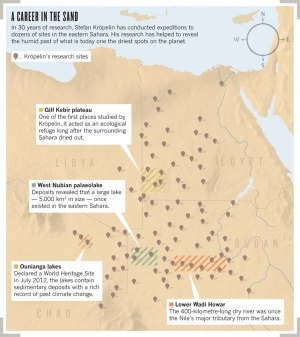
A 12,000 year empirical History of the Sahara


http://www.nature.com/news/science-in-t ... rt-1.11162


[here is a dedicated researcher]

Sparky
Posts: 3517
Joined: Tue Jul 20, 2010 2:20 pm

Re: Earth's Surface Formed Recently

Unread post by Sparky » Thu Aug 16, 2012 8:38 am

Image

what's an east way to magnify this?.. :oops: .thanks
"It is dangerous to be right in matters where established men are wrong."
"Doubt is not an agreeable condition, but certainty is an absurd one."
"Those who can make you believe absurdities, can make you commit atrocities." Voltaire

User avatar
nick c
Site Admin
Posts: 2483
Joined: Sun Mar 16, 2008 8:12 pm
Location: connecticut

Re: Earth's Surface Formed Recently

Unread post by nick c » Thu Aug 16, 2012 9:09 am

Sparky wrote:
Sahara_map.jpg
what's an east way to magnify this?.. .thanks
Sparky,
Go to seasmith's link:
http://www.nature.com/news/science-in-t ... rt-1.11162
Click on the Sahara map in the article and it will be enlarged.

Sparky
Posts: 3517
Joined: Tue Jul 20, 2010 2:20 pm

Re: Earth's Surface Formed Recently

Unread post by Sparky » Thu Aug 16, 2012 1:39 pm

That worked! Thanks ;)
"It is dangerous to be right in matters where established men are wrong."
"Doubt is not an agreeable condition, but certainty is an absurd one."
"Those who can make you believe absurdities, can make you commit atrocities." Voltaire

Lloyd
Posts: 4433
Joined: Fri Apr 04, 2008 2:54 pm

Re: Earth's Surface Formed Recently

Unread post by Lloyd » Fri Aug 17, 2012 1:35 pm

Sahara Strata
* Speaking of the Egyptian Sahara, in the Ice Ages thread I recently posted here http://www.thunderbolts.info/wp/forum/phpB ... =45#p69171 to mention that some scientist said sandstone underlies the Sahara, so I suggested that much of the sand of the Sahara seems likely to have eroded from the underlying sandstone, by wind, rain, frost etc. The sandstone is said to be in the tens of millions of years old, whereas the Sahara desert is said to be maybe 6,000 years old. Of course, we don't accept much of conventional dating and Cardona theorizes that much of the rock strata came from Saturn flares 10,000 or more years ago. I read before of evidence of a former large lake in the north central Sahara thousands of years ago, which somehow drained and left behind much sand. I read that something like 28% of the Sahara is sand-covered, while the rest is barren rock.
Egypt Cross Section
* I just found geological cross sections of 4 temporary lakes in southern Egypt, shown in this image, http://geosphere.gsapubs.org/content/4/ ... .large.jpg, which apparently come from an article at this link, http://geosphere.gsapubs.org/content/4/2/375.abstract. The cross sections show the following layers in descending order:
5. a 60-90m layer of Eocene limestone, over 70% eroded away
4. a 60-90m layer of Paleocene shale and chalk, about 30% eroded away
3. a 10-20m layer of Upper Cretaceous sandstone and limestone
2. a 60m layer of Cretaceous sandstone
1. a layer of Neoproterozoic granitoids of undisclosed depth
Erosion to Sand
* The wind blows mostly from west to east there, so Egypt is covered by sand from the west, I think. I wonder if the sands are all moving eastward. If so, it could be predicted how long it will take for the sand to leave Libya and nearby areas and how long ago it started and where.
* To prove my idea about the sand having eroded from sandstone, would layers of sandstone need to be found on the surface somewhere that's eroded? The layer number 3 above is slightly eroded under one or two of the temporary lakes. Sand can also come from other rocks, like shale. What about limestone?
* I'm mostly just thinking out loud here for now.

User avatar
GaryN
Posts: 2668
Joined: Tue Apr 01, 2008 8:18 pm
Location: Sooke, BC, Canada

Re: Earth's Surface Formed Recently

Unread post by GaryN » Sat Aug 18, 2012 11:24 am

An interesting presentation, I thought: Ideas, a CBC Canada radio show ran this program last year, but I only recently listened to it. "Bones of the Earth" talks about Gros Morne National Park, Newfoundland, and how they think it was formed, and the 'discovery' of the idea of plate techtonics. Millions and billions of years again, for what may have been a much more recent event or events, and have involved energies from above and not deep below.
In western Newfoundland, there's a national park that holds the key to one of the most important scientific ideas of our times: plate tectonics.
Image
http://www.cbc.ca/ideas/episodes/2011/0 ... the-earth/
The Audio(53 mins.):
http://www.cbc.ca/ideas/episodes/2011/0 ... l?cs=utf-8#
In order to change an existing paradigm you do not struggle to try and change the problematic model. You create a new model and make the old one obsolete. -Buckminster Fuller

User avatar
GaryN
Posts: 2668
Joined: Tue Apr 01, 2008 8:18 pm
Location: Sooke, BC, Canada

Re: Earth's Surface Formed Recently

Unread post by GaryN » Wed Aug 22, 2012 10:31 am

Maybe nobody has listened to the show, or perhaps everyone agrees with the plate techtonics model, but I have to say I thought the show shocking. It was a quasi-religious, romanticised, unprovable load of claptrap. The constant repetition of "500 million years", and "time,lots of time" as the mechanism of formation sounded like an attempt at total brainwashing of the audience. It should have had an "R" rating, not fit to be heard by young, impressionable minds. I'd think it only fair that the CBC should have pointed out the unknowns and uncertainties of the standard model, rather than keep using "500 million years" to smooth over the cracks.
I have noticed though that one or two geologists have mentioned the often puzzling nature of the geological column, and in this paper about the Closepet granite of southern India, the author mentions the same obervations.
Some problems, however, remain to be assessed regarding the origin of the Closepet Granite. One is the problem of the size: even if the processes operating are the same all along the Closepet Granite, such a huge body probably needs several feeding zones, or even a continuous band of magma input zones, even if the subsequent evolution is similar all along the granite. A second question is the unique nature of the Closepet granite within the Dharwar craton: even if granitic bodies are common in the area(Drury and Holt, 1980; Krogstad et al., 1991;Chadwick et al., 1996), none of them reachesthe same size, nor displays the same degree of crust-mantle interaction. The source of both the large quantity of observed magma,and the considerable amount of heat needed remains unknown. This calls for furtherinvestigations on the geodynamical setting and evolution of the Late Archaean Dharwar Craton
http://univ-st-etienne.academia.edu/Jea ... outh_India

The granite must be coming from below, but we don't know where. The nature of the crust-mantle interaction. If the heat source were from above, would't that provide a simple answer? This could also be the case at Gros Morne, and many other sites where there are questions about the origins of some formations. Very unlikely they will ever even consider such a possibility, the standard model of geology would be toast, and the Electric Universe, despite the implied, downright scary magnitude of such events, might be the only possible alternative.
In order to change an existing paradigm you do not struggle to try and change the problematic model. You create a new model and make the old one obsolete. -Buckminster Fuller

User avatar
webolife
Posts: 2539
Joined: Mon Mar 17, 2008 2:01 pm
Location: Seattle

Re: Earth's Surface Formed Recently

Unread post by webolife » Fri Aug 31, 2012 7:52 am

Lloyd wrote:Sahara Strata
* Speaking of the Egyptian Sahara, in the Ice Ages thread I recently posted here http://www.thunderbolts.info/wp/forum/phpB ... =45#p69171 to mention that some scientist said sandstone underlies the Sahara, so I suggested that much of the sand of the Sahara seems likely to have eroded from the underlying sandstone, by wind, rain, frost etc. The sandstone is said to be in the tens of millions of years old, whereas the Sahara desert is said to be maybe 6,000 years old. Of course, we don't accept much of conventional dating and Cardona theorizes that much of the rock strata came from Saturn flares 10,000 or more years ago. I read before of evidence of a former large lake in the north central Sahara thousands of years ago, which somehow drained and left behind much sand. I read that something like 28% of the Sahara is sand-covered, while the rest is barren rock.
Egypt Cross Section
* I just found geological cross sections of 4 temporary lakes in southern Egypt, shown in this image, http://geosphere.gsapubs.org/content/4/ ... .large.jpg, which apparently come from an article at this link, http://geosphere.gsapubs.org/content/4/2/375.abstract. The cross sections show the following layers in descending order:
5. a 60-90m layer of Eocene limestone, over 70% eroded away
4. a 60-90m layer of Paleocene shale and chalk, about 30% eroded away
3. a 10-20m layer of Upper Cretaceous sandstone and limestone
2. a 60m layer of Cretaceous sandstone
1. a layer of Neoproterozoic granitoids of undisclosed depth
Erosion to Sand
* The wind blows mostly from west to east there, so Egypt is covered by sand from the west, I think. I wonder if the sands are all moving eastward. If so, it could be predicted how long it will take for the sand to leave Libya and nearby areas and how long ago it started and where.
* To prove my idea about the sand having eroded from sandstone, would layers of sandstone need to be found on the surface somewhere that's eroded? The layer number 3 above is slightly eroded under one or two of the temporary lakes. Sand can also come from other rocks, like shale. What about limestone?
* I'm mostly just thinking out loud here for now.
Some reflections about deserts, dunes and underlying rock:
1. It is possible for at least some of the underlying sandstone to form after the sand, as is the case in some places in the southwest US. A couple decades ago I stopped at Coral Pink Sand dunes in Utah for a travel break with my family. My kids went running off into the dunes to play and were digging holes when about 6 inches down my son struck rock. Curious about this I went over and brushed away a large spot of the overlying dune to find that recent rains had compacted underlying materials into very hard material. Investigating further around some road cuts in the park I found that this material could be seen to grade directly into classic cemented sandstone at depths of only several feet. Apparently, the silicates and limes of the overblown material combined with rainwater seeping down through the drifting sand above formed sandstone beneath.
2. The Sahara winds blow eastward in the east, southward in the south, and westward in the west, expanding the Sahara "radially" at a remarkable rate of as many as 8 km per year in some areas. This has thwarted efforts over many decades to reclaim arable lands in several of the central African countries, eg. Chad. It is interesting to me to turn back the Sahara growth clock to a time not too distant when there was no desert.
3. Obviously[?], sandstone itself comes from slurries of eroded sand carried by water or wind during past times of great flooding, and subsequent weathering and erosion blows it back into dunes, so the rock to sand to rock process is cyclic.
4. Limestone, an important cementing agent, is very interesting in that it can be found atop or interbedded with pretty much any other kind of rock formation, with the possible exception of "geologically recent" volcanics. In
Washington, our Cascade mountain range is topped with it. Several layers in the Grand Canyon, and thousands of meters of it in the Rockies. Huge caverns hewn out of it in many states and countries. Much of Europe sits on it, and many important fossil graveyards have been found it in. This speaks volumes to me about the cataclysmic watery history of our planet's surface.
Truth extends beyond the border of self-limiting science. Free discourse among opposing viewpoints draws the open-minded away from the darkness of inevitable bias and nearer to the light of universal reality.

madkevo
Posts: 22
Joined: Mon Sep 10, 2012 2:01 am

clay formation

Unread post by madkevo » Mon Sep 10, 2012 2:05 am

Seems that clay formation may not require oceans of water, but as a main requiremet some extreme heat - maybe some (short-lived?) high energy input. Looking forward to hearing some views from you all!
http://www.bbc.co.uk/news/science-environment-19525421

User avatar
tayga
Posts: 668
Joined: Wed Nov 19, 2008 7:54 am

Re: clay formation

Unread post by tayga » Mon Sep 10, 2012 3:33 pm

The formation still requires water content in the rock, though ;)
tayga


It doesn't matter how beautiful your theory is, it doesn't matter how smart you are. If it doesn't agree with experiment, it's wrong.

- Richard P. Feynman

Normal science does not aim at novelties of fact or theory and, when successful, finds none.
- Thomas Kuhn

User avatar
starbiter
Posts: 1445
Joined: Mon Mar 17, 2008 9:11 am
Location: Antelope CA
Contact:

Re: clay formation

Unread post by starbiter » Mon Sep 10, 2012 4:05 pm

Mars and Venus are claimed to have had 4 encounters during the time of Isaiah. Venus was still a comet i believe. Or it had recently been a comet. Comet comas have clay.

http://www.nasa.gov/mission_pages/deepi ... 90705.html

[...]

These solid ingredients include many standard comet components, such as silicates, or sand. And like any good recipe, there are also surprise ingredients, such as clay and chemicals in seashells called carbonates. These compounds were unexpected because they are thought to require liquid water to form.

Me again,

Comets are convenient for supplying everything required for the surface of Earth to quite a depth. Rare earths, hydrocarbons, carbonates, pyroxene, olivine, carbide, and of course clay.

michael
I Ching #49 The Image
Fire in the lake: the image of REVOLUTION
Thus the superior man
Sets the calender in order
And makes the seasons clear

www.EU-geology.com

http://www.michaelsteinbacher.com

Lloyd
Posts: 4433
Joined: Fri Apr 04, 2008 2:54 pm

Re: clay formation

Unread post by Lloyd » Mon Sep 10, 2012 8:35 pm

Michael said: Comets are convenient for supplying everything required for the surface of Earth to quite a depth. Rare earths, hydrocarbons, carbonates, pyroxene, olivine, carbide, and of course clay.
* Then do you deny the Saturn Theory and detritus from periodic ancient Saturn flares?
* The volume of all former comets is likely to be quite small. The volume of Saturn in ancient times may have been greater than Jupiter. The source of all comets and asteroids may be Saturn too.

Locked

Who is online

Users browsing this forum: No registered users and 24 guests