Hello again Julian: People come from around the world to climb the sandstone in Red Rock Canyon, and the Moab area. The sandstone is so hard that anchors don't pull out of the rock. If the anchor does pull out the climber has a high probability of death. The best way to describe the density is to compare it to steel. While preparing small pieces of stone for zapping it required days of sawing with a sharp hacksaw.
There are other areas where sand sluffs of the rocks easily. Maroon Bells in Colorado is an example. Climbers are warned not to scale the Bells. Search and rescue need to remove bodies on a regular basis. Just prior to my visit someone died. The same with Mt. Charelston, West of Vegas. The top of the mountain is a form of conglomerate. Sand that has solidified, with stones of varying size cemented inside. Climbers beware. These rocks seem hard enough, but compared to the climbing rocks they are soft.
The tailings you mention might not be good for climbing, even though they resist a pick. I think it's this extraordinary hardness that causes the experts to propose the burying of the dunes with miles of cover. Also, the chemistry seems to require leaching of minerals into the dune. This requires dirt with diferent chemistry to leach new elements into the dune. Of course, i think plasma caused the conversion to rock, and the comet provided the missing elements.
The Great Sand Dune National Monument is sand all the way to the bottom [no rock], according to the park geologists. And it's wet all the way to the bottom. They claim it's 180,000 years old . I propose the zapping had ended prior to the formation.
I hope this helps your understanding.
michael steinbacher
Rock Strata Formation
-
starbiter

- Posts: 1445
- Joined: Mon Mar 17, 2008 9:11 am
- Location: Antelope CA
- Contact:
Re: Rock Strata Formation
I Ching #49 The Image
Fire in the lake: the image of REVOLUTION
Thus the superior man
Sets the calender in order
And makes the seasons clear
www.EU-geology.com
http://www.michaelsteinbacher.com
Fire in the lake: the image of REVOLUTION
Thus the superior man
Sets the calender in order
And makes the seasons clear
www.EU-geology.com
http://www.michaelsteinbacher.com
-
Lloyd
- Posts: 4433
- Joined: Fri Apr 04, 2008 2:54 pm
Re: Rock Strata Formation
* You seem to want to call everything dunes, but dunes are simply piles of windblown sand. And sand only constitutes 20-25% of sedimentary rock. 65% is shale. Sand that wasn't blown by wind into hills or ridges was never a dunefield, such as beach sand at or below the shoreline, or sand that was laid down by the Great Flood in strata.
http://www.answers.com/topic/dune
* Here's beach sand on the left and dune sand on the right under a microscope:
* So one can tell apparently from the shape of the sand in sandstone, whether it was dune sand or not. Also, if sandstone is found to be dune shaped, I guess it was probably dune sand. Right?
http://www.answers.com/topic/dune
* Here's sandstone under a microscope:- A dune is a hill or ridge of wind-blown sand.
- It's a mobile accumulation of sand-sized material that occurs along shorelines and in deserts because of wind action. Dunes are typically located in areas where winds decelerate and undergo decreases in sand-carrying capacity. Dunefields are composed of rhythmically spaced mounds of sand that range from about 3 ft (1 m) to more than 650 ft (200 m) in height and may be spaced as much as 5000 ft (1.5 km) apart. Smaller accumulations of windblown sand, typically ranging in height from 0.25 to 0.6; in. (5 to 15 mm) and in wavelength from 3 to 5 in. (7 to 12 cm), are known as wind ripples. Dunes and ripples are two distinctly different features. The lack of intermediate forms shows that ripples do not grow into dunes. Ripples commonly are superimposed upon dunes, typically covering the entire upwind (stoss) surface and much of the downwind (leeward) surface as well.
- Virtually any kind of sand-sized material can accumulate as dunes. The majority of dunes are composed of quartz, an abundant and durable mineral released during weathering of granite or sandstone. Dunes along subtropical shorelines, however, are commonly composed of grains of calcium carbonate derived in part from the breakdown of shells and coral. Along the margins of seasonally dry lakes, dunes may be composed of gypsum (White Sands, New Mexico) or sand-sized aggregates of clay minerals (Laguna Madre, Texas). See also Clay minerals; Gypsum; Quartz.
* Here's beach sand on the left and dune sand on the right under a microscope:
* So one can tell apparently from the shape of the sand in sandstone, whether it was dune sand or not. Also, if sandstone is found to be dune shaped, I guess it was probably dune sand. Right?
-
starbiter
- Posts: 1445
- Joined: Mon Mar 17, 2008 9:11 am
- Location: Antelope CA
- Contact:
Re: Rock Strata Formation
Hello Lloyd: Yes, the dune process is very simple.
The shale wae deposited wet.
The grain size is key concerning dune or wet sediment, from the descriptions i've been given. The grain size is larger in dunes. The smaller grains are more easily washed away, and blown away, and wind up in the drainage system {rivers and flooded areas}. Shale and clay are fine particles.
For some reason the article you choose seems to minimize dunes. Namibia has 1500 ft. dunes. I was told by the ranger at Sand Dune N P that china has 2,000 ft. dunes, but i can't verify that. I'm living about 10 miles from 3,000 ft fossilised dunes. I don't think there is any dispute in the geology community concerning this.
Ralph Juergens was researching whether granite could be produced from sediment using electricty/plasma. I intend to continue this work during the summer. The granite mountains look like the sandstone/dune mountains. If electricty can produce granite, what i propose is an extension of what we know about sandstone mountains. They exist. Thet are called fossilised dunes,
If granite can be produced by plasma, basalt would be childes play. The only difference is cooling rate, according to geologists. Crystals.
michael steinbacher
I Ching #49 The Image
Fire in the lake: the image of REVOLUTION
Thus the superior man
Sets the calender in order
And makes the seasons clear
www.EU-geology.com
http://www.michaelsteinbacher.com
Fire in the lake: the image of REVOLUTION
Thus the superior man
Sets the calender in order
And makes the seasons clear
www.EU-geology.com
http://www.michaelsteinbacher.com
-
Lloyd
- Posts: 4433
- Joined: Fri Apr 04, 2008 2:54 pm
Re: Rock Strata Formation
* To determine which sandstone etc formed from dunes, you'd have to get microscopic samples of the sand grains to see if they're well-rounded. Until that's done, it's just theory.
* Now back to the original videos. They explain another geological oddity, some of the curved strata. Between 8 & 9 minutes into the second video at the main site that inspired this thread, http://www.sedimentology.fr, is a demo of how geologic "basins" filled in by catastrophic flooding, with the strata formed in concentric bowl shapes, something like in the image below. On the map at this wiki webpage, http://en.wikipedia.org/wiki/File:World ... vinces.jpg, basins are depicted in blue. So again the strata are not laid down bottom to top horizontally, but several strata form at once in bowl shapes with each inundation, until the basin is filled. I think we can ignore the words depositional and structural below.
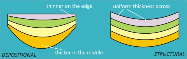
* Michigan is one of the areas shown on the map link above to be in a basin area, so I looked for a geologic cross section for Michigan and found that shape below: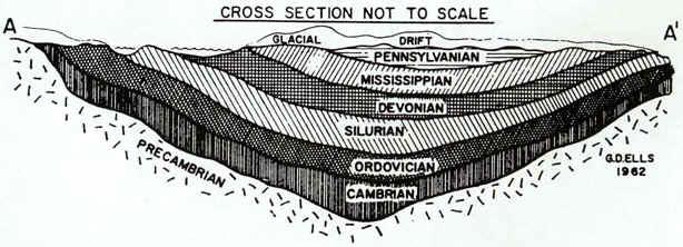
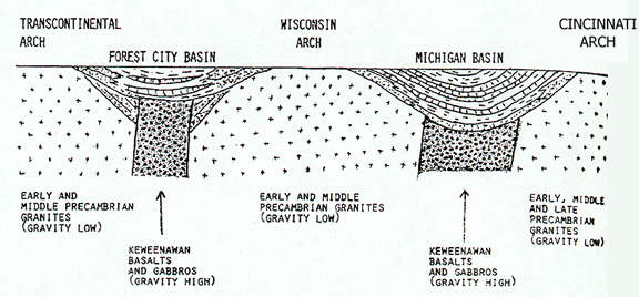
* Here's Michigan basin and another basin farther west:
* Now back to the original videos. They explain another geological oddity, some of the curved strata. Between 8 & 9 minutes into the second video at the main site that inspired this thread, http://www.sedimentology.fr, is a demo of how geologic "basins" filled in by catastrophic flooding, with the strata formed in concentric bowl shapes, something like in the image below. On the map at this wiki webpage, http://en.wikipedia.org/wiki/File:World ... vinces.jpg, basins are depicted in blue. So again the strata are not laid down bottom to top horizontally, but several strata form at once in bowl shapes with each inundation, until the basin is filled. I think we can ignore the words depositional and structural below.
* Michigan is one of the areas shown on the map link above to be in a basin area, so I looked for a geologic cross section for Michigan and found that shape below:
* Here's Michigan basin and another basin farther west:
Last edited by Lloyd on Sun Apr 04, 2010 7:35 pm, edited 1 time in total.
-
Lloyd
- Posts: 4433
- Joined: Fri Apr 04, 2008 2:54 pm
Re: Rock Strata Formation
* I thought the vertical shafts in the image above, below the two basins, was interesting, so I'm copying below what the website says about them [http://www.geo.msu.edu/geogmich/rift_zone.html]. First, here's a bird's eye view of the Michigan basin. I think the black section is called a rift, which must be the vertical shafts under the basins:
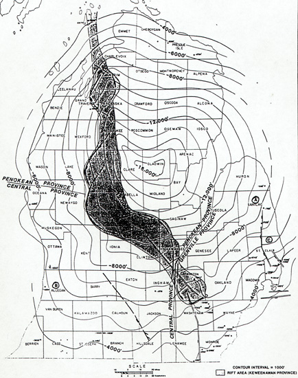
Rock formations in the rift zone
As the crust began to rift or split apart, volcanoes became active in the western Lake Superior region and violently ejected volcanic cinder, ash, and bombs. Then, somewhat subdued, these volcanoes poured out lava from long vents in quiet eruption. This lava is today called the Portage Lake Lava formation.
When the eruptions subsided, winds and weather broke up the lava flows into pebbles, gravel, sand, and fine muds, which became cemented together in a rock we call conglomerate, which would later form a rock called the Copper Harbor Conglomerate. In places the sands and fine muds became sandstones and shales, the Freda Sandstone and the Nonesuch Shale. Lava flows covered the conglomerates, more conglomerates were formed; they in turn were covered until several thousand feet of conglomerates and lava flows with sandstones and shales were built up. In the gas bubbles (amygdules) on top of the lava flows, in the cracks of the lavas and conglomerates, nature stored pure copper and silver and many interesting and beautiful copper minerals, the treasure store of Keweenaw, Houghton, and Ontonagon counties. The time in which these volcanic events were occurring is named the Keweenawan, the last part of the Precambrian era in Michigan.
Finally, on top of all these sediments that were accumulating in the rift zone, more sand was laid down, which eventually hardened into the beautiful, red, white and brown, Jacobsville Sandstone.
-
starbiter
- Posts: 1445
- Joined: Mon Mar 17, 2008 9:11 am
- Location: Antelope CA
- Contact:
Re: Rock Strata Formation
Hello Lloyd: You posted
"Rock formations in the rift zone
As the crust began to rift or split apart, volcanoes became active in the western Lake Superior region and violently ejected volcanic cinder, ash, and bombs. Then, somewhat subdued, these volcanoes poured out lava from long vents in quiet eruption. This lava is today called the Portage Lake Lava formation.
When the eruptions subsided, winds and weather broke up the lava flows into pebbles, gravel, sand, and fine muds, which became cemented together in a rock we call conglomerate, which would later form a rock called the Copper Harbor Conglomerate. In places the sands and fine muds became sandstones and shales, the Freda Sandstone and the Nonesuch Shale. Lava flows covered the conglomerates, more conglomerates were formed; they in turn were covered until several thousand feet of conglomerates and lava flows with sandstones and shales were built up. In the gas bubbles (amygdules) on top of the lava flows, in the cracks of the lavas and conglomerates, nature stored pure copper and silver and many interesting and beautiful copper minerals, the treasure store of Keweenaw, Houghton, and Ontonagon counties. The time in which these volcanic events were occurring is named the Keweenawan, the last part of the Precambrian era in Michigan.
Finally, on top of all these sediments that were accumulating in the rift zone, more sand was laid down, which eventually hardened into the beautiful, red, white and brown, Jacobsville Sandstone."
me again
This is obviously written by intelligent people with a time frame of hundreds of millions of years. And they must be correct, because they have names and dates for the layers. They own it.
The conglomerate they mention was described by the witnesses as falling from the sky. Sand and stone intermingled. In some cases red hot. Whenever these intelligent geologists see igneous rock they are forced to invoke disappearing volcanoes. In a catastrophic scenario, there is no time for the disappearing.
lloyd said
"To determine which sandstone etc formed from dunes, you'd have to get microscopic samples of the sand grains to see if they're well-rounded. Until that's done, it's just theory."
me again
I haven't found it necessary to carry a microscope. If you stop at the visitor centers in the parks, or BLM, they know what kind of rocks are present. Mudstone, siltstone, and shale have small, damaged grains like the picture you posted of beach sand. The one on the left. Sandstone has large undamaged grains like the picture on the right. It's apparently very consistent. And coincidentally, the sandstone structures look like dunes most of the time. I never claimed shale was the product of duning. Quite the opposite. I don't claim everything was a dune.
michael
I Ching #49 The Image
Fire in the lake: the image of REVOLUTION
Thus the superior man
Sets the calender in order
And makes the seasons clear
www.EU-geology.com
http://www.michaelsteinbacher.com
Fire in the lake: the image of REVOLUTION
Thus the superior man
Sets the calender in order
And makes the seasons clear
www.EU-geology.com
http://www.michaelsteinbacher.com
-
Lloyd
- Posts: 4433
- Joined: Fri Apr 04, 2008 2:54 pm
Re: Rock Strata Formation
* Somewhere there's probably information about what percent of sandstone consists of rounded grains, which might be from dunes. At this link http://www.earth.ox.ac.uk/~oesis/micro/index.html is a little info about several kinds of sandstone. 3 out of 4 seem to contain some rounded grains, but the matrix or cementing materials would likely not be from dunes. So I suppose the sands were mixed together with the cement somehow, such as by flood, and then hardened by heating, electrical breakdown, chemical action, or the like.
Sandstone: This sandstone is made of quite well rounded grains of quartz, cemented together by calcium carbonate. Cambrian, NW Scotland. Field of view 3.5 mm, polarising filters.
Sandstone (with mica): A fairly fine-grained sandstone made of rather angular grains of quartz and feldspar (feldspar looks more cloudy). Narrow flakes of mica, seen edge-on, and slightly crumpled, lie on bedding planes. Precambrian (Torridonian), Raasay, Inner Hebrides, Scotland. Field of view 3.5 mm.
Greensand: The green colour that this Cretaceous sandstone has in hand specimen comes from the rounded grains of the mineral glauconite, seen here among quartz grains in a matrix of clay and calcium carbonate. Field of view 3.5 mm.
Greywacke (impure sandstone): Greywackes are impure sandstones in which the grains are commonly made of feldspar and rock fragments as well as quartz. Notice that the grains have a wide range of sizes, and that some are rounded, some not. Field of view 5 mm, polarising filters.


-
webolife

- Posts: 2539
- Joined: Mon Mar 17, 2008 2:01 pm
- Location: Seattle
Re: Rock Strata Formation
Starbiter,
Your pictures show what Lloyd and I have been saying... that sandstone simply is just NOT all from duning, let alone granites and lavas... the first pic does appear to contain the rounded stones of beach forming and/or duning, but the others clearly cannot be from either of these processes, this material was broken, assembled and cemented with very little of the polishing process of wind or water transport involved. Perhaps there is electrical action here...who knows? But catastrophic processes are likely, or else every surface of every grain on Earth should show either crystaline form or polished roundness, or a combo of both, rather than the fragmented shardy appearance which is so common in these most common of rocks.
Your pictures show what Lloyd and I have been saying... that sandstone simply is just NOT all from duning, let alone granites and lavas... the first pic does appear to contain the rounded stones of beach forming and/or duning, but the others clearly cannot be from either of these processes, this material was broken, assembled and cemented with very little of the polishing process of wind or water transport involved. Perhaps there is electrical action here...who knows? But catastrophic processes are likely, or else every surface of every grain on Earth should show either crystaline form or polished roundness, or a combo of both, rather than the fragmented shardy appearance which is so common in these most common of rocks.
Truth extends beyond the border of self-limiting science. Free discourse among opposing viewpoints draws the open-minded away from the darkness of inevitable bias and nearer to the light of universal reality.
-
starbiter
- Posts: 1445
- Joined: Mon Mar 17, 2008 9:11 am
- Location: Antelope CA
- Contact:
Re: Rock Strata Formation
Hello Webo: I didn't make this up. Sandstone is either dune or beach/river beach. And you can differentiate the two/three.
http://jsedres.sepmonline.org/cgi/conte ... t/31/4/514
The mineralogy of clastic sediments for the most part seems to reflect the nature of the source rock, whereas textural parameters are chiefly related to the mode of transportation and the energy conditions of the transporting medium. Grain-size distribution analyses represent a plot of abundance or frequency against grain-size. Dune sands commonly can be distinguished from beach sands on the basis of such plots. The distinction between the sand types can be numerically stated by computing the third moment (skewness) of the distribution curve. On the phi scale the third moment (skewness) for dune sands is generally positive, whereas that of beach sands is generally negative. This seems to hold whether the dune samples are from barrier islands, coasts, lakes, rivers, or deserts. Beach sands of positive skewness occur on Padre Island, Texas, near the delta of the Rio Grande River, and on Horn Island, Mississippi. Sporadic positively-skewed beach sands have been found elsewhere, but for medium- to fine- and very fine-grained sands these appear to be relatively uncommon. Within the widely scattered samples a number of dune samples with slight negative skewness (-O.28 or less) have also been found. A plot of mean grain-size against third moment (skewness) results in an almost complete separation of the fields representing dune sands and beach sands. The sign of the skewness is not affected by the mineralogy of the sample. Sands of quartz, carbonate, gypsum, and olivine all follow the same general rule. The distribution curves of river sands like those of dune sands are generally positively skewed, but a number of exceptions to this rule have been noted. Within limitations, medium- to fine- and very fine-grained river sands can be distinguished from beach sands on the basis of plots of third moment (skewness) against standard deviation (sorting). The third moment (skewness) of coarse-grained sand is inconclusive as an indicator of depositional environment. Dune sands can commonly be distinguished from river sands by their sorting characteristics; dune sands tend to be better sorted than river sands. Since dune and river sands are skewed in the same direction, a further criterion is needed for distinguishing river from dune sands which have overlapping sorting characteristics. This has been found by separating the light mineral grains from those of the heavy minerals and determining the mean grain-size ratio of quartz and that of a specific heavy mineral in the same sand, such as garnet or magnetite. The ratio of the radius of quartz to that of a specific heavy mineral is usually larger for river sands than for dune sands.
The rest of the sedimentary rocks are deposited wet. And they can be differentiated.
Of course when the sand is converted to rock the picture changes, as Lloyd's photos above show.
michael
I Ching #49 The Image
Fire in the lake: the image of REVOLUTION
Thus the superior man
Sets the calender in order
And makes the seasons clear
www.EU-geology.com
http://www.michaelsteinbacher.com
Fire in the lake: the image of REVOLUTION
Thus the superior man
Sets the calender in order
And makes the seasons clear
www.EU-geology.com
http://www.michaelsteinbacher.com
-
Lloyd
- Posts: 4433
- Joined: Fri Apr 04, 2008 2:54 pm
Re: Rock Strata Formation
* That article completely ignores electrical pulverization & deposition of sand etc, as well as the Great Flood actions on rock and other sediment, both of which could easily be the main processes of sand and sandstone formation.
* This webpage mentions underwater dunes: http://geography.howstuffworks.com/term ... -dune2.htm. So it's not just windblown sand that can form dunes. The Great Flood could certainly have produced vast amounts of such dunes.
* This webpage mentions underwater dunes: http://geography.howstuffworks.com/term ... -dune2.htm. So it's not just windblown sand that can form dunes. The Great Flood could certainly have produced vast amounts of such dunes.
Interestingly, scientists have recently confirmed the existence of sand dunes underwater, using advanced sonar equipment. Called sand waves, they can reach up to 700 feet (213 meters) long and more than 30 feet (9 meters) high. Changing tidal patterns, sediment and erosion help these underwater dunes to form.
-
webolife
- Posts: 2539
- Joined: Mon Mar 17, 2008 2:01 pm
- Location: Seattle
Re: Rock Strata Formation
OK... I realize that I mispoke in using the term "very little" transport action... what I meant was that in terms of the time taken eg. under standard modeling, the amount of transport by wind or water is relatively short, hence the lack of rounded particles in MUCH of sandstone. If your duning scenatrios are likewise catastrophic/short time frame, then it is possible to support that hypothesis with the above shardy sandstone evidences. Electron micrographs of the cementaton process do not indicate much if any significant reshaping of the grains during cementation, so the polishing of the grains would have to do with duning activity as I see it. If this is the sole or primary method of sedimentary rock formation [duning then melting], why the predominantly shardy appearance?
Truth extends beyond the border of self-limiting science. Free discourse among opposing viewpoints draws the open-minded away from the darkness of inevitable bias and nearer to the light of universal reality.
-
starbiter
- Posts: 1445
- Joined: Mon Mar 17, 2008 9:11 am
- Location: Antelope CA
- Contact:
Re: Rock Strata Formation
Hello lloyd: I tried to find information from geologists on the nature of sand, and present it to the forum. You seem upset the geologists aren't presenting an EU perspective. If i have to find EU friendly geologists with written reports on the nature of things, it might prove quite limiting. I know of one in Australia, but i don't think he has published anything on the subject. I think the information presented is still helpful.
The fact that much of the sediment is extremely small implies an electrical origin. Some day the geologists might dig it.
Concerning the dunes on the sea floor, they might have formed underwater. But considering the changing sea levels, and land levels, there are other options.
Hello Webo: Yes, my duning model is rather catastrophic, not what we see today.
Concerning the shardy appearence of the grains in the rock, maybe the process of producing rock using plasma has something to do with it. I really don't know.
michael
I Ching #49 The Image
Fire in the lake: the image of REVOLUTION
Thus the superior man
Sets the calender in order
And makes the seasons clear
www.EU-geology.com
http://www.michaelsteinbacher.com
Fire in the lake: the image of REVOLUTION
Thus the superior man
Sets the calender in order
And makes the seasons clear
www.EU-geology.com
http://www.michaelsteinbacher.com
-
starbiter
- Posts: 1445
- Joined: Mon Mar 17, 2008 9:11 am
- Location: Antelope CA
- Contact:
Re: Rock Strata Formation
Hello Webo: I've been pondering your question about the rock close up images. The process that would unfold in an event described by mythology would not be neat. There would be a melange of constituents. You would have volcanoes erupting, and areas of different constituents being electrically excavated, during a hurricane. All of this would be electrically sorted depending on the ionic nature of the compounds produced. So i wouldn't expect the rocks to be clean. Consistency would be suspicious.
michael
michael
I Ching #49 The Image
Fire in the lake: the image of REVOLUTION
Thus the superior man
Sets the calender in order
And makes the seasons clear
www.EU-geology.com
http://www.michaelsteinbacher.com
Fire in the lake: the image of REVOLUTION
Thus the superior man
Sets the calender in order
And makes the seasons clear
www.EU-geology.com
http://www.michaelsteinbacher.com
-
Lloyd
- Posts: 4433
- Joined: Fri Apr 04, 2008 2:54 pm
Re: Rock Strata Formation
* I just heard of a Saturn theory that includes the idea that proto-Saturn used to have a disk, not the same as the present one, but I think somewhat similar, which was the source of most of the rock strata on Earth and on the other proto-Saturn satellites. I think the disk would blow out onto the satellites every time proto-Saturn flared up, every few thousand years, perhaps, and numerous rock strata would form each time. I think it was deposited electrically. Each flare-up would also cause a great flood from massive melting of glaciation, if I understand correctly. The glaciation only occurred for brief times between long periods of warm climate.
-
mharratsc
- Posts: 1405
- Joined: Mon Jan 26, 2009 7:37 am
Re: Rock Strata Formation
One thing that I think all you geologists should consider is the fact that electrical currents are flowing through these topographies you're talking about. Disregard rampant electrical deposition or excavation for a moment (which as Grey Cloud vehemently protested is entirely hypothetical), but consider the reality that anywhere water flows on this planet, then so does an electric current, and thus a non-zero electric and magnetic field.
This is Physics which humanity cannot seem to incorporate across disciplines for some reason (maybe aliens sabotaged our logic so we can't add 2 + 2 successfully anymore).
Meteorology. Geology. Physionomy. Oceanography. Where do you see anyone incorporating electrodynamics?
Nowhere.
Someone mentioned the ubiquitousness of Lichtenberg patterns... well duh! Why do you think? Electrodynamics are at every scale after all, aren't they? Whether you are discussing sedimentation, deposition, or erosion- there will still be a non-zero electrodynamic influence felt when a conductive medium is in motion within the Earth's magnetic field, however small it might be.
If you're going to be honest about it, then you have to incorporate ALL the physics together, just as Webolife stated earlier, don't you think?
I would like to make a comment before I forget:
Grey Cloud said:
It must be remembered that just as our common mechanical laws are valid on Earth at 1G, so too are the effects of electrodynamics of all ionized particles and electrons, but to any scale... because the scale of the particles themselves never change, just the quantity of them, right?
Also, it might be pertinent to point out that gravitational sorting of particulates by size is witnessed frequently in our doings here on Earth, but particulate sorting by material composition is the norm everywhere else in space- from Saturn out to planetary nebulae. Gravity may be stronger here than in those other two environs, but I doubt that electrodynamic influences are completely insignifigant though. Is it not possible that some of the existing explanations of sedimentary deposition and erosion do in fact have some electrodynamic influences that simply haven't been adequately treated (much as the obvious lack shown by Astronomy and Astrophysics?)
In my mind it boils back down to my original comment that the sciences just do not want to incorporate new knowlege of the characteristic behaviors of plasma and electrodynamics into their existing disciplines. Why should they, when existing laws are felt adequate to explain witnessed behaviors (as Grey Cloud has pointed out?)
Simply this- because electrodynamics affect everything, and to not incorporate them is to ignore fundamental physics of our Universe.
Respects--
This is Physics which humanity cannot seem to incorporate across disciplines for some reason (maybe aliens sabotaged our logic so we can't add 2 + 2 successfully anymore).
Meteorology. Geology. Physionomy. Oceanography. Where do you see anyone incorporating electrodynamics?
Nowhere.
Someone mentioned the ubiquitousness of Lichtenberg patterns... well duh! Why do you think? Electrodynamics are at every scale after all, aren't they? Whether you are discussing sedimentation, deposition, or erosion- there will still be a non-zero electrodynamic influence felt when a conductive medium is in motion within the Earth's magnetic field, however small it might be.
If you're going to be honest about it, then you have to incorporate ALL the physics together, just as Webolife stated earlier, don't you think?
I would like to make a comment before I forget:
Grey Cloud said:
That is rather unkind treatment of Alfven's memory, just to win a point in an argument. Besides- to what scale did Dr. Berthault run his simulation? Let's not be hypocritical.He had a cosmic-sized lab, did he? Or is it more theory?“Hannes Alfven showed that lab demonstrated electrical effects are scalable up to cosmic proportions”.
It must be remembered that just as our common mechanical laws are valid on Earth at 1G, so too are the effects of electrodynamics of all ionized particles and electrons, but to any scale... because the scale of the particles themselves never change, just the quantity of them, right?
Also, it might be pertinent to point out that gravitational sorting of particulates by size is witnessed frequently in our doings here on Earth, but particulate sorting by material composition is the norm everywhere else in space- from Saturn out to planetary nebulae. Gravity may be stronger here than in those other two environs, but I doubt that electrodynamic influences are completely insignifigant though. Is it not possible that some of the existing explanations of sedimentary deposition and erosion do in fact have some electrodynamic influences that simply haven't been adequately treated (much as the obvious lack shown by Astronomy and Astrophysics?)
In my mind it boils back down to my original comment that the sciences just do not want to incorporate new knowlege of the characteristic behaviors of plasma and electrodynamics into their existing disciplines. Why should they, when existing laws are felt adequate to explain witnessed behaviors (as Grey Cloud has pointed out?)
Simply this- because electrodynamics affect everything, and to not incorporate them is to ignore fundamental physics of our Universe.
Respects--
Mike H.
"I have no fear to shout out my ignorance and let the Wise correct me, for every instance of such narrows the gulf between them and me." -- Michael A. Harrington
"I have no fear to shout out my ignorance and let the Wise correct me, for every instance of such narrows the gulf between them and me." -- Michael A. Harrington
Who is online
Users browsing this forum: No registered users and 71 guests