I believe I have the Texas flood and canyon 'formation' event figured out Micheal, and it explains a puzzle I had about some of my local geology. The picture popped into my head while I was watching a Velikovsky documentary, my subconscious must have been chewing it over.
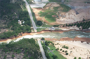
Anyway, the answer is that NO water was involved with the formation of the canyon supposedly cut by the dam overflow. Nor was any water involved with the cutting of the Guadalupe River. They were both electrically excavated. The freshly cut canyon from the flood was actually there before the main channel that now leads up to the dam. All the sedimentary/fluvial layers that are visible along the banks of the flood excavation are what was torn out of the canyon, lofted in billowing clouds, and then settled back down, sorted as it fell , and covering the whole area, with much falling back into the excavated canyon.
The discharge channel then switched to what is now the Guadalupe, which cut deeper into the rock than the smaller one. This may have been only seconds after the first one was cut. Afterwards, when water entered the picture, it flowed down the deeper channel, and the water never flowed down the smaller one. The loose material that had filled the Guadalupe was washed away, leaving the bigger chunks in the river bed, and exposing the layered deposits lining the river.
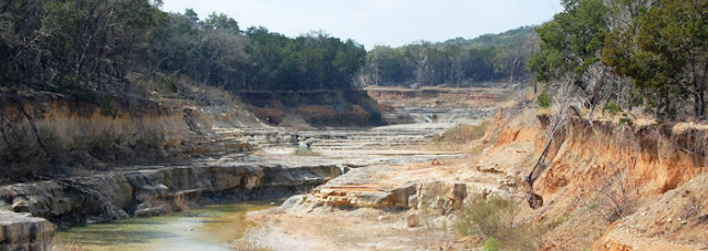
The smaller channel may have had just some local drainage, but never a substantial flow. When the dam was built, it meant that at flood stage, the water backed up enough to allow it to enter the smaller channel which was still mostly filled with the layered deposits from the electrical excavation, and so all the dirt and smaller rock was washed away, as had happened along the Guadalupe. So now we see the layered deposits along the bank, and there are some rocks and boulder piles where the larger chunks have collected in eddies formed in the flood event.
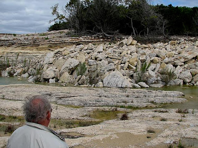
But, there is by no means anywhere near the volume of rocks and boulders present in the 'new' channel, or the Guadalupe, to account for the volume of material removed, and that is because it was all turned to the dust and fine material that fills the Guadalupe river and lies along the banks and probably outside of the river banks for some distance.
Images from:
http://texasgeology.blogspot.ca/2012/09 ... ophic.html
Google maps shows where the new canyon was formed, but you can see, with the terrain view, that there was already a valley there, which was filled with the debris from the original excavation.
https://maps.google.com/maps?q=maps+can ... e&t=p&z=15
I have a similar occurence around here, but the lake has not yet risen to a point where the secondary channel has been flooded, but I am confident that if I were to excavate in the centre of what is now a shallow, broad gulley, I would find just the same layering of debris, and a ragged canyon at the bedrock level. I hope you follow my reasoning here Michael, as I am very confident that this is what happened, both in Texas, and around here. Now I have seen this process, I'll bet by using Google maps I can identify more 'dry' creeks and rivers.
I did find the Velikovsky videos interesting, though I still think it possible that some of what was seen by observers at the time might be explained by other processes. I just KNEW that once I started into Velikovsky it would open up a whole new, and very large area of study, and I really can't fit any more on my plate right now! Maybe I'll just let my subconscious chew on it and wait for some answers to pop out when they are good and ready?

In order to change an existing paradigm you do not struggle to try and change the problematic model. You create a new model and make the old one obsolete. -Buckminster Fuller

